|
||||||||||||||||||||||||
|---|---|---|---|---|---|---|---|---|---|---|---|---|---|---|---|---|---|---|---|---|---|---|---|---|
Chopicalqui - Millisraju ExpeditionInto the Santa Cruz
July 12, 2005 – A Long Walk to the Alpa Mayo Base Camp
The Santa Cruz valley is a pretty good distance north of Huaraz and the drive to the stepping off point of Cashapampa takes about three hours (map). The alarm went off at 3 a.m. and we dragged ourselves out of bed to meet Elias and Joaquin at the Meza lodging front door. We were on track for a 4 a.m. departure and a 7 a.m. arrival in Cashapampa and a prompt departure up into the Quebrada Santa Cruz.
We discussed our approach the night before and noted that the trip to the Alpa Mayo base camp is generally a two-day trip. The first day covers the distance from Cashapampa to the Llama Corral and then the next day groups go from the Corral to the Base Camp proper. This scheme allows two days to acclimatize over a distance of 14 miles and an elevation gain of about 4500 feet, from 9500 feet to 14,000 feet. Our schedule did not allow for two days and Joaquin, summitteer of Huascaran 118 times, assured us that the hike in was not a bad day’s walk. Elias was good for the one-day plan as well. Given our desire to go for Quitaraju, one day became the plan we simply did not have enough time to make the approach and retain a slack day for any issues that might arrive Quitaraju.
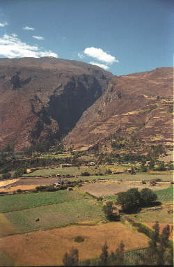
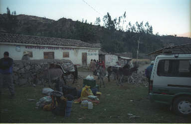
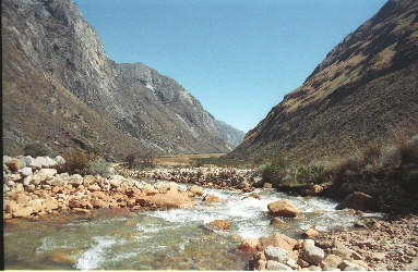
The trip up to Cashapampa covered the now familiar route to Yungay in the early morning darkness, after which we left the main road just past Caraz and took a dirt road up into the mountains. The route cuts back and forth time and time again, skirting the edge of the valley high atop a steep and unforgiving slope. The trip to Cashapampa takes a good hour and you know you are close when the road turns directly toward the Blanca and you notice a village nestled right below the cleft that is the mouth of the Santa Cruz. The valley entrance is literally a gap gouged in a nearly continuous mountain wall. Our Toyota van pulled through the village and into a stone corral where we dismounted to get our gear in order for the arriero to re-pack and then load onto the burros. Perhaps 20 minutes passed before a string of six burros arrived and the arriero and his wife began packing the animals for the long day’s walk into the valley.
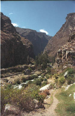
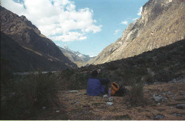
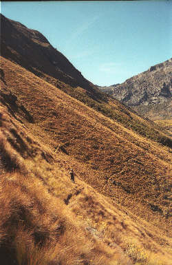
As Elias and Saltille (arriero) completed assembling the pack train, Joaquin, G and I started the march that promised to last most of the day. The trail starts off by briefly continuing up the road and then paralleling an irrigation canal the traverses the face of the mountain front before turning the enter the canyon proper. The trail passes a number of artificial ponds, through a stone gate and then begins its climb in earnest. Chris had forewarned us that the first mile and a half would be steep and hot and he was right on with his description. The trail climbs steeply and as the sun slowly rose higher and higher, the walk began to take on some serious warmth. We trudged on, knowing that the first 1.5 miles would come to an end and sure enough the grade broke after that distance.
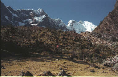
Once the course up the valley mellowed, we took a food and drink break and began to take in the absolutely awesome scenery that makes the route through the Santa Cruz a very popular trek with non climbers. The towering walls of the canyon and the trees along the creek are covered with patches of flowering bromeliads and small waterfalls abound. The trail parallels the creek and only the need to cover the full 14 miles in one day kept us from just stopping more often just to take in the scenery. The route continues to gently climb and after about five miles one reaches the Llama Camp. This wide and grassy flat area is the first camp for the groups trekking the Santa Cruz and since it was mid morning, the camp was empty of trekkers enroute to their next camp. Had we another day in our schedule, it would have been our first night’s stay as well but we still had about 8 miles to go before we stopped for the day.
We continued on, keeping in mind that our next visible sign of progress would be the pair of lakes, first of which would mark the halfway point of the approach. The trail climbs in small fits and starts, separated by flats before you suddenly reach the first lake. We passed the first lake on the right side and moved on up the slope to the dam holding back the upper and larger lake. The dam made for another good break point before we again skirted along the right edge of the lake and out onto the flat pasture above. The pasture easily extends for a mile and the trail takes a path more of less up the center. The creek however meanders and is crossed on a number of bridges constructed of branches and sod interwoven to form a crossing. Following the pastures, we began to climb again for a relatively short distance before reaching Quishuar, the juncture between the main trail and the cut off leading up, of course, to the Alpa Mayo Base Camp.
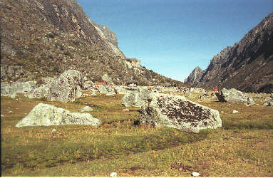
The next challenge was a short but never the less endless set of about eight switchbacks that lead to the hanging valley above. We set our sights on conquering one switchback at a time, landing at the foot of the hanging valley soon enough. From there the route was easy, we traversed the hanging valley floor for perhaps another one and one half miles to the official Alpa May base camp.
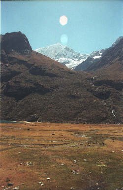
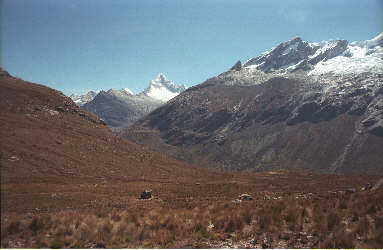
Elias and the burro train first passed us just above the steep portion of the trail, early in the day, and then we swapped the lead off and on for the rest of the day. Elias and Saltille did; however, make it to the base camp about 20 minutes ahead of us, following a final pass at the top of the switchbacks that once again put them in the lead. The cook tent was up upon our arrival and post hike snack laid out in preparation for the dinner to follow. We got our tents set up and then had time to look about at this truly incredible campsite. High above loomed the summit of Alpa Mayo, the peak referred to by many as the most beautiful in the world. Further along lay the flank of Quitaraju, the climb we planned to start in the morning. Behind us lay the discontinuous heights of the Nevados Pucajirca and Pucarashta. Across the valley lay Artesanraju, our original goal.
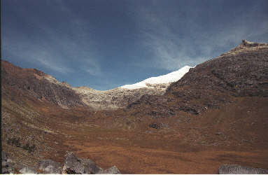
We took a hard look at the route up to the Alpa Mayo/Quitaraju col and noted the route being taken by other climbers coming down after their ascents. A concern that came quickly to the fore for us were the ice walls and seracs that overhung the route taken by the other climbers. We looked and looked but just could not come to a comfortable feeling about that overhanging ice. That evening we spread the topo map on one of the packing boxes and started quizzing Joaquin as to alternate and less popular summits in the surrounding valleys (map). We first looked at Curuicashashajana and Rinrijirca and discussed possible approaches to these summits. Joaquin advised that the map obvious approach from the Lago Arhueycocha was a mass of hanging seracs and that Curuicashashajana would be best approached from the south. We also looked at the connecting ridge between Curuicashashajana and Rinrijirca and came to the conclusion that the ridge would be one seriously challenging fluted cornice. We started looking further afield and noted 5500m Millisraju lying opposite Artesan. The approach from the west looked doable but also had the appearance of a jumble of class 4 bands but the eastern approach appeared, on the map, to have a trail of sorts up the Sentilo sub valley. The glacier noted on the map also appeared to offer a ridge route to the summit. We put all of our eggs in one basket, decided not to attempt Quitaraju but instead we would make a long recon trip into the Sentilo valley to look at 5500m Millisraju. Joaquin had been to the summit twice before but had not been on the peak in 15 years, leaving the condition of the glacier as an unknown to everyone. We hit the tents, admittedly a bit disappointed having chosen not to take a shot at Quitaraju but alternatively enthusiastic about the possibility of leaving the guide book path for a lesser climbed peak.
July 13, 2005 – Millisraju Recon Hike
The next day promised to be a rest day for Elias and Saltille but a long recon walk for G, Joaquin and myself (map). We had breakfast, were issued a box lunch and then headed down the hanging valley early enough to do most of the trip in the early morning shadows. Rather than drop back down through the series of switchbacks to Quishuar, we took a traversing trail (obvious) that conserved altitude and deposited us at an equivalent elevation in the main Santa Cruz valley. We walked up valley a short distance and arrived at the Taullipampa camp where the trekking parties generally make their second night’s stop.
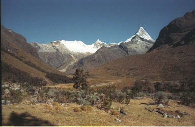
We continued up valley, now walking toward the incredible west face of Tallarauju, a seemingly impossible challenge guarded by vertical faces and hanging seracs. Certainly not in our league. Instead we moved up the valley until we reached a good point to cut off below the first switchbacks on the trail leading to Punta Union. Though the map shows a trail, there are occasional segments at best and for the most of our recon, we just bushwhacked up the valley, past a grazing cow here and there. We stuck to the eastern flank of the valley, perhaps one hundred meters higher than the marshy valley floor. We walked about half way up the valley until we could see the glacier and get some idea of whether the route we selected was accessible and at least appeared viable with regard to the condition of the glacier.
We found the route up the valley to be readily accessible for the pack train and that there appeared to be a flat suitable for camping just below the steep headwall leading to the glacier. Joaquin indicated that when he had climbed the peak before, they had camped at the flat spot but that the glacier looked different from his past ascents and appeared to have both retreated and broken up a bit. We spent a lot of time glassing the potential route up the glacier and felt there and there was a circuitous but viable path through the crevasses to the summit. No telling the condition of the snow bridges or just how large the obvious summit moat was but we had seen enough on the positive side to toss the guidebook aside and take a shot at the summit of Millisraju. Satisfied with our progress, we sat down for lunch before heading back to our camp, about four miles distant, at the base of Alpa Mayo. We left the Sentilo and regained the well-trodden trekking route, traversed along the side slopes above the switchbacks above Quishuar and on back up the hanging valley to our camp. Elias had a late afternoon snack ready and a dinner soon followed. We huddled in the cook tent and discussed our goal to take a shot a Millisraju and the plan for the next day . . . a complete move of the camp to the flat spot below Millisraju’s eastern flank. |
