Half Peak
July 9, 2010 - via Cataract Lake
I took a Friday off and drove to Lake City, making good time and hoping to arrive far enough ahead of the weekend crowd to secure a spot at the Mill Creek Campground, about 10 miles outside of town. I had not been to the San Juan range for a year as my last visit to the area was with Ed
in 2009 for spring snow climbs of the Wetterhorn and Uncompahgre. Work of late had been a bear and a couple of Centennials in the San Juans was just what the psyche needed. I figured Half Peak and Points 13,832 and 13,811 would do the trick.
 I'd read a recent trip report about the Cataract Lake route on Half Peak and the photos intrigued me enough that I thought taking the same route was in order. I arrived at the campground at around 8 p.m. on Thursday ngith and picked up a plum spot that would offer shade during the day and the background noise of a creek but 15 feet away. I rarely find it hard to get to sleep when camping, especially post climb, but a dose of creek sounds certainly would not hurt. I pitched the tent, ate a light dinner and called it a night at about 9:30. I set the alarm for 4 a.m. and hoped that my deaf ears would pick up the sound. This was a solo trip so there was no keen eared partner to sound the wake up call. I'd read a recent trip report about the Cataract Lake route on Half Peak and the photos intrigued me enough that I thought taking the same route was in order. I arrived at the campground at around 8 p.m. on Thursday ngith and picked up a plum spot that would offer shade during the day and the background noise of a creek but 15 feet away. I rarely find it hard to get to sleep when camping, especially post climb, but a dose of creek sounds certainly would not hurt. I pitched the tent, ate a light dinner and called it a night at about 9:30. I set the alarm for 4 a.m. and hoped that my deaf ears would pick up the sound. This was a solo trip so there was no keen eared partner to sound the wake up call.
 The alarm went off as scheduled and I slept right through it. This was not a case of being tired but of having darn little high end hearing left on one side after 16 years in the underground and open pit mining business. Word to the wise . . . the immortality of youth pays negative dividends to those who fail to heed the warnings given seriously and taken casually. I opened my eyes and there was too much light so I reached for the alarm and, to my alarm, it was 5:10, a full ten minutes past my planned trail head departure time. &%$# . . . I was out of the tent in about one minute flat cursing my failure to wake on time and wondering if the weather report that called for a chance of afternoon thunderstorms would come true and potentially cut the climb short. I was not happy. The alarm went off as scheduled and I slept right through it. This was not a case of being tired but of having darn little high end hearing left on one side after 16 years in the underground and open pit mining business. Word to the wise . . . the immortality of youth pays negative dividends to those who fail to heed the warnings given seriously and taken casually. I opened my eyes and there was too much light so I reached for the alarm and, to my alarm, it was 5:10, a full ten minutes past my planned trail head departure time. &%$# . . . I was out of the tent in about one minute flat cursing my failure to wake on time and wondering if the weather report that called for a chance of afternoon thunderstorms would come true and potentially cut the climb short. I was not happy.
I drove on up the road, eating a banana for breakfast and thinking that at least I had been wise enough to pack everything for the climb the night before so that all I had to do was reach for the pack and hiking poles to be on my way.
I found the Cataract trail head without problem and left the truck roadside, stashing the keys in the usual spot and hefting the pack to start the hike. As I was solo, I took along the iPod, 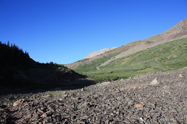 which I am still not fully at ease with as a means of killing some of the boredom of solo hiking versus something that that has no place in the mountains. Therefore and as a borderline Luddite, I've kind of set some rules for the iPod that limit it to class 1 routes and I pop the earplugs out whenever passing someone so that I can converse and there is not doubt that I'm not "multi-tasking." This would probably be a non issue to a 25 year old but as one who remembers Apollo first hand, the ear buds come out when conversing. which I am still not fully at ease with as a means of killing some of the boredom of solo hiking versus something that that has no place in the mountains. Therefore and as a borderline Luddite, I've kind of set some rules for the iPod that limit it to class 1 routes and I pop the earplugs out whenever passing someone so that I can converse and there is not doubt that I'm not "multi-tasking." This would probably be a non issue to a 25 year old but as one who remembers Apollo first hand, the ear buds come out when conversing.
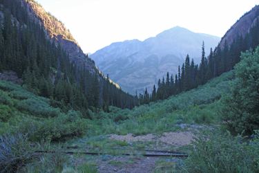
The trail started off flat until the first creek crossing which was easily accomplished via a substantial log and a few extra smaller ones through along side for good measure. Once across the creek I started up the now ascending 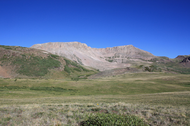 trail that soon took a turn to the left and began a series of switchbacks up through the woods. The trail left the side of the creek that tumbles and falls through the canyon and steadily climbed through the switchbacks, later rejoining the creek, basically a steep ascent but for the places where it was even steeper. The grade mellowed as I reached the upper portion of the drainage and came to an old tailings pile with two pieces of ten pound rail projecting out of the brush filled cut that undoubtedly led to a collapsed mine adit. I say collapsed as I could not pick up the slightest whiff of "mine air", a smell that brings back memories of a prior career. trail that soon took a turn to the left and began a series of switchbacks up through the woods. The trail left the side of the creek that tumbles and falls through the canyon and steadily climbed through the switchbacks, later rejoining the creek, basically a steep ascent but for the places where it was even steeper. The grade mellowed as I reached the upper portion of the drainage and came to an old tailings pile with two pieces of ten pound rail projecting out of the brush filled cut that undoubtedly led to a collapsed mine adit. I say collapsed as I could not pick up the slightest whiff of "mine air", a smell that brings back memories of a prior career.
 After eating a second banana that I managed to get this far without mashing, I was off again
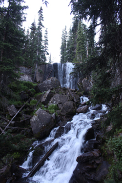
and soon came to a point where the trail crossed the creek and before climbing to a second creek crossing. Between the points is undoubtedly one of the most pretty waterfalls I've yet to see anywhere in my travels. I stopped to take a few photos before following the trail around to the top of the falls and on across the creek to continue climbing. The third creek crossing came 5 minutes later, after which the trail climbed out of the trees and into the open for the remainder of the ascent. The route traversed a large talus covered bottom and climbed at a more relaxed pace before again coming to the creek for its final crossing, this time protected by an easily navigated maze of willows. After eating a second banana that I managed to get this far without mashing, I was off again
and soon came to a point where the trail crossed the creek and before climbing to a second creek crossing. Between the points is undoubtedly one of the most pretty waterfalls I've yet to see anywhere in my travels. I stopped to take a few photos before following the trail around to the top of the falls and on across the creek to continue climbing. The third creek crossing came 5 minutes later, after which the trail climbed out of the trees and into the open for the remainder of the ascent. The route traversed a large talus covered bottom and climbed at a more relaxed pace before again coming to the creek for its final crossing, this time protected by an easily navigated maze of willows.
 Once through the willows the trail ascended and made a hard left turn away from the stream and the base of the valley. My map led me to believe that the course would stick fairly close to the creek until Cataract Lake was reached but this path was too strong to ignore and the thought of striking out through willows was simply not a thinking person's option. I left the valley bottom and took the obvious course up and to the left. The path twisted and turned to gain elevation but did indeed head up valley, albeit on the back side of a ridge. I found the course confusing and, more than once, I took out the map to wonder if there was a cut off that I had missed or if I was somehow on a trail to some point other than the lake I wanted to get to. Once through the willows the trail ascended and made a hard left turn away from the stream and the base of the valley. My map led me to believe that the course would stick fairly close to the creek until Cataract Lake was reached but this path was too strong to ignore and the thought of striking out through willows was simply not a thinking person's option. I left the valley bottom and took the obvious course up and to the left. The path twisted and turned to gain elevation but did indeed head up valley, albeit on the back side of a ridge. I found the course confusing and, more than once, I took out the map to wonder if there was a cut off that I had missed or if I was somehow on a trail to some point other than the lake I wanted to get to.
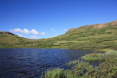
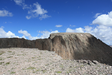
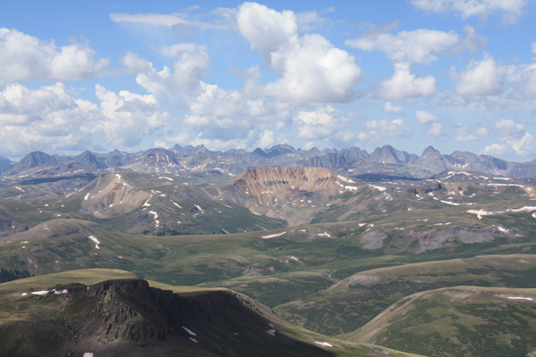
 I kept climbing and soon enough topped out on high ground that rejoined the valley that held the creek off to my ascending right. The terrain took on a rolling aspect, well above tree line and one could see Half Peak to the right but it sure didn't look like what I expected from the various guidebook photos. The view is of the flank of the peak, which presents itself as a cliff band not readily discernable as the "peak" but for the story told by the map in my hand. The trail continued to gently climb after passing a small and very shallow pond to my right. I soon came to Cataract Lake, which was a substantial lake and my arrival was timed perfectly as my Camelback was just about empty.
I found a game path to the water's edge and pumped a quart into the bladder, enough that I would get to the summit and back without carrying a lot of excess water weight. I kept climbing and soon enough topped out on high ground that rejoined the valley that held the creek off to my ascending right. The terrain took on a rolling aspect, well above tree line and one could see Half Peak to the right but it sure didn't look like what I expected from the various guidebook photos. The view is of the flank of the peak, which presents itself as a cliff band not readily discernable as the "peak" but for the story told by the map in my hand. The trail continued to gently climb after passing a small and very shallow pond to my right. I soon came to Cataract Lake, which was a substantial lake and my arrival was timed perfectly as my Camelback was just about empty.
I found a game path to the water's edge and pumped a quart into the bladder, enough that I would get to the summit and back without carrying a lot of excess water weight.
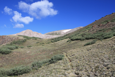
 I now looked to my map, seeking the next small lake that I would should traverse to the right of before taking a meandering path on up the hill toward the gently sloping back of the peak. I climbed to the saddle at the head of the valley and there, just shy of the opposite side drop, was the small lake. Instead of cutting right, I held left, on a solid trail and came around to the far side of the pond. The guidebook route then cuts off,
which did not seem to jibe with the solid trail underfoot. I went another 100 yards before giving in to the guidebook route and cutting off the well beaten path and upon onto the grassy slopes. I managed to get atop the cliff that the trail cuts below and then had to work my way across a talus slope to meet up with the trail that cuts up into the side drainage that leads to the back of Half Peak. I now looked to my map, seeking the next small lake that I would should traverse to the right of before taking a meandering path on up the hill toward the gently sloping back of the peak. I climbed to the saddle at the head of the valley and there, just shy of the opposite side drop, was the small lake. Instead of cutting right, I held left, on a solid trail and came around to the far side of the pond. The guidebook route then cuts off,
which did not seem to jibe with the solid trail underfoot. I went another 100 yards before giving in to the guidebook route and cutting off the well beaten path and upon onto the grassy slopes. I managed to get atop the cliff that the trail cuts below and then had to work my way across a talus slope to meet up with the trail that cuts up into the side drainage that leads to the back of Half Peak.
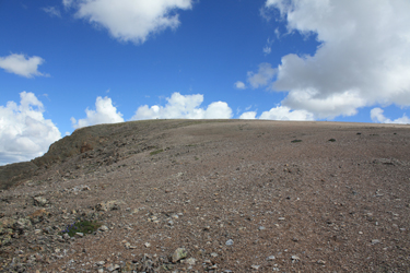
 I had it stuck in my mind that the obvious trail would surely descend down the main valley and the loss of elevation that would result from taking it for any real distance would be a wasted effort. In hind sight, such is not the case, as that well beaten trail would have taken me right to the back of the peak, making my guidebook effort, a fool's errand. What I realized is that the back of Half Peak is just a slope and until I got a ways up on on the slope, probably to an elevation of 13,500, I never really saw the topography that I was expecting to see.
I came back to the strong trail via a talus traverse on a strong climber's trace, clearly indicating that I was not the only person to not accept the obvious path as the obvious path. I entered the side drainage shown on the map I had it stuck in my mind that the obvious trail would surely descend down the main valley and the loss of elevation that would result from taking it for any real distance would be a wasted effort. In hind sight, such is not the case, as that well beaten trail would have taken me right to the back of the peak, making my guidebook effort, a fool's errand. What I realized is that the back of Half Peak is just a slope and until I got a ways up on on the slope, probably to an elevation of 13,500, I never really saw the topography that I was expecting to see.
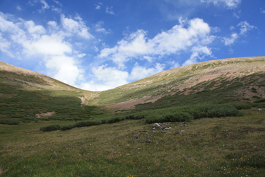
I came back to the strong trail via a talus traverse on a strong climber's trace, clearly indicating that I was not the only person to not accept the obvious path as the obvious path. I entered the side drainage shown on the map 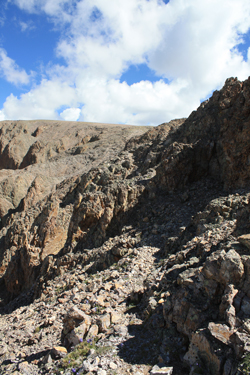 and hiked the strong trail until it sought to cut hard left and ascended to a saddle. I was faced with the saddle to the left, the saddle right in front of me but sans trail or a draw to my right that was without trail but in my humble opinion, the best way to go. and hiked the strong trail until it sought to cut hard left and ascended to a saddle. I was faced with the saddle to the left, the saddle right in front of me but sans trail or a draw to my right that was without trail but in my humble opinion, the best way to go.
I went right and for some reason really struggled with the elevation as I climbed up through the center cleft and then circled around to the left in order to gain the skyline. I found the gentle topography to be really confusing but figured if I could cut the skyline, I'd spot enough of the peak to find the growingly elusive route. Skyline turned out to be the key and actually about 1/4 mile before the skyline, the slope eased enough to allow me to recognize the advertised topography. I also spotted another climber with dog ahead of me who had crossed the class 2 connecting ridge and was now nearing the summit. I continued to plod on to the edge of the cliff that narrows to form the hourglass like isthmus that leads to the summit slope proper.
 From a distance, the connecting hourglass like waist seems like some real solid climbing, if not technical. But . . . upon closer inspection, there truly was a class 2 route right across. I recall shifting both hiking poles to one hand but once or twice for a move or two but the vast majority of the course is just exposed class two trail. Once across, I started my hike to the summit proper, which is clearly just a highpoint on the sloping summit plateau that cliffs out into the valley below. From a distance, the connecting hourglass like waist seems like some real solid climbing, if not technical. But . . . upon closer inspection, there truly was a class 2 route right across. I recall shifting both hiking poles to one hand but once or twice for a move or two but the vast majority of the course is just exposed class two trail. Once across, I started my hike to the summit proper, which is clearly just a highpoint on the sloping summit plateau that cliffs out into the valley below.
I am always prepared for the unexpected in climber antics on the 14'ers, you have to be, there is simply a plethora of Cottoneers out there who
just don't know better. The advantage of the Centennials and lesser peaks is that one generally comes across a better grade of 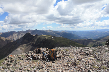 climber and I assumed that of the fellow ahead of me with his dog. What a surprise . . . the dog comes bounding my way, with owner in hot pursuit. Fido is barking up a storm and getting closer and closer until he arrives, barking and can you believe it . . . making a run at my leg. I gently pushed him away with a hiking pole after which he decided to circle 90 degrees and make another run at an ankle. Fido never heard the old saying about "taking a knife to a gunfight." Well that's what the hound showed up with and I greeted his second approach with a healthy backswing and subsequent solid crack of a hiking pole across the side of his head. climber and I assumed that of the fellow ahead of me with his dog. What a surprise . . . the dog comes bounding my way, with owner in hot pursuit. Fido is barking up a storm and getting closer and closer until he arrives, barking and can you believe it . . . making a run at my leg. I gently pushed him away with a hiking pole after which he decided to circle 90 degrees and make another run at an ankle. Fido never heard the old saying about "taking a knife to a gunfight." Well that's what the hound showed up with and I greeted his second approach with a healthy backswing and subsequent solid crack of a hiking pole across the side of his head.
His owner arrived at about the same time as Fido realized that keeping a safe distance was probably the better part of valor. Owner could not manage to get Fido to come close enough to get a 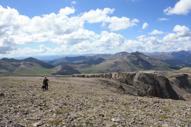 leash on him so dog and owner followed me back to the summit before the hound would stop and sit. Owner apologized for the incident and we amicably chatted climbing for a bit but, in the end, the owners sheer irresponsibility still amazes me. I would not want to be in his shoes the next time his dog pulls a stunt like that with a 5 year old out for a hike with the family. leash on him so dog and owner followed me back to the summit before the hound would stop and sit. Owner apologized for the incident and we amicably chatted climbing for a bit but, in the end, the owners sheer irresponsibility still amazes me. I would not want to be in his shoes the next time his dog pulls a stunt like that with a 5 year old out for a hike with the family.
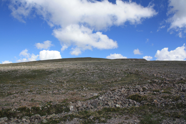
I found the summit of the peak to be unusual as it is a large sloping plateau that is "surfaced" with small gravel . . . it was like walking up an old fashioned cinder parking lot. I dropped my pack at the summit rock pile and took some photos before shooting Gu and then soon enough hefting the pack for the trip back down. I again crossed the connecting ridge and then veered to the right instead 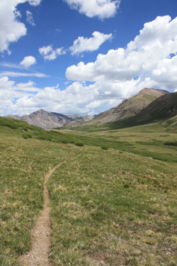 of tracing the route and gully that I had climbed up. Having now had the chance to see the layout from above, I elected to drop to the saddle that was the earlier center option, down which I descended to the strong trail below. Once I regained the trail, I made fast time down and out of the side drainage and back to the small lake above Cataract Lake. of tracing the route and gully that I had climbed up. Having now had the chance to see the layout from above, I elected to drop to the saddle that was the earlier center option, down which I descended to the strong trail below. Once I regained the trail, I made fast time down and out of the side drainage and back to the small lake above Cataract Lake.
From there it was a retrace of the ascent past the main lake, around the initially confusing fin and then on back down the trail through the willows and talus to the wood line and falls below. I stopped at the crossing above the falls to pump a half quart for the rest of the descent and then steadily hiked back
down the steeper and by then switch backing trail through the pines to the log crossing and the truck.
|
