-
Mt. Bierstadt Group Summit - Front Range, Colorado
-
A rest before the summit push on Dallas Peak - San Juan Range, Colorado
-
Broken Ankle + 6 Miles = Tired
-
The classic San Juan approach - San Juan Range, Colorado
-
Overlooking Noname Basin from Twin Thumbs Pass - San Juan Range, Colorado
-
Upper Noname Basin - San Juan Range, Colorado
-
Nearing Noname Cabin - San Juan Range, Colorado
-
Twin Thumbs Twins - San Juan Range, Colorado
-
Nearing the summit of Pt. 13,736 - Sawatch Range, Colorado
-
Blustery day on Iowa Peak - Sawatch Range, Colorado
-
Morning snow at 15k, Cerro Ramada - Cordillera Ramada
-
Artesonraju from the summit of Nevado Pisco - Cordillera Blanca, Peru
-
February crowds on Gray's Peak - Front Range, Colorado
-
Kicking steps on Cerro Lliani - Cordillera Vilcanota, Peru
-
Final traverse to the summit of Wheeler Mountain - Ten Mile Range, Colorado
-
The long walk to Pachanta - Cordillera Vilcanota, Peru
- banner31
Afternoon at 17k on Cerro Ramada - Cordillera Ramada, Argentina
- banner22
The final ridge on Iowa Peak - Sawatch Range, Colorado
-
Summer summit on Longs Peak - Front Range, Colorado
-
A rest day at the Pachanta Hot Springs - Cordillera Vilcanota, Peru
-
Mind over matter on Mt. Parnassas - Front Range, Colorado
-
Rest stop on Cerro Lliani - Cordillera Vilcanota, Peru
- banner30
Post nap surprise on Cerro Ramada - Cordiller Ramada, Argentina
-
Summit on Cerro Lliani - Cordillera Vilcanota, Peru
- banner23
Ridge walking on Grizzly Peak - Sawatch Range, Colorado
-
Enroute the summit via the West Ridge on Pacific Peak - Ten Mile Range, Colorado
-
Mule train bound for Chilca - Cordillera Vilcanota, Peru
-
Taking in the view from Fletcher Peak - Ten Mile Range, Colorado
-
Hiking on Silverheels - Mosquito Range, Colorado
-
Traversing! Gladstone Peak - San Juan Range, Colorado
- banner24
The best of times at Willow Lake - Sangre de Christo Range, Colorado
- banner29
High Altitude Cerebral Edema? - Cordillera Ramada, Argentina
-
Bound for Chilca - Vilcanota Range, Peru
-
Going alpine light, Holy Cross Ridge - Sawatch Range, Colorado
-
Cumbre! Campa I - Cordillera Vilcanota, Peru
-
Roadside lunch with the best of company - Cordillera Vilcanota, Peru
- banner25
Long ridge walk to the summit of California Peak - Sangre de Christo Range, Colorado
- banner28
Crossing el Rio Colorado . . . in the afternoon - Cordillera Ramada, Argentina
- banner37
Dealing with Fall snows high on Casco Peak - Sawatch Range, Colorado
-
Moonrise over Mercedario - Cordillera Ramada, Argentina
-
Still climbing at 20,900 on Cerro Ramada - Cordiller Ramada, Argentina
-
Talus on Halo Ridge, Mt. of the Holy Cross - Sawatch Range, Colorado
- banner26
Deteriorating conditions on Mt. Arkansas - Ten Mile Range, Colorado
- banner27
After the climb - Cordillera Ramada, Argentina
- banner38
Taking in the view from the summit of Crystal Peak - Tenmile Range, Colorado
-
Topping out on Mt. Arkansas' North Couloir - Mosquito Range, Colorado
-
Glissade on Mt. Arkansas - Mosquito Range, Colorado
-
Hard snow morning on Teakettle Mountain - San Juan Range, Colorado
-
Spring snow announces the start of the climb on Dallas Peak - San Juan Range, Colorado
-
Crossing the Eolus Catwalk - San Juan Range, Colorado

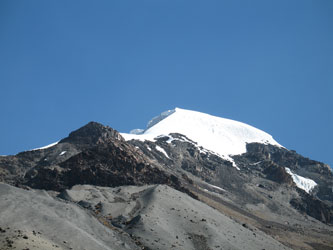 The previous recon hike gave us the route information we would need to take a shot at Nevado Posnansky. We set the alarm for 4:30 and rolled out of the tents at a bit after five. Just getting out of the sleeping was a major task as it had been yet another very cold night. Breakfast was light, rolls and hot tea but more important was just the opportunity to sit in the warm cook tent for a few minutes after yet another freezing night on the permafrost. G took the initiative and left camp a few minutes before I did, starting a long slow hike off in the direction of the big boulder that more or less marked a good spot to turn and head uphill. I followed and caught up with him as we both broke the crest of the first moraine terrace, perhaps one half mile from camp.
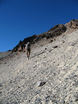 We didn't have to use the boulder as a turning point as the sun was starting to lighten the eastern sky and we ambled along, taking a gently climbing route that led us across frozen moss pillows and a few running rivulets that had not frozen the night before. The water coming from the glacier far above resurged through the moraine fairly low on the slope and we stopped there to shoot a Goo, drink some water and drop the water filter for pick up on the way back down.
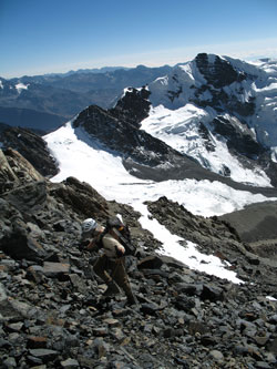 From this point, all we had to do was strike upward for the snow line, but getting there had the promise of being a real death march. We knew from our recon hike that the scree would either be loose enough to cause a day's consternation or alternatively, tight enough to support a footstep. We lucked out and found the later, but the slow slog up the wide couloir was not particularly spellbinding. Climb and climb on was the name of the game and after about an hour we arrived at the top of the scree and intercepted an intermediate snow field. The talus was now loose so we crossed the snowfield to gain some relief before we had to return to the scree and talus for the final couple hundred yards.
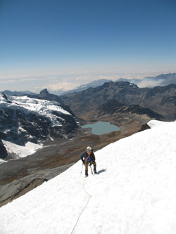 The packs came off at the edge of the snow slope and we gathered the glacier travel gear in preparation for moving onto the ice. The slope turned out to be angled at about 45 degrees and was badly sun cupped but there were no penetientes. We roped up, Chode in the lead, and started moving first for the skyline, where we anticipated we would intercept the ridge proper for the rest of the climb. The sun cups were a major pain as the slope was steep to make the climb the equivalent of working out on a set of stadium steps. We encountered a few cracks in the slope but no crevasses to speak of.
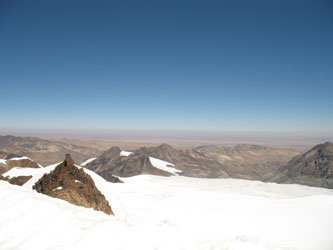 The skyline was in fact the ridge we would take toward the top. The sun was doing its best to heat us up and I soon shed the gloves, the hat, and unzipped to whatever cooling was available. The route continued to be straightforward but for a single crevasse that paralleled the ridge and needed to be crossed via a well frozen blue ice bridge. No issues there and about 10 minutes later the slope angle flattened markedly, becoming an angled bowl, across which we walked to surmount the next slope. The next slope was pleasantly short and when I arrive at the crest, I saw nothing but down on the other side. I cut to the south, perhaps 100 feet, and scored the high point of the ridge, the summit of Nevado Posnansky at ~ 17,810 feet.
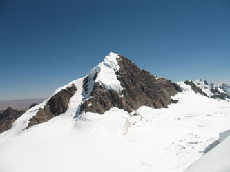 G joined me at the top for a few photos and the view of Cololo as well as the vast glacier/icefield that filled the entire cirque below us, reaching out to the lonesome Alto Plano far below. The Apolobamba spread out before us to the north and south bounded by the Alto Plano on the west and the jagged canyons that fall to the Amazon to the east. The weather was beautiful but neither of us are summit sitters, especially when the heat is doing a job on the snow slopes so it was time to go.
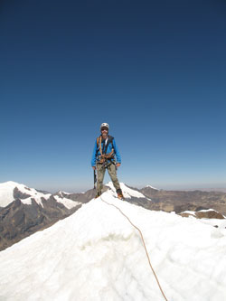 We reversed our course and made our way across the bowl and down the crest of the ridge to the saddle where we had intersected the ridge after the first leg of our climb. Rather than cut left to the base of the ice, we turned right to tag a small sub peak that was within a few minutes walk. This un-named point gave a wonderful view of the Posnansky summit before we retraced our tracks and dropped off the other side of the saddle for the rocks below and a few minute rest before we descended to camp.
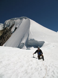 The trip back down the couloir was quick and we noticed tracks the now paralleled our course up the slope. We found later that we had caught the attention of a couple of shepherds who must have been curious as to just what we were up to. We returned to the water pump and after refilling a liter bottle each, we ambled back over the last mile of terrace and moss to the camp.