Argentina 2010
An afternoon's walk to Approach Camp. . . January 11, 2010
(Google Earth Map "Santa Ana to Approach Camp" illustrates the route from Santa Ana to our intermediate camp)
Fernando dropped us off at the Santa Ana gendarme station and soon the bags were whisked off by the arriero to be loaded onto the mules for the first part of the trek to base camp. In the mean time, we had to sign another set of releases, this time absolving the local police force of 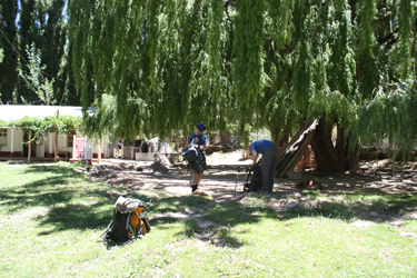 any responsibility for our safety. any responsibility for our safety.
Well . . . that was my read of the document, but my Spanish was not that great and anyway, did we have any choice when they control access to the valley? There was some discussion about our lack of a guide and if my translation was on point, the end result was that we did in fact have guide . . . an invisible ghost guide.
Once the release was signed, we needed only follow the simple directions that Anibal had provided us that morning. "Leave Santa Ana on the right side of the river and go upstream to the last tree . . . then cross the river and walk about 50 yards to a trail . . . take that trail up the valley into the canyon and just past a big grassy area after about 3 miles . . . then go a 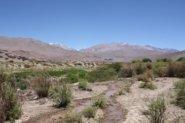 little further, cut across the river and meet the arriero at the Approach Camp. Sounds simple enough and in hindsight . . . the directions are dead on. We walked past the arrieros working to get the gear and the food and other stuff on the mules and crossed over an irrigation ditch or two before making our way up through the last part of the Santa Ana tree area. We hopped from dry patch to dry patch to avoid wet feet as the ditches flood the ground around the last of the grouped trees. little further, cut across the river and meet the arriero at the Approach Camp. Sounds simple enough and in hindsight . . . the directions are dead on. We walked past the arrieros working to get the gear and the food and other stuff on the mules and crossed over an irrigation ditch or two before making our way up through the last part of the Santa Ana tree area. We hopped from dry patch to dry patch to avoid wet feet as the ditches flood the ground around the last of the grouped trees.
Once we left the border post proper, we stayed on the right side and continued to avoid mule dung and mud holes as we meandered along a 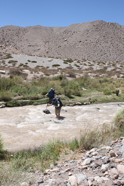 multitude of braided trails leading the half mile or so the the "last tree". There was no real trail so we just aimed for the last tree as we made our way through the low brush and "tailings." Once we reached the last tree (really obvious) we made our first river crossing, using our Tevas or river shoes that we brought along just for that purpose. As an old kayaker, I stick with the advice that so long as the water is not over the knees, you are pretty safe in making a crossing. The river in this case was about 30 feet wide and knee deep. We did not know it at the time but this mid afternoon crossing was tame because the weather had been cool and the glaciers 20 miles up valley had not been heated enough to disgorge the flood of water needed to turn this semi calm river into a rock tumbling waist deep torrent bent on preventing a crossing. multitude of braided trails leading the half mile or so the the "last tree". There was no real trail so we just aimed for the last tree as we made our way through the low brush and "tailings." Once we reached the last tree (really obvious) we made our first river crossing, using our Tevas or river shoes that we brought along just for that purpose. As an old kayaker, I stick with the advice that so long as the water is not over the knees, you are pretty safe in making a crossing. The river in this case was about 30 feet wide and knee deep. We did not know it at the time but this mid afternoon crossing was tame because the weather had been cool and the glaciers 20 miles up valley had not been heated enough to disgorge the flood of water needed to turn this semi calm river into a rock tumbling waist deep torrent bent on preventing a crossing.
We crossed successfully and sat in the sun for a few minutes, letting the feet dry before we put the socks and approach shoes back on to continue on up the valley. Anibal told us to hike about 50 yards to intercept a main trail and we thought we did so but in hindsight, we were just shy of the real trail and therefore doomed to a course of braided herd paths rather 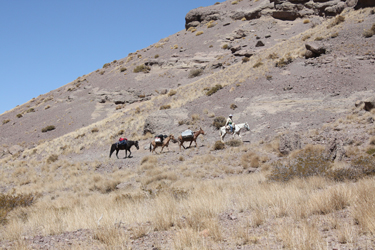 than a trail we could make speed on. Should a reader make this trip, it is important to to note that the lowest part of the valley, i.e. the area closest to the river, has a good number of large rocks and boulders strewn along the floodplain. However when looking to the river there is a point where the boulders and rock thin to few or none. That is where the good trail is. than a trail we could make speed on. Should a reader make this trip, it is important to to note that the lowest part of the valley, i.e. the area closest to the river, has a good number of large rocks and boulders strewn along the floodplain. However when looking to the river there is a point where the boulders and rock thin to few or none. That is where the good trail is.
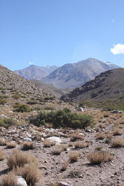
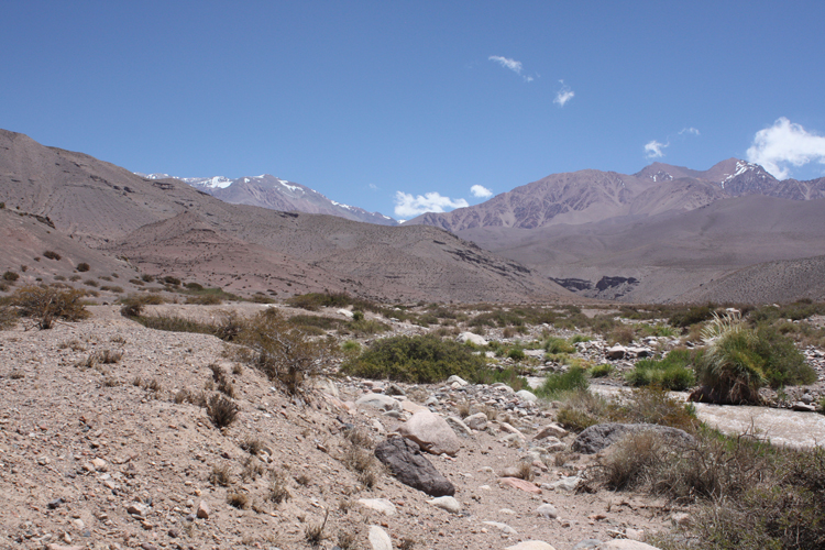
Our failure to score the mule trail left us to make our way on up the floodplain, which is not hard but requires one to connect readily apparent dots through the brush until one covers a mile or more. Once you have some distance under your feet, the sides of the valley begin to converge and the topography 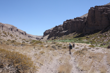 eventually funnels one onto the proper trail. We continued up valley, thankfully on a not too sunny day, as the valley flanks converged and we moved into canyon country proper. The trail was never unclear as it undulated along the left bank, the walls of the cliffs to the left and right becoming more vertical and slowly converging. For the rock enthusiast, there are huge conglomerate boulders to poke at and upon which once should base a vigorous discussion of sedimentary environments. Needless to say, I am not always a popular hiking partner around such stratigraphic storybooks. eventually funnels one onto the proper trail. We continued up valley, thankfully on a not too sunny day, as the valley flanks converged and we moved into canyon country proper. The trail was never unclear as it undulated along the left bank, the walls of the cliffs to the left and right becoming more vertical and slowly converging. For the rock enthusiast, there are huge conglomerate boulders to poke at and upon which once should base a vigorous discussion of sedimentary environments. Needless to say, I am not always a popular hiking partner around such stratigraphic storybooks.
 We covered the better part of the promised three hour hike and came to a large three foot high grassy area, a bit higher up on the left bank, and chose one of the multiple trails through that riverside oasis. Should one repeat our hike, this is just below the rather phallic hoodoo on cliff left. Once through the green zone, we dropped down to the river and walked through some mushy ground, getting the feeling we were really close to our second crossing, which I knew was true when I looked to the far bank and spotted the arriero unloading a mule. Our time was just about dead on the three hour mark as we crossed the river again and hiked up to the camp spot on the right bank. The second crossing was a bit deeper and more challenging as the water was a more swift and the crossing was between two plunge drops . . . but it was still quite negotiable with a pair of hiking poles to assist in the crossing. We covered the better part of the promised three hour hike and came to a large three foot high grassy area, a bit higher up on the left bank, and chose one of the multiple trails through that riverside oasis. Should one repeat our hike, this is just below the rather phallic hoodoo on cliff left. Once through the green zone, we dropped down to the river and walked through some mushy ground, getting the feeling we were really close to our second crossing, which I knew was true when I looked to the far bank and spotted the arriero unloading a mule. Our time was just about dead on the three hour mark as we crossed the river again and hiked up to the camp spot on the right bank. The second crossing was a bit deeper and more challenging as the water was a more swift and the crossing was between two plunge drops . . . but it was still quite negotiable with a pair of hiking poles to assist in the crossing.
The Approach Camp had fresh water and we dropped our packs and re-filled our bottles right from the resurgences that fed a number of six inch wide 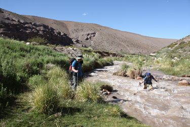 and one foot deep water courses that lead to the river twenty five yards distant. Soon after we arrived, Multi-Presa arrived and advised that Celeste and Manuel were en route from the base camp with a group of four French Canadians who were outbound having climbed from the Pirca de Polacos base camp over the past week. Within minutes Celeste and Manuel arrived and we started to get to know the folks we would be working with over the next ten days or so as we took our turn to score a peak in the Ramada Range. After a bit, the Canadians appeared, having had a very long trip down valley, a bit over 8 hours from the base camp. They had managed to cut the five river crossings down to two but in doing so had to fight the occasional lack of and one foot deep water courses that lead to the river twenty five yards distant. Soon after we arrived, Multi-Presa arrived and advised that Celeste and Manuel were en route from the base camp with a group of four French Canadians who were outbound having climbed from the Pirca de Polacos base camp over the past week. Within minutes Celeste and Manuel arrived and we started to get to know the folks we would be working with over the next ten days or so as we took our turn to score a peak in the Ramada Range. After a bit, the Canadians appeared, having had a very long trip down valley, a bit over 8 hours from the base camp. They had managed to cut the five river crossings down to two but in doing so had to fight the occasional lack of 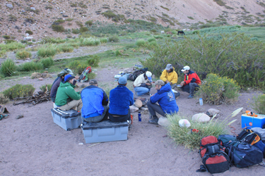 trail and topography that otherwise forced most travelers to make the requisite crossings. trail and topography that otherwise forced most travelers to make the requisite crossings.
After some socializing. we set up the tents and set about our first experience with the mate tea ritual. The mate cup started going around and around while the coals matured for the evening meal. We all took our turn at the bombilla . . . the first of many turns over the next two weeks. The dinner plan was . . . of course . . . beef, lots of it, cooked slowly over a bed of coals and cut into endless portions for all who were interested. Between the 11 people who camped there that evening, I would guess that the better part of 5 or 6 lbs of meat was consumed, all cooked to perfection. We sat around the fire, passed the mate, ate dinner and talked of climbing in French, Spanish, 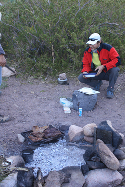 and English, depending upon your position in the circle and the composition of the sub-group at that point in time. There was no segregation but instead a melange of the three languages ebbing and flowing across the group as the evening progressed. and English, depending upon your position in the circle and the composition of the sub-group at that point in time. There was no segregation but instead a melange of the three languages ebbing and flowing across the group as the evening progressed.
By eleven or so, most of the folks had drifted off to a tent somewhere in the brush to get some rest for the next day's hike. The Canadians had a short trip out, we had a long trip up river and the arrieros had a trip up to drop our gear and then a trip all the way back out to deposit the Canadians' gear at Santa Ana. However there was no doubt that it was a great evening beneath the Southern Cross, with good folks . . . and a great start to the climbing portion of the trip.
|
