Mt. Shavano
January 19, 2002 - Mt. Shavano Trail
|
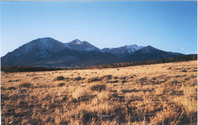
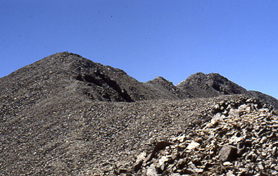
Mt. Shavano as seen from the Arkansas Valley |
We arrived in Salida the night before the climb to check out the roads and find out how close to the two possible trial heads we could drive. We figured we would at least get to Angel of Shavano trailhead and then traverse about 2 miles north on the Colorado Trail to the “Mt Shavano Trail” in Blank Gulch. However, as we approached the peak, we noticed very little snow and instead we drove directly toward the Blank Gulch trailhead. For once, the weather was on our side and we drove all the way to the head of the Mt. Shavano trail, through but 4 inches of snow. Mission accomplished, next stop: dinner in Salida.
We were up early and arrived at the trailhead by 6 a.m. The thermometer was reading a toasty one below zero and with little hesitation; we decided to let the sun come up before heading up the trail. An hour passed and we moved out, encountering just a bit of snow no more than 4 to 6 inches deep. The guidebook indicated that the trail cut might be a bit tough to follow but we encountered no difficulty whatsoever. I should probably not be as nonchalant in my assessment of the ease of following the trail, however between the three of us, we were pushing 120 Fourteener climbs and the route through the lower woods was obvious. After about a mile, we stashed the snowshoes rather than carry them further . . . and as anyone could predict, the untracked snow was soon a foot deep. (Maybe we did not learn as much over the span of those climbs after all.)
|
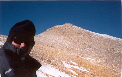
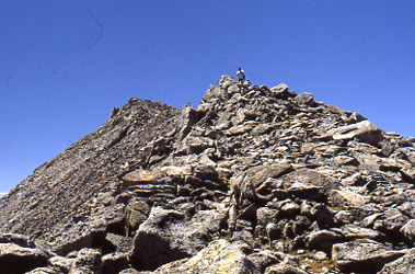
Wind! The summit cone of Shavano rises above the saddle |
Regardless of a bit more snow, we made good time to tree line but promptly lost the trail in deep snow as it turned back on itself near the rocky knob at tree line. Knowing that the trail swept along the southern side of the ridge, we headed directly upslope on rock and snow for a hundred yards and then contoured south until we recovered the trail. So far, it had been a beautiful climbing day; the air was cold but almost still. The trail continues along the side of the ridge, leading toward the outstretched “arm” of the angel snowfield. We approached the angel and though little snow remained on the trial, the wind picked up considerably and was blowing at 50 to 60 mph by the time we reached the saddle below the summit pyramid.
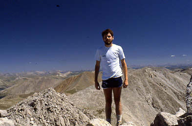
We stopped at the saddle and added layers and facemasks. The wind was blowing hard enough at this point to initiate a brief “turn the climb” discussion but instead we traversed a bit to the east, seeking whatever wind shadow might be available from the summit cone. To our surprise, the terrain cut the wind considerably and forty minutes later, we stood on the summit. Our original plan to continue the climb with a traverse to Tabeguache Peak, however once we took the wind into consideration, we settled for a bite to eat in the lee of some boulders and a retreat to the truck. We made good time back to the trailhead with a round trip time of about eight hours.
Mounts Tabeguache and Shavano
August 10, 1988 - Jennings Creek and Mt. Shavano Trail loop
 Dan, a friend from my Colorado School of Mines tenure, and I found ourselves working at the same company (long story) in Baltimore and in the summer of 1988, we concocted a turbo trip to Colorado to score a few more 14’ers after four year climbing drought. Not that we were not climbing at all, just that we wanted to climb out west again after a stretch of New England and Adirondack climbs. Dan had more vacation time so he flew to Denver five days earlier than I and spent a few days doing a number of solo hikes and climbs in Rocky Mountain National Park. The plan was that I when I arrived in Denver, he would pick me up at the airport and we would climb the living hell out of 14'ers for a long three day weekend before we both headed back to Baltimore. Dan, a friend from my Colorado School of Mines tenure, and I found ourselves working at the same company (long story) in Baltimore and in the summer of 1988, we concocted a turbo trip to Colorado to score a few more 14’ers after four year climbing drought. Not that we were not climbing at all, just that we wanted to climb out west again after a stretch of New England and Adirondack climbs. Dan had more vacation time so he flew to Denver five days earlier than I and spent a few days doing a number of solo hikes and climbs in Rocky Mountain National Park. The plan was that I when I arrived in Denver, he would pick me up at the airport and we would climb the living hell out of 14'ers for a long three day weekend before we both headed back to Baltimore.
 Of course, having climbed all of the 14'ers and reached the age of 48 at this writing, I look back and am amazed that we did as well as we did. We scored two 14'ers on the first day, another on the second, but alas the weather and the effects of fatigue and altitude negated any additional peaks on this trip. Dan met me at the Denver airport about mid day and we made the run to Salida, got some dinner and if I recall correctly, we likely did our shopping at the Safeway in Golden having Safeway deli sandwiches, dinner on the fly. Of course, having climbed all of the 14'ers and reached the age of 48 at this writing, I look back and am amazed that we did as well as we did. We scored two 14'ers on the first day, another on the second, but alas the weather and the effects of fatigue and altitude negated any additional peaks on this trip. Dan met me at the Denver airport about mid day and we made the run to Salida, got some dinner and if I recall correctly, we likely did our shopping at the Safeway in Golden having Safeway deli sandwiches, dinner on the fly.
 We arrived at the Angel of Shavano Campground late that evening and as I look back on it, we drove right in, found an empty spot and made camp for the night. Yes, the Colorado of August 1988 was a bit different than that of today. We pitched Dan's two man tent, put our sleeping bags down on the hard ground and set the alarm "early" as about first light. Our knowledge of the alpine start so that we could be off the summit by noon had not developed at this stage. We were up "early" and tossed our packs in the rental car and were off to the Jennings Creek trail head. I'll take a moment to describe our "packs." as they were a far cry from what I carried the next time I stepped on a 14'er, ten years later. Dan and I did a lot of caving in West Virginia, where the best pack was long, skinny and easily passed We arrived at the Angel of Shavano Campground late that evening and as I look back on it, we drove right in, found an empty spot and made camp for the night. Yes, the Colorado of August 1988 was a bit different than that of today. We pitched Dan's two man tent, put our sleeping bags down on the hard ground and set the alarm "early" as about first light. Our knowledge of the alpine start so that we could be off the summit by noon had not developed at this stage. We were up "early" and tossed our packs in the rental car and were off to the Jennings Creek trail head. I'll take a moment to describe our "packs." as they were a far cry from what I carried the next time I stepped on a 14'er, ten years later. Dan and I did a lot of caving in West Virginia, where the best pack was long, skinny and easily passed 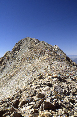 through narrow cave passage. This translated into a Cordurra pack cloth bag, identical to what is now sold as a rope bag for canyoneering. I think we should have gotten a patent as we were perhaps ahead of our time. through narrow cave passage. This translated into a Cordurra pack cloth bag, identical to what is now sold as a rope bag for canyoneering. I think we should have gotten a patent as we were perhaps ahead of our time.
So, imagine a five inch diameter bag about 20 inches long with a draw string on one end, a cloth loop at the other end and a carabiner to connect the two. If you make the draw string the right length , the bag can go over the shoulder, around the waist or be lowered on the end of a sling in a vertical climbing environment. So, into those bags we stuffed whatever food we were going to carry, a map, compass, rain gear, extra layers, and whatever else we were going to carry. Given the 5" diameter x 20" long dimensions, we were traveling pretty light and the thought of carrying extra gear in the event of an injury or night out was not part of the equation. We were young, ambitious and the epitome of Cottoneers.
 We parked at the Jennings Creek trail head at first light plus a bit and made our way up Jennings Creek on obvious trail to about 12,000 feet and then cut cross country to a point just a bit shy of the 14k mark. It was summer and even in '88 climbing 14'ers was a popular weekend pastime, so we were not the only climbers on route. I recall making the high 13k point and then moving along the ridge over a false summit and then on to the summit proper of Tabeguache. The route was classic ridge running traverse with a move here and there to bypass class 3 or steeper ground on our way over to the summit scramble. We might not have climbed in Colorado for a few years, but were in good shape and we made the summit of Tabeguache in a respectable time. We parked at the Jennings Creek trail head at first light plus a bit and made our way up Jennings Creek on obvious trail to about 12,000 feet and then cut cross country to a point just a bit shy of the 14k mark. It was summer and even in '88 climbing 14'ers was a popular weekend pastime, so we were not the only climbers on route. I recall making the high 13k point and then moving along the ridge over a false summit and then on to the summit proper of Tabeguache. The route was classic ridge running traverse with a move here and there to bypass class 3 or steeper ground on our way over to the summit scramble. We might not have climbed in Colorado for a few years, but were in good shape and we made the summit of Tabeguache in a respectable time.
 We snacked atop Tabeguache and were then off across the ridge line to the summit of Mt. Shavano. It is a good distance between the two peaks with some elevation lost and gained along the way. This was early in my 14'er climbing career and as I look back, I probably should have had storms on the mind but we were clad in cotton and damn well going to connect to the far summit. And . . . we did, scrambling here and there to overcome the occasional class 2+ bump along the way. Soon enough we, we were atop Mt. Shavano, our second 14'er summit of the day. However, we made the decision not to cross back to Tabeguache but instead to drop off Shavano via the Mount Shavano trail. We were Cottoneers but we were not total fools, so we knew better than to consider McCoy Gulch as our exit. We snacked atop Tabeguache and were then off across the ridge line to the summit of Mt. Shavano. It is a good distance between the two peaks with some elevation lost and gained along the way. This was early in my 14'er climbing career and as I look back, I probably should have had storms on the mind but we were clad in cotton and damn well going to connect to the far summit. And . . . we did, scrambling here and there to overcome the occasional class 2+ bump along the way. Soon enough we, we were atop Mt. Shavano, our second 14'er summit of the day. However, we made the decision not to cross back to Tabeguache but instead to drop off Shavano via the Mount Shavano trail. We were Cottoneers but we were not total fools, so we knew better than to consider McCoy Gulch as our exit.
 Looking at our 7-½ minute quad (yes, we really did have map), we saw that we could take the Mount Shavano trail down to the Blank Gulch trail head and then cut across the base of Shavano to the Angel of Shavano trail head, on what I believe today is a leg of the Colorado trail. That was the plan and soon enough we were off on our downhill escapade, giving little thought to the fact that the Blank Gulch trail head is a good ways from where our car was parked at the Denny Gulch trail head. We made the hike to the Blank Gulch trail head head and then girded ourselves for the walk along the base of the mountain to get back to the road that would lead in no short distance to our ride. We started hoofing it in the direction of the road and broke out onto the track at or around the Angel of Shavano trail head. Now we were just four miles short of our car. Looking at our 7-½ minute quad (yes, we really did have map), we saw that we could take the Mount Shavano trail down to the Blank Gulch trail head and then cut across the base of Shavano to the Angel of Shavano trail head, on what I believe today is a leg of the Colorado trail. That was the plan and soon enough we were off on our downhill escapade, giving little thought to the fact that the Blank Gulch trail head is a good ways from where our car was parked at the Denny Gulch trail head. We made the hike to the Blank Gulch trail head head and then girded ourselves for the walk along the base of the mountain to get back to the road that would lead in no short distance to our ride. We started hoofing it in the direction of the road and broke out onto the track at or around the Angel of Shavano trail head. Now we were just four miles short of our car.
 We were dead tired so we put a thumb in the air and put our faith in the drivers of Colorado as we knew them to be in our college days. Our assumption of their generosity proved unerring and the first passing pick-up solved our need for transport, obviating four miles of ascending road march that would have really hurt . . . I mean really hurt. Given that we clinched this double climb within 24 hours of my arrival from sea level, we were feeling good about ourselves that evening. The hindsight of many more climbs tells me we were really lucky Cottoneers who but for having a 7.5 minute map, good weather, and generous traffic, would have counted our decision not to re-traverse to Tabeguache as likely the most stupid move of the trip. We were dead tired so we put a thumb in the air and put our faith in the drivers of Colorado as we knew them to be in our college days. Our assumption of their generosity proved unerring and the first passing pick-up solved our need for transport, obviating four miles of ascending road march that would have really hurt . . . I mean really hurt. Given that we clinched this double climb within 24 hours of my arrival from sea level, we were feeling good about ourselves that evening. The hindsight of many more climbs tells me we were really lucky Cottoneers who but for having a 7.5 minute map, good weather, and generous traffic, would have counted our decision not to re-traverse to Tabeguache as likely the most stupid move of the trip.
|
