|
||||||||||||||||
|---|---|---|---|---|---|---|---|---|---|---|---|---|---|---|---|---|
Chopicalqui - Millisraju ExpeditionChopicalqui Base CampJuly 4, 2005 – Huaraz to Chopi Base Camp
The trip to the Chopi base camp did not have to start at 0 dark 30 as we only had to ride three hours from Huaraz to the Chopi trailhead in the Llanganuco Valley and then hike just 30 minutes to the Chopi base camp (map). The short hike to the base camp finally provided us with something we were really looking forward to . . . the opportunity to sleep in before getting a hot breakfast and then moving out in the late morning. Keeping Elias and Joaquin in the stable until 10 a.m. was no easy task as they are accustomed to an early start to a full day. Regardless, our two gringo bodies needed a bit of rest before we took to the hills.
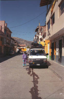
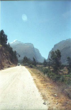
We took full advantage of the nearby breakfast opportunity offered by Chris’ Café Andino and both of us had a hearty meal to start off our day. Like I noted earlier, I have no business connection with Chris other than being a very satisfied customer and a good breakfast at his Café just piled added to our satisfaction. We finished breakfast and then went on down to meet the crew at the front door where the obligatory white Toyota van waited our arrival. The gear was all inside the Mesa lodging hallway and the four of us started passing gear out the door and up onto the top of the van for the familiar ride to the Llanganuco valley trailhead. We left Huaraz and wended our way through the start of another hustle and bustle day to the main road leading out of town. We knew the route from the year before as the drop off point for Chopi is just a bit beyond the Pisco drop point. The route heads north, heading toward the looming mass of the Huascaran massif as well as an occasional peak at Chopicalqui, a spur peak of Huascaran. As veterans of a prior trip to the Cordillera Blanca, we started to recognize some of the other Cordillera valleys and notable peaks as we cruised north. We caught glimpses of Copa and the peaks of the Ischinca that we likely saw last year but did not recognize as 6000-meter peaks. We turned off the main road at Yungay and began the slow trip up the dirt road leading up to Huascaran National Park. Our driver added to the experience by taking a slight detour through a couple of rutted farm fields, a real “aventura” as the driver said. Each driver has his own method and generally some degree of madness, this ride was no exception.
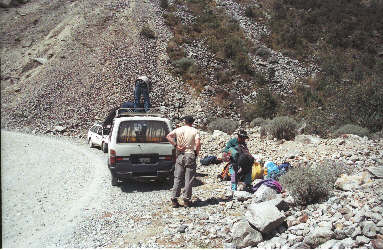
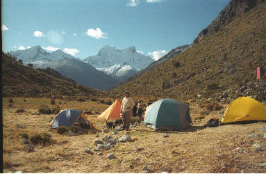
We stopped at the warden’s hut and obtained our park passes before continuing through more switchbacks before arriving at the beautiful Llanganuco lakes. We continued the drive past the Pisco trailhead and then switched back and forth a few more times to reach the hairpin curve that widens to allow vans to drop climbers and gear at the Chopi trailhead. We pulled to the side and offloaded the gear that would, after a series of carries, make its way to either the moraine camp or the high camp, about 4500 feet above our drop off point. Our move from the road to the base camp would require about 6 man loads and there were four of us. I drew the short straw and got to sit tight and guard the gear while the G, Joaquin and Elias made the first carry of the trip to the base camp ½ hour away.
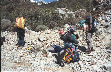
Joaquin and Elias returned about an hour later and the three of us hefted the remaining gear for the hike up to the base camp. The route is a clear and gently graded trail leading to a lightly wooded flat spot located at about 14,000 feet. The route to the camp crosses some boggy ground just before you arrive but then yields to firmer turf suitable for pitching tents. The camp area is not very large and if there are a number of groups, your tents will end up fairly closely quartered. When we were there, there was just one other group, leaving plenty of room for us to find a dry ground for our tents. Our camp included a tent for Gary, another for me, a shared tent for Elias and Joaquin, and a Mountain Hardwear Kiva for cooking and eating. The Kiva was much smaller than the large pyramid tent we had last year but since we were man hauling all the gear to the upper camps, the scope of outfitting was reduced accordingly. Chopi is a non-burro climb and one has to either lug the gear up oneself or acquire help to get the gear up the hill. The idea was that Joaquin and Elias would make multiple trips to get the loads up the moraine but as with any game plan, things were soon to change. The idea was to cull portions of the camp with each rise in elevation so that Gary, myself, and Joaquin, could do the final haul to the high camp in one move.
Once the tents were pitched Elias bailed into the afternoon snack and then, while we ate crackers covered with peanut butter, he set about making dinner. Elias is a professional in the cooking department and he leaves no doubt of two things from the very start, the food would be good and we did not have to worry about getting sick but for our own devices. Dinner was ready soon enough and everyone had his fill. I have no idea what we ate on a daily basis but it was always fresh and hot. By the close of dinner, the sun had set and we took to looking at stars not available to us in the Northern Hemisphere. The Cruz de Sur (Southern Cross) appeared over the summit of Huascaran to the south while to the North, the big dipper came into view atop the summit of Pisco. For stargazers, the night sky in Peru is incredible and we were in no hurry to head for the tents that first night on the mountain.
July 5, 2005 – Introduction to the Chopi Moraine
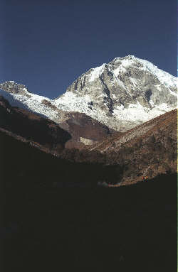
Last year’s climb of Pisco introduced us to a whole new kind of moraine. Our prior experience in Canada was with lesser and perhaps more friendly moraines as compared to those we found in Peru. The Peruvian version is different; it is alive and can easily take a bite out of the unwary climber. We awoke before the sun arrived at our camp but played it smart by lying in until the sun hit almost made it to the tents. The night was cold and even though Elias had hot water for tea all ready, I just was not ready to bail out into the morning frost without some promise of direct sunshine. We sat in the Kiva and sipped tea, watching the sun visibly creep down the flank of the moraine forming the west side of the valley in which the base camp is located. We formulated our plan for the day, which called for a hike up to the moraine camp, both to begin the acclimatization process and to relieve the boredom associated with getting acclimatized to a higher elevation. We knew we could not, or better phrased, should not, rush the acclimatization process but when all you can see are blue skies and your prior year was a constant barrage of poor weather, it is tough to wait out the production of red blood cells.
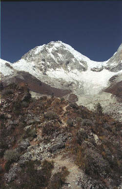
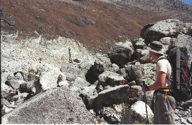
Our game plan called for a hike up the moraine (map) to the next camp and a return to the base camp for a low elevation night. Since most of the climbing gear had to make it up the mountain sooner or later, we also picked out assorted items to drop at the higher camp. Not a lot of weight but every pound spread out over successive climbs of the moraine could only help. We set off with the famous Elias “box lunch” and walked to the trail at the west side of the camp. An obvious path leaves the valley floor and makes its way steeply to the skyline of the lowest moraine. The first steps after traveling to a far-flung range are always hard and the first pitch is steep, rocky, and rutted. However, once atop, you walk a mostly level path along the top of the lateral moraine to its terminal point. The moraine you have traveled separates two glacial flow paths so that at the end you drop onto a lower and now active part of the moraine. Like the moraine on Pisco, you realize that you are crossing a dirty glacier with a thick topcoat ranging from boulders to grit. We did not see any movement like last year but there was little doubt that there is action beneath the feet. We crossed the dirty ice on the easily discernable trail and took to the steeply ascending trail that seeks to quickly regain every foot of altitude lost in the crossing.
After you regain the crest of the higher lateral moraine, the grade lessens markedly but now traverses right along the edge of the gouged out side of the ridge. One false step or an unexpected gust of wind from the west will send you on a one-way trip to the glacier about 200 feet below. This portion of the trail may be light on grade but leaves nothing to the imagination with regard to exposure. Once beyond the exposed portion, the trail again climbs steeply and without relief before finally reaching the base of the high wall just below the Kinzl glacier. The moraine camp is located beneath this head wall where there are sufficient tent pads to allow at least a half dozen groups with a few tents each to find a spot for the night. We only carried light loads so our visit was brief as we dropped gear drop and then descended to the base camp, 3000 feet below. We arrived at base camp an hour and a half after leaving the moraine camp and were greeted by Elias with a mid afternoon snack. We snacked while he swarmed about the evening meal and by the time we all finished dinner, the sun was setting mode and the stars were coming out. It is tough to call it a day a bit after 6 in the evening but it was a productive day and we had a bit of work planned for the next morning. |
