Thunder Pyramid
May 20, 2012 - White Gully
There are some climbs that are snow climbs, literally by definition, do them in the wrong season and risk a rock hit, tottering piles of cruddy choss, or the risk of taking a flyer. I've always put 14'er Little Bear in that category and I hold the same opinion for Centennial Thunder Pyramid. I considered a shot at the peak in the event our Spring San Juans trip to Dallas and Teakettle fell through but as we did go south, a few weeks had to pass before I got my shot at Thunder Pyramid . . . on snow.
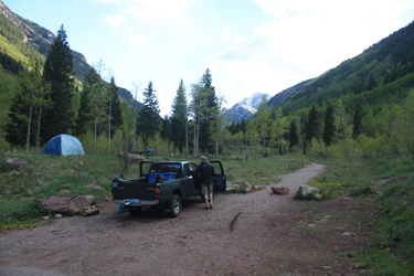 We left Cheyenne mid morning to get to Aspen with enough light to hike into a camp spot on the far side of Crater Lake. Traffic was nil and by 4 pm we were at the trailhead, having also found that valley campgrounds were much more empty than full. We were faced with a decision, hike in and eat cold cuts on bagels for dinner and be at least 2 miles closer to the start of the climb in the morning or go to the Hickory House, eat ribs and camp at the trailhead so we could hike two extra miles and have to get up no later than 3 am. The debate was short . . . we pulled out of the parking lot to made our way into town for ribs. We left Cheyenne mid morning to get to Aspen with enough light to hike into a camp spot on the far side of Crater Lake. Traffic was nil and by 4 pm we were at the trailhead, having also found that valley campgrounds were much more empty than full. We were faced with a decision, hike in and eat cold cuts on bagels for dinner and be at least 2 miles closer to the start of the climb in the morning or go to the Hickory House, eat ribs and camp at the trailhead so we could hike two extra miles and have to get up no later than 3 am. The debate was short . . . we pulled out of the parking lot to made our way into town for ribs.
 The chow was good and by 7:30 we had the tent up, the air mattresses inflated and the sleeping bags a loftin'. I was out by 8 pm, knowing the 2 am would come soon enough. The alarm went off, and we were soon breaking down the tent and digging into the Entenman's chocolate donuts that go with every "old school" climb that we do. Some old traditions serve to define the climb, that burst of what is probably the worst possible breakfast before a climb is just what we wanted and needed to put one foot in front of the other . . . you gotta love those things. The chow was good and by 7:30 we had the tent up, the air mattresses inflated and the sleeping bags a loftin'. I was out by 8 pm, knowing the 2 am would come soon enough. The alarm went off, and we were soon breaking down the tent and digging into the Entenman's chocolate donuts that go with every "old school" climb that we do. Some old traditions serve to define the climb, that burst of what is probably the worst possible breakfast before a climb is just what we wanted and needed to put one foot in front of the other . . . you gotta love those things.
 We passed Maroon Lake and the Deadly Bells sign and made our way on up and over the land slide that gives Crater lake its reason for being. Chat was lively, our usual conversation . . . dreams of leading a troupe of midgets on a nationwide wrestling tour, comparing the character of the Bolivian vs. Peruvian massages that follow South American climbs and all those other topics that two guys talk of at 4 am but would generally not share with dinner company. We passed Crater Lake then went up and over a snowfield that covered the trail from the base of the climb up to the Bell Cord and then we dropped back down onto the West Maroon Creek trail, making our way to the creek crossing that marks the cut off to the South Bell's summer route and the opposite side detour to the start of the climb up Thunder Pyramid. We passed Maroon Lake and the Deadly Bells sign and made our way on up and over the land slide that gives Crater lake its reason for being. Chat was lively, our usual conversation . . . dreams of leading a troupe of midgets on a nationwide wrestling tour, comparing the character of the Bolivian vs. Peruvian massages that follow South American climbs and all those other topics that two guys talk of at 4 am but would generally not share with dinner company. We passed Crater Lake then went up and over a snowfield that covered the trail from the base of the climb up to the Bell Cord and then we dropped back down onto the West Maroon Creek trail, making our way to the creek crossing that marks the cut off to the South Bell's summer route and the opposite side detour to the start of the climb up Thunder Pyramid.
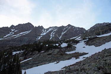
 We cut left when we spotted a break in the willows and made our way to an obvious gap in the lower cliff band that appeared to yield a route upward. It turned out to be a sucker trap, replete with an icy class 4 pitch so we backed off and moved to the next slot, a much better choice. This time we broke the cliff band after crossing a bit of very hard neve and then working our way up through talus to a flat before the next cliff band. The break in the next band was really obvious and soon we were crossing the lower reaches of the Shoemaker Basin on our way to the base of a snow line that we knew from online trip reports would provide a crampon cruise nearly to the summit. We cut left when we spotted a break in the willows and made our way to an obvious gap in the lower cliff band that appeared to yield a route upward. It turned out to be a sucker trap, replete with an icy class 4 pitch so we backed off and moved to the next slot, a much better choice. This time we broke the cliff band after crossing a bit of very hard neve and then working our way up through talus to a flat before the next cliff band. The break in the next band was really obvious and soon we were crossing the lower reaches of the Shoemaker Basin on our way to the base of a snow line that we knew from online trip reports would provide a crampon cruise nearly to the summit.
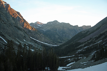
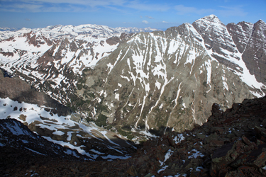 We made our way up a bit of a sloping ramp before crossing a last snowfield before stepping our way up through a weakness in the cliffs just below the start of the snow. The weakness gave us access to grassy slopes that, after moving left, we chose to continue to climb for another 100 feet before stopping to put on the crampons for the snowy climb portion of the ascent The snow was hard, good hard neve that required use of both crampons and ice axe to climb safely. It was still early, about 7 am and the sunlight hitting the top of the Bells was still hours away from warming the slopes we were climbing. The slope probably averaged 30 to 35 degrees and after the better part of 800 to 1000 feet of climbing, we reached the point where a shallow couloir and snow line branched to the right. We had a choice to make. We made our way up a bit of a sloping ramp before crossing a last snowfield before stepping our way up through a weakness in the cliffs just below the start of the snow. The weakness gave us access to grassy slopes that, after moving left, we chose to continue to climb for another 100 feet before stopping to put on the crampons for the snowy climb portion of the ascent The snow was hard, good hard neve that required use of both crampons and ice axe to climb safely. It was still early, about 7 am and the sunlight hitting the top of the Bells was still hours away from warming the slopes we were climbing. The slope probably averaged 30 to 35 degrees and after the better part of 800 to 1000 feet of climbing, we reached the point where a shallow couloir and snow line branched to the right. We had a choice to make.
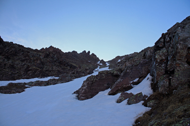
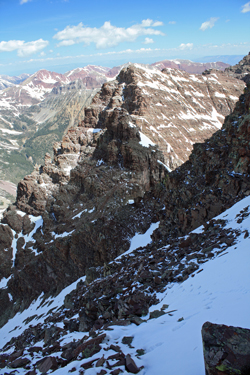 The online trip reports showed folks climbing to the right but we opted to go straight up to a break in the ridge. I had gone to the trouble of printing out an excellent trip report from just two weeks earlier but for all my diligence in remembering to print and bring the report to our camp, I did manage to leave it in the truck when we left at 3 am. We knew the other group cut right but to be honest, we were both a bit tired in the ankles and I was ready to trade the snow for a bit of scree and talus, even with the sure knowledge that it would be loose. The online trip reports showed folks climbing to the right but we opted to go straight up to a break in the ridge. I had gone to the trouble of printing out an excellent trip report from just two weeks earlier but for all my diligence in remembering to print and bring the report to our camp, I did manage to leave it in the truck when we left at 3 am. We knew the other group cut right but to be honest, we were both a bit tired in the ankles and I was ready to trade the snow for a bit of scree and talus, even with the sure knowledge that it would be loose.
Our last 200 feet to the summit were on slidy talus and scree but taking it one step at a time and with a good set of hiking poles, it was really not that bad at all. We broke the ridge line and were a bit perplexed, go right or left? I was sure it was go left so we headed off in that direction but soon the clear route petered out to a snow covered section of cliff with little signs of any traffic. After expending 15 minutes to head left, we came back to the gap and opted for the other direction. Bingo! traffic . . . a cairn here and there, not lots of traffic but enough to know the were now on route. We climbed and traversed, cutting back and forth a bit, before coming to the ridge proper and working our way to the highest point. We had summitted Thunder Pyramid.
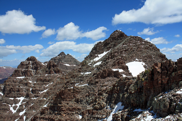
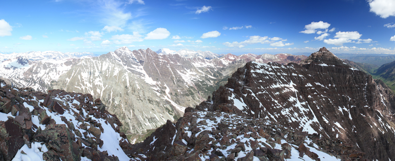
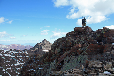 The views from the top of this peak are some of the best I've ever had in Colorado. One can take in the whole of the Elk Range, from the snow covered mass of Capitol to the red ledges of Pyramid and the Bells, covered with snow in many places. Standing atop this ridge gave me a healthy respect for a fellow that I've climbed with who had once traversed the length of this ridge, seriously that is a solid accomplishment. We had no wind so we stopped for a bite to eat, made the gummy worm offering to Pachamama in hopes of a safe descent, and then set off. In lieu of going down exactly as we had come up, we headed toward Pt. 13,722 to take a look at how hard the connecting ridge would be and, at the very least, intercept the continuous snow line that had attracted the attention of those who had elected it as an ascent route. The views from the top of this peak are some of the best I've ever had in Colorado. One can take in the whole of the Elk Range, from the snow covered mass of Capitol to the red ledges of Pyramid and the Bells, covered with snow in many places. Standing atop this ridge gave me a healthy respect for a fellow that I've climbed with who had once traversed the length of this ridge, seriously that is a solid accomplishment. We had no wind so we stopped for a bite to eat, made the gummy worm offering to Pachamama in hopes of a safe descent, and then set off. In lieu of going down exactly as we had come up, we headed toward Pt. 13,722 to take a look at how hard the connecting ridge would be and, at the very least, intercept the continuous snow line that had attracted the attention of those who had elected it as an ascent route.
We went perhaps .20 miles before hitting an intermediate point and opting not to go for the connecting ridge. We cut back to the snow line and found that our hour of summit dawdling and the bit of ridge traverse we did had accomplished the goal we really had in mind . . . killing just enough time for the snow to soften enough to take a good heel plunging step. We were onto the snow, hitting some hard spots here and there, and actually being surprised that the snow was getting more challenging as we lost elevation. By the time I got to the bottom, I had two ice axe arrests in the bag, nothing major but a brief opportunity to confirm that my muscle memory was ready for action.
We exited the snow and retraced our route to the cliff breaks and then on back to the trail in the base of the valley. The water pump was stashed at the stream crossing so after taking a rest, we filled water bottles and a bladder and then left for the trailhead, stopping a time or two en route to take in the views as we brought a 13 hour day to a close.
|
