|
|---|
McHenry's PeakJuly, 2006 - Glacier Gorge/Stone Man Pass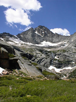
Glacier Gorge is generally synonymous with a long ski but this day would be different . . . we weren't going to ski . . . we would walk up the gorge. Our destination was not a sure thing but we had decided that we would most likely climb the "Trough" route on Longs Peak to finish what had not been an especially successful training season in preparation for our upcoming trip to Bolivia's Apolobamba. The Trough promised a long hike and lots of work for the legs and good practice for ice axe and crampon technique. The only question was were we too late for the Trough, meaning did the snowfield still reach all the way down to the floor of the Gorge?
The class 2 climb was accomplished by simply choosing one of the myriad of braided climber's paths that led up to the first snowfield crossing. The snow was still hard that morning so the main concern was a long slide and I do mean a long one. The remaining snow lay in a shallow couloir and a slip would have meant a many hundred foot run out to the flatter but boulder studded terrain far below. We crossed the 25 feet of snow with the ice axes ready and some very well kicked steps. The route was obvious not by means of trail or cairns but by the presence of an upward sloping ledge that appeared to lead to a pinnacle and path through the steeper ground. We took the ledge to the point where the course curved around out of sight and found both a cairn and worn lichens, indicating that we were not the first to accept the invitation.
The tourists had made it to Black Lake by mid afternoon and we played through a group here and there as we beat feet for Mills Lake, the now familiar climber's cut off trail, and the truck. McHenry's turned out to be a good alternative to the Trough and though the snow climbing portion was abbreviated by the late season, the near technical terrain made for fun scrambling to the summit.
|

 We left a bit on the late side but still before the sun was up. We knew the Trough would be in the shade but having descended from the summit of Meeker a few years before and an hour too late, I knew the price for sleeping in was the torment of postholing across any exposed snow fields. We took the Mills Lake cutoff, shaved 1/2 hour off the trip to Mills and were on our way to Black Lake, about 4 miles or so above the trail head. There was little snow left in the lower reaches of the Gorge so the trip to Black Lake was a slush free/dry boot hike.
 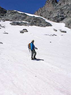 We kicked our way up the snow remaining on the short highwall below Black Lake and cut left around the lake to the ramp leading to the upper most reaches of Glacier Gorge. The Trough route to the summit of Longs is visible for miles as a sinuous snow path leading to the summit block but you cannot see just how far down the couloir the snow comes until you climb nearly to the mouth of the couloir. We did and found to our disappointment that we were about two weeks too late for the Trough. The start of the climb was dry as a bone and promised to be a scree struggle instead of a crampon cruise. We turned to the opposite side of the valley and McHenry's Peak.
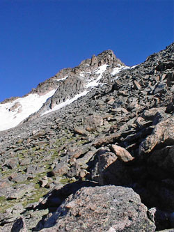 We had looked at McHenry's as a "must do" climb since we made our first winter attempt on Pagoda Peak, a number of years before. We had skinned to the upper Gorge hoping for a winter ascent but found an avalanche slope just asking for trouble . . . off we went toward to Pagoda. We came back in the Spring and found a huge cornice hanging over the east facing ramp route we wanted to climb . . . off we went toward Chiefshead. This time we saw smooth Spring snow slopes leading to Stone Man Pass and knew that this would be the day to give McHenry's our best shot.
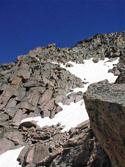 We crossed the glacier scoured terrain atop Black Lake, passing a number of cow elk bedded down in the grassy flats between boulders. We came to a perched lake that we were able to cross via a solid ice/snow bridge covering its narrow rocky outlet. We climbed up the steep granite slope on the opposite side and trudged over the rolling rocky terrain between us and the snowfield that would give us a route to Stone Man Pass. We took a Goo break at the edge of the snow and broke out the crampons for the flat and then steep traverse of the snow leading to the pass. There was no need to rope up as the snow was giving great purchase to our crampons and would present little resistance in the event one of us needed to arrest a fall.
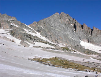
 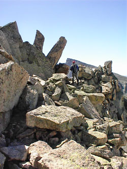 Once we reached the top of the pass, we were able to see most of the remainder of the route to the summit. We knew from others that the terrain would be 3rd and 4th class for at least a portion of the route as McHenry's is considered to be the most challenging non-technical peak in Rocky Mountain Park. From the top of the pass, we could see that we would have class 2 terrain for about half the remaining climb and then we would have to cross some steep snow and find a route up through a series pf palisades and large boulder piles to reach the summit.
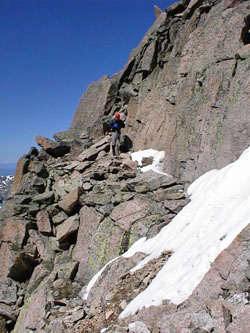 Once around the pinnacle, the path lead upward along a series of sloped ledges to the boulder pile that protects the summit proper. We climbed and continued to traverse around in a westerly trend to find an acceptable class 3/4 route up to the summit. We kept climbing and traversing clockwise and soon entered another couloir that provided more 3/4 climbing to the summit proper. The view of glacier gorge is precipitous to say the least but worth the ascent. We took time for a quick bite, something to drink and a look at the summit register. There had been a few other people on the peak that summer but no more than a half a dozen had signed the register by early July.
 We retraced our ascent and picked our way down through the steep terrain, finding the first couple hundred feet of drop the most challenging. The steep snow that we crossed was now soft from the afternoon sun and our steps became the starting points for our post holes on retreat. We were soon across safely and dropped down through the talus to the top of Stone Man Pass. The route from Stone Man to the head of Glacier Gorge was all snow and we easily heel stepped our way down the steep section and across the flat portion to the granite that formed the toe of the slope. Off came the crampons and we began our hike back around the headlands and down the ramp to Black Lake.