Argentina 2010
Climb to La Vitrola Camp . . . January 14, 2010
(See Google Earth photo route for Base Camp to La Vitrola Camp)
The plan called for a rest day and then a move to our first camp en route to the summit of La Ramada. Manuel had portered loads as high as 17,000 ft. on Ramada and said that the climbing time to the La Lagunita camp, at about 14k, would be about 4 hours and another hour and change would be needed if we wished to climb to the La Vitrola camp, at a bit over 15k. We knew we were climbing to a high camp but which one would be a matter of where water could be found.
 We gathered our gear and Manuel parceled out the food and cooking gear for the four of us to cover 4 nights on the mountain. We figured this would provide a climb to the first camp, climb to a next higher camp, a day of rest/acclimatization at one of the camps, a summit day and a sparse food second summit attempt. Everyone loaded up their packs with their own gear, the group camping gear and the kitchen/food allotments. The weather was warm and G and I were grousing about where to attach those damn double plastic boots to the already heavy packs. We were going to start this climb in approach shoes and if the weather held out, we figured we would hike all but the summit day sans plastic boots. Little did we know . . . We gathered our gear and Manuel parceled out the food and cooking gear for the four of us to cover 4 nights on the mountain. We figured this would provide a climb to the first camp, climb to a next higher camp, a day of rest/acclimatization at one of the camps, a summit day and a sparse food second summit attempt. Everyone loaded up their packs with their own gear, the group camping gear and the kitchen/food allotments. The weather was warm and G and I were grousing about where to attach those damn double plastic boots to the already heavy packs. We were going to start this climb in approach shoes and if the weather held out, we figured we would hike all but the summit day sans plastic boots. Little did we know . . .
We left camp at about 9 a.m., heading out on the clear trail that leads along the bank above the river plain for about a half mile. The trail rises gradually for that half mile and then starts to climb into the higher Valle Superior. The trail meanders up a red hill until it meets the cut that drains the flow from the Italian Glacier on La Mesa. The trail then steepened and when we got to the talus slope generated by the cliffs 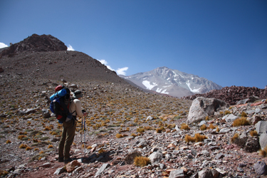 to our left, the trail really steepened as it bypassed the boulder field known as Piedras Coloradas. We stuck with the climbing trail rather than shortcutting to the boulders and having to find a course through the truck size rocks. Our course took us to the juncture of the boulder field and the talus slope where we dropped through a short series of gaps in the boulders and exited into a small depression that is the terminus of the Valle Superior. to our left, the trail really steepened as it bypassed the boulder field known as Piedras Coloradas. We stuck with the climbing trail rather than shortcutting to the boulders and having to find a course through the truck size rocks. Our course took us to the juncture of the boulder field and the talus slope where we dropped through a short series of gaps in the boulders and exited into a small depression that is the terminus of the Valle Superior.
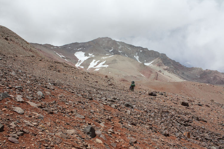
The depression opens up into the valley proper, which is another alluvium filled valley, this time blocked by the boulders and a few hillocks. We walked across the flat expanse, looking for an obvious course that would take us up the ridge where our first camp would be located. The 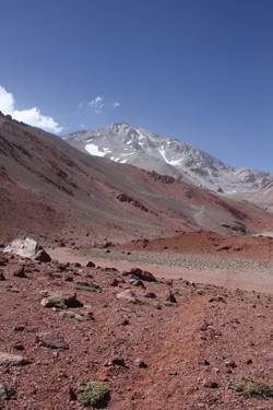 most obvious feature of the valley is a 15 foot drop from the upper gravel terrace one arrives on to a lower terrace, down onto which we dropped to continued our course up valley. I knew where the La Lagunita camp was as far as "its up there" from a good set of GPS points provided by Anibal and we had plotted these points on our Google Earth photo sheets. We soon realized that going any further up the Valle Superior was not getting us closer to our goal. I also had some intermediate way points for trail segments and we were diverging from them as well. most obvious feature of the valley is a 15 foot drop from the upper gravel terrace one arrives on to a lower terrace, down onto which we dropped to continued our course up valley. I knew where the La Lagunita camp was as far as "its up there" from a good set of GPS points provided by Anibal and we had plotted these points on our Google Earth photo sheets. We soon realized that going any further up the Valle Superior was not getting us closer to our goal. I also had some intermediate way points for trail segments and we were diverging from them as well.
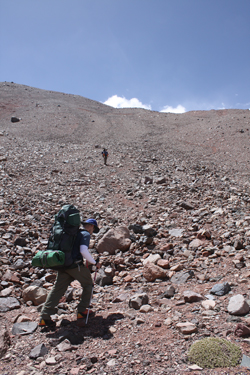 We made a 180 degree turn and surmised where the "trail" was. We know from prior trips that, in the Andes, the word "trail" has many meanings . . . a climber's trail . . . a pack trail . . . or the most prevalent option, the braided guanaco - llama - alpaca - vicuna trail that meanders all over any given valley or hillside. Regardless, we knew that we had to get into the neighborhood of a red outcrop on the ridge well above us so we took on a shallow couloir that seemed to be only semi filled with scree. We each chose our own paths and gained about 500 feet of elevation before the couloir started to hook to the right, albeit gently, and became filled with more talus than scree. That was a good change as I hate scree. Better yet, after another 100 yards or so we hit a solid trail segment that looked to go right to the outcrop we were aiming for and so it did. We made a 180 degree turn and surmised where the "trail" was. We know from prior trips that, in the Andes, the word "trail" has many meanings . . . a climber's trail . . . a pack trail . . . or the most prevalent option, the braided guanaco - llama - alpaca - vicuna trail that meanders all over any given valley or hillside. Regardless, we knew that we had to get into the neighborhood of a red outcrop on the ridge well above us so we took on a shallow couloir that seemed to be only semi filled with scree. We each chose our own paths and gained about 500 feet of elevation before the couloir started to hook to the right, albeit gently, and became filled with more talus than scree. That was a good change as I hate scree. Better yet, after another 100 yards or so we hit a solid trail segment that looked to go right to the outcrop we were aiming for and so it did.
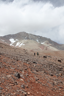 We climbed steadily up to the outcrop and then stopped for a short break. Our base camp was at about 11,850 ft. and we were now up to about 13,400 ft., heading for La Lagunita camp at about 14,050. The route from the red outcrop skirted the slope while climbing steadily as we knew from the GPS that we only had to gain about 650 feet and cover a bit less than 3/4 mile to get to the first camp. There was a solid trail at this point and we climbed slowly but steadily to the camp, not in any hurry to spend any more energy than necessary as we did not know for sure if the La Lagunita Camp would have the one thing we needed to find . . . water. Within 45 minutes the trail took a sharp left turn and we had arrived a La Lagunita. For the non Spanish speaking reader, the name translates into Little Lake Camp and for us on that day . . . it was Little Dry Lake Camp . . . the shallow depression that obviously holds water earlier in the season was bone dry. We climbed steadily up to the outcrop and then stopped for a short break. Our base camp was at about 11,850 ft. and we were now up to about 13,400 ft., heading for La Lagunita camp at about 14,050. The route from the red outcrop skirted the slope while climbing steadily as we knew from the GPS that we only had to gain about 650 feet and cover a bit less than 3/4 mile to get to the first camp. There was a solid trail at this point and we climbed slowly but steadily to the camp, not in any hurry to spend any more energy than necessary as we did not know for sure if the La Lagunita Camp would have the one thing we needed to find . . . water. Within 45 minutes the trail took a sharp left turn and we had arrived a La Lagunita. For the non Spanish speaking reader, the name translates into Little Lake Camp and for us on that day . . . it was Little Dry Lake Camp . . . the shallow depression that obviously holds water earlier in the season was bone dry.
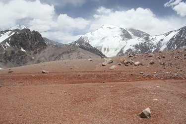 We looked around the area to see if there was a nearby snow or penitente field that we could use as a water source but there was nothing to be found. Had there been water, we would have stopped here as there was plenty of flat ground for the tents and the camp is located in a sheltered bowl . . . a really nice location. However, we had no choice . . . we were now going for the La Vitrola Camp, about 1000 feet higher up the ridge. We left Lagunita via a steep draw that led out of the bowl on the side opposite that we entered from. Above the draw, we scored a few trail segments and then as we continued to climb, the trail solidified into a distinct track . . . albeit just a narrow foot path, more a pushing aside of the loose surface rock. We knew the distance to La Vitrola was short, about one half mile, so we were not really bothered by the additional distance and we figured that we would use the extra elevation to our acclimatization advantage. We looked around the area to see if there was a nearby snow or penitente field that we could use as a water source but there was nothing to be found. Had there been water, we would have stopped here as there was plenty of flat ground for the tents and the camp is located in a sheltered bowl . . . a really nice location. However, we had no choice . . . we were now going for the La Vitrola Camp, about 1000 feet higher up the ridge. We left Lagunita via a steep draw that led out of the bowl on the side opposite that we entered from. Above the draw, we scored a few trail segments and then as we continued to climb, the trail solidified into a distinct track . . . albeit just a narrow foot path, more a pushing aside of the loose surface rock. We knew the distance to La Vitrola was short, about one half mile, so we were not really bothered by the additional distance and we figured that we would use the extra elevation to our acclimatization advantage.
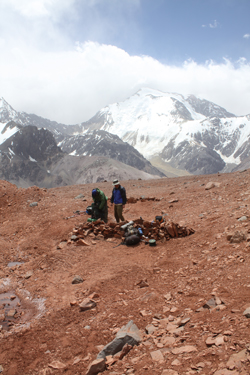 About half way to La Vitrola, the wind strengthened and we cut a short distance off to the right to drop over a short bank to drink and have a snack out of the wind. We took in the view . . . the Valle Colorado below us, Mercedario in the distance, La Mesa to our front and to our left, the upper reaches of La Ramada. As seemed to always be the case, the summit of Ramada never seemed more than a few thousand feet above us, when in reality we still had over 6000 feet of vertical climb between us and the top. Soon enough we again hefted the packs and walked the final 20 minutes to the Vitrola Camp. Again, it seemed we might be without water, necessitating a climb to the next higher camp, Torres Rosadas, but we lucked out once G and Manuel walked over a shallow rise and found water pockets tucked up against the slope behind the camp. About half way to La Vitrola, the wind strengthened and we cut a short distance off to the right to drop over a short bank to drink and have a snack out of the wind. We took in the view . . . the Valle Colorado below us, Mercedario in the distance, La Mesa to our front and to our left, the upper reaches of La Ramada. As seemed to always be the case, the summit of Ramada never seemed more than a few thousand feet above us, when in reality we still had over 6000 feet of vertical climb between us and the top. Soon enough we again hefted the packs and walked the final 20 minutes to the Vitrola Camp. Again, it seemed we might be without water, necessitating a climb to the next higher camp, Torres Rosadas, but we lucked out once G and Manuel walked over a shallow rise and found water pockets tucked up against the slope behind the camp.
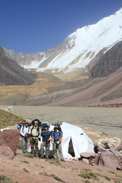
 We dropped the packs and scoped out the water . . . clear but with salty looking precipitates around the edges here and there. I think we all had momentary visions of a traverse of the Overland trail and finding a sign leaning up against a sun bleached ox skull with the words "badwater" etched into a salt encrusted board. Screw it, we didn't see any guanaco bones, hadn't heard any horror stories from Anibal and this spot had been camped before. We had made it to our first camp on the way up la Ramada. We dropped the packs and scoped out the water . . . clear but with salty looking precipitates around the edges here and there. I think we all had momentary visions of a traverse of the Overland trail and finding a sign leaning up against a sun bleached ox skull with the words "badwater" etched into a salt encrusted board. Screw it, we didn't see any guanaco bones, hadn't heard any horror stories from Anibal and this spot had been camped before. We had made it to our first camp on the way up la Ramada.
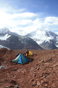
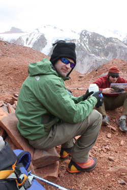 We first set up the Megamid to serve as a cook and social tent. G and I are huge fans of the Black Diamond Megamid and brought ours along as we did not bring big mountaineering tents that would have provided room to cook in a vestibule. We wanted instead to have a cook tent, like we did in Peru and Bolivia, where we could cook, eat, and sit around before going to sleep in the all too tight Bibleresque shelters. We got the Mid up and Manuel went about heating water for a round of mate and dinner a bit later. In the meantime, we set up the two sleeping tents, splitting a single tent pad that we widened out just a bit. Once the tents were set up, we went about acclimatizing . . . wandering around the vicinity, reading, drinking mate, peeing, eating dinner and then calling it a night after the sun went down and it started getting a bit on the cold side. We first set up the Megamid to serve as a cook and social tent. G and I are huge fans of the Black Diamond Megamid and brought ours along as we did not bring big mountaineering tents that would have provided room to cook in a vestibule. We wanted instead to have a cook tent, like we did in Peru and Bolivia, where we could cook, eat, and sit around before going to sleep in the all too tight Bibleresque shelters. We got the Mid up and Manuel went about heating water for a round of mate and dinner a bit later. In the meantime, we set up the two sleeping tents, splitting a single tent pad that we widened out just a bit. Once the tents were set up, we went about acclimatizing . . . wandering around the vicinity, reading, drinking mate, peeing, eating dinner and then calling it a night after the sun went down and it started getting a bit on the cold side.
We were now camped at an elevation of 15,006 feet, we had no major blunders so far, no injuries, and everyone was still healthy. We discussed what the next move would be and decided to remain the next day at the Vitrola camp so we could further acclimatize in preparation for our climb to either the Torres Rosadas or higher Alto Camp.
|
