Mount Democrat
January 15, 2012 - Southwest Ridge from Kite Lake
Two years ago, on a climb of adjacent Mt. Buckskin, G and I scoped out the jagged ridge that connects Buckskin to Mount Democrat. The ridge had lots of ups and downs, translating to it looked like a no less than Class 3 adventure. We'd talked of doing it the following summer but never got around to it. The word was out that due to the very dry winter to date, one could drive all the way to the summer trailhead at Kite Lake. Though it was January, if we could drive that close, why not take a chance and try a winter climb of the route?
 We left Cheyenne the evening before and, after stopping for dinner en route, arrived at the motel in Fairplay where I had reserved a room. The choice was one of getting up very early and driving 3 hours to the trailhead on Sunday morning or just going down the night before, sleeping in a bit later, and then getting to the trailhead having gotten a decent night's sleep the night before. We set the alarms for 5:15 and were out the door and headed for the trailhead by 6:15 a.m. We arrived a bit before 7, having stopped for some coffee and eats and watched the wind, which we knew was part of the forecast, bend a fiberglass campsite number stake well out of the vertical. The temp was about 27 degrees, not bad, but the wind was going to make for a cold start. We left Cheyenne the evening before and, after stopping for dinner en route, arrived at the motel in Fairplay where I had reserved a room. The choice was one of getting up very early and driving 3 hours to the trailhead on Sunday morning or just going down the night before, sleeping in a bit later, and then getting to the trailhead having gotten a decent night's sleep the night before. We set the alarms for 5:15 and were out the door and headed for the trailhead by 6:15 a.m. We arrived a bit before 7, having stopped for some coffee and eats and watched the wind, which we knew was part of the forecast, bend a fiberglass campsite number stake well out of the vertical. The temp was about 27 degrees, not bad, but the wind was going to make for a cold start.
 We waited for the sun to come up and set a "we ARE going to get out of the warm truck at 7:28" goal so we could heft the packs, make any last minute adjustments and be on the trail at 7:30. Strictly a psychological means of getting going on a bit of a blustery cold morning. The keys went into the usual hiding spot and we were walking at the appointed moment in time. I took the lead as we followed the summer trail that traces up the slope, setting a course for Lake Emma. We figured to cut up toward the lake and then scope out where We waited for the sun to come up and set a "we ARE going to get out of the warm truck at 7:28" goal so we could heft the packs, make any last minute adjustments and be on the trail at 7:30. Strictly a psychological means of getting going on a bit of a blustery cold morning. The keys went into the usual hiding spot and we were walking at the appointed moment in time. I took the lead as we followed the summer trail that traces up the slope, setting a course for Lake Emma. We figured to cut up toward the lake and then scope out where 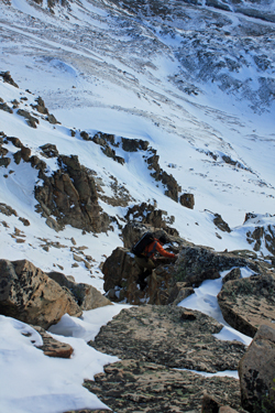 on the ridge we would start our traverse. Our hardcore side said to start at the low point, the saddle between Buckskin and Democrat, but we were also gauging the snow as we went along as to avalanche potential. on the ridge we would start our traverse. Our hardcore side said to start at the low point, the saddle between Buckskin and Democrat, but we were also gauging the snow as we went along as to avalanche potential.
We knew very little of the ridge itself, having not been able to find a trip report so we were trying to gauge
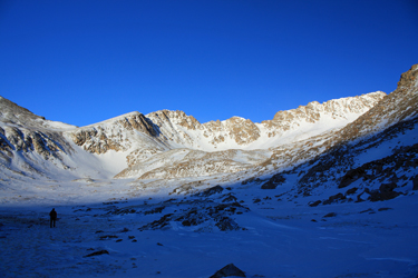
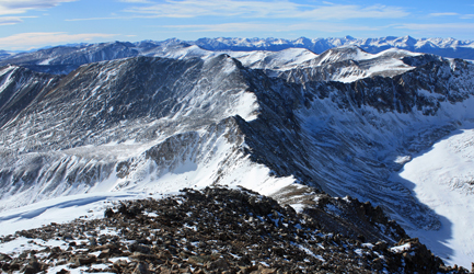
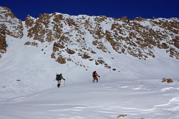
the class of climbing that we would encounter and the degree to which the wind would encumber our progress. We circled upward toward Lake Emma and after gaining the first bench, crossing lots of wind hammered snow and seeing the entirety of the ridge, we opted for the least loaded couloir as the best option. Even though this would put us on the ridge about 2/3 of the way to Democrat, we would avoid what we knew to be snow 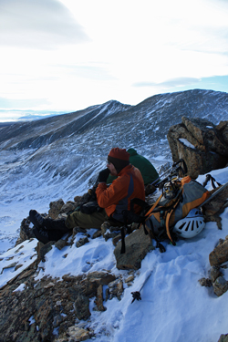 loaded slabs filling the other entry points. Additionally, the wind gusts were swirling snow about the ridge line, leading no doubt as to where the wind chill would strike our hands and feet. loaded slabs filling the other entry points. Additionally, the wind gusts were swirling snow about the ridge line, leading no doubt as to where the wind chill would strike our hands and feet.
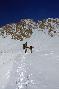
We climbed the next bench, kicking steps and avoiding areas where powder covered blue ice to gain the high ground above Lake Emma. The lake was clearly well frozen as were some of our hands and toes at this point, but we circled around the southwest flank of the lake and climbed a bit of a serpentine course 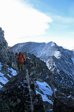 toward the base of the couloir we would use to access the ridge. After crossing one dip, G led up to the base of the shallow gully and began to fight just about every type of snow condition one could choose from. Thigh deep sugar, wind hammered crust, and everything in between. We swapped off leading and breaking the trail that ranged from snow wallows to dainty foot placements calculated to not break the upper most layer and offering purchase for another hopefully equal non sinking step. toward the base of the couloir we would use to access the ridge. After crossing one dip, G led up to the base of the shallow gully and began to fight just about every type of snow condition one could choose from. Thigh deep sugar, wind hammered crust, and everything in between. We swapped off leading and breaking the trail that ranged from snow wallows to dainty foot placements calculated to not break the upper most layer and offering purchase for another hopefully equal non sinking step.
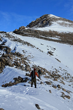 The challenging snow continued up through the couloir for its entire length so when just about 50 vertical feet from the ridge line, I cut left up an icy slot and gained the ridge through about 30 feet of class 3/4 climbing. Bob took the right hand option and climbed rotten snow to the the ridge. G followed my course and after traversing perhaps 50 yards of additional ridge, we gathered in wind shadow for a break before moving onward along the ridge toward the summit. The route to the summit looked clear though we could not see the summit from our stopping point. We figured to cross a gap in the ridge and then expected rolling ground to the top. However after crossing and climbing back to the ridge, we saw that we would have to take to the opposite side and negotiate some class 2+ ground for another 100 yards before the summit was just a gentle ridge hike away. The challenging snow continued up through the couloir for its entire length so when just about 50 vertical feet from the ridge line, I cut left up an icy slot and gained the ridge through about 30 feet of class 3/4 climbing. Bob took the right hand option and climbed rotten snow to the the ridge. G followed my course and after traversing perhaps 50 yards of additional ridge, we gathered in wind shadow for a break before moving onward along the ridge toward the summit. The route to the summit looked clear though we could not see the summit from our stopping point. We figured to cross a gap in the ridge and then expected rolling ground to the top. However after crossing and climbing back to the ridge, we saw that we would have to take to the opposite side and negotiate some class 2+ ground for another 100 yards before the summit was just a gentle ridge hike away.
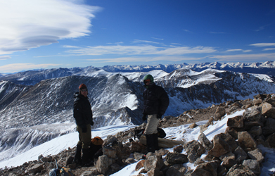 After leaving the ridge behind we climbed the more gentle SW shoulder to the summit where we took in the view of the Sawatch, the Elks, and the Front Range. The Sawatch seemed quite a bit more snowy than the Mosquitos but we knew that range too was a bit shy as to snow this year. The wind that had harried our ascent died to nothing and we ate lunch on the summit . . . about 20 minutes with nary a shiver. A couple coming up the main route came and went with their mooching hounds before the clouds began to cast a shadow over the summit, leading to our departure. The descent was on the tourist track first down to the relative flat at the cusp of the shoulder dropping down to the Democrat/Cameron saddle. The route was summer obvious and well packed by recent traffic. After leaving the ridge behind we climbed the more gentle SW shoulder to the summit where we took in the view of the Sawatch, the Elks, and the Front Range. The Sawatch seemed quite a bit more snowy than the Mosquitos but we knew that range too was a bit shy as to snow this year. The wind that had harried our ascent died to nothing and we ate lunch on the summit . . . about 20 minutes with nary a shiver. A couple coming up the main route came and went with their mooching hounds before the clouds began to cast a shadow over the summit, leading to our departure. The descent was on the tourist track first down to the relative flat at the cusp of the shoulder dropping down to the Democrat/Cameron saddle. The route was summer obvious and well packed by recent traffic.
 We easily made the descent to the shoulder and there stopped to shed our down as the rest of the route was in sun and the air remained still.The rest of the route was just the old trail leading back down through the upper end of the gulch above Kite Lake to the car. The old mine buildings that were standing when I climbed this route in 1998 now lay as flattened piles of lumber, having fallen victim to time and winters past. After a climb of just a bit over five hours, we arrived back at the truck and soon were headed down the road, Denver bound in search of some post climb lomo saltado. We easily made the descent to the shoulder and there stopped to shed our down as the rest of the route was in sun and the air remained still.The rest of the route was just the old trail leading back down through the upper end of the gulch above Kite Lake to the car. The old mine buildings that were standing when I climbed this route in 1998 now lay as flattened piles of lumber, having fallen victim to time and winters past. After a climb of just a bit over five hours, we arrived back at the truck and soon were headed down the road, Denver bound in search of some post climb lomo saltado.
|
