-
Mt. Bierstadt Group Summit - Front Range, Colorado
-
A rest before the summit push on Dallas Peak - San Juan Range, Colorado
-
Broken Ankle + 6 Miles = Tired
-
The classic San Juan approach - San Juan Range, Colorado
-
Overlooking Noname Basin from Twin Thumbs Pass - San Juan Range, Colorado
-
Upper Noname Basin - San Juan Range, Colorado
-
Nearing Noname Cabin - San Juan Range, Colorado
-
Twin Thumbs Twins - San Juan Range, Colorado
-
Nearing the summit of Pt. 13,736 - Sawatch Range, Colorado
-
Blustery day on Iowa Peak - Sawatch Range, Colorado
-
Morning snow at 15k, Cerro Ramada - Cordillera Ramada
-
Artesonraju from the summit of Nevado Pisco - Cordillera Blanca, Peru
-
February crowds on Gray's Peak - Front Range, Colorado
-
Kicking steps on Cerro Lliani - Cordillera Vilcanota, Peru
-
Final traverse to the summit of Wheeler Mountain - Ten Mile Range, Colorado
-
The long walk to Pachanta - Cordillera Vilcanota, Peru
- banner31
Afternoon at 17k on Cerro Ramada - Cordillera Ramada, Argentina
- banner22
The final ridge on Iowa Peak - Sawatch Range, Colorado
-
Summer summit on Longs Peak - Front Range, Colorado
-
A rest day at the Pachanta Hot Springs - Cordillera Vilcanota, Peru
-
Mind over matter on Mt. Parnassas - Front Range, Colorado
-
Rest stop on Cerro Lliani - Cordillera Vilcanota, Peru
- banner30
Post nap surprise on Cerro Ramada - Cordiller Ramada, Argentina
-
Summit on Cerro Lliani - Cordillera Vilcanota, Peru
- banner23
Ridge walking on Grizzly Peak - Sawatch Range, Colorado
-
Enroute the summit via the West Ridge on Pacific Peak - Ten Mile Range, Colorado
-
Mule train bound for Chilca - Cordillera Vilcanota, Peru
-
Taking in the view from Fletcher Peak - Ten Mile Range, Colorado
-
Hiking on Silverheels - Mosquito Range, Colorado
-
Traversing! Gladstone Peak - San Juan Range, Colorado
- banner24
The best of times at Willow Lake - Sangre de Christo Range, Colorado
- banner29
High Altitude Cerebral Edema? - Cordillera Ramada, Argentina
-
Bound for Chilca - Vilcanota Range, Peru
-
Going alpine light, Holy Cross Ridge - Sawatch Range, Colorado
-
Cumbre! Campa I - Cordillera Vilcanota, Peru
-
Roadside lunch with the best of company - Cordillera Vilcanota, Peru
- banner25
Long ridge walk to the summit of California Peak - Sangre de Christo Range, Colorado
- banner28
Crossing el Rio Colorado . . . in the afternoon - Cordillera Ramada, Argentina
- banner37
Dealing with Fall snows high on Casco Peak - Sawatch Range, Colorado
-
Moonrise over Mercedario - Cordillera Ramada, Argentina
-
Still climbing at 20,900 on Cerro Ramada - Cordiller Ramada, Argentina
-
Talus on Halo Ridge, Mt. of the Holy Cross - Sawatch Range, Colorado
- banner26
Deteriorating conditions on Mt. Arkansas - Ten Mile Range, Colorado
- banner27
After the climb - Cordillera Ramada, Argentina
- banner38
Taking in the view from the summit of Crystal Peak - Tenmile Range, Colorado
-
Topping out on Mt. Arkansas' North Couloir - Mosquito Range, Colorado
-
Glissade on Mt. Arkansas - Mosquito Range, Colorado
-
Hard snow morning on Teakettle Mountain - San Juan Range, Colorado
-
Spring snow announces the start of the climb on Dallas Peak - San Juan Range, Colorado
-
Crossing the Eolus Catwalk - San Juan Range, Colorado

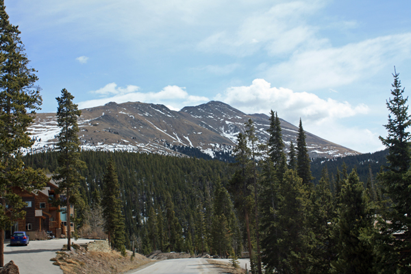
 I left Cheyenne at 4:15 a.m. and a few hours later I was parked at the end of the USFS road that leads to the Iowa Mill and various mines on the northern flank of the peak. The temp coming through town was 22 degrees but it was definitely getting warm fast. I packed light, cutting the layers down to summer levels and electing to go with hiking boots in lieu of the plastics. Being from Wyoming. I am so accustomed to cold that taking shorts or not taking a heavy and a light long underwear top along on a climb is literally something I must remind myself to do or not do. I hefted the pack and was on my way at a bit before 8 a.m.
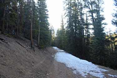
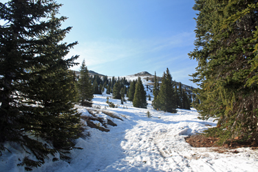 The road went for about a mile or so up through the trees, not climbing fast but gently ascending to the Iowa Mill, located at right about tree line. There were patches of snow here and there on the road but about 1/4 mile shy of the mill, it was snow time. The night before had been cold enough to give a good freeze so I tramped atop the frozen drifts, passing the mill and electing to stay on the road for another 100 yards or so. The mill is the terminus of an aerial tramway that runs to the Magnolia Mine up on the northern ridge of the mountain and as such, the cable course offers a "direct to ridge" track. I opted to skip the switch backing road course, adopt a cable left bearing and went right onto the snow covered slope that was hard sun cupped snow with nary a posthole to be suffered. I steadily climbed, neither fast nor slow but gained the ridge line proper after an hour or so.
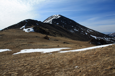 The ridge marked the end of the easy snow climbing, now it would be dirt and rock for the rest of the climb. The previous mining activity resulted in a road and later a two track to high on the mountain so I just I followed the course of the jeep path up over the first false summit. From there I kicked a set of steps up 50 vertical feet of the most wonderful neve this side of the Andes and then hoofed my way along the ambling ridge as it rose and fell for a few humps before coming to the last 600 feet of vertical. This stretch is a nice class 2 talus ridge walk with braided trails in the steep sections and the need to watch the footing here and there. I took the steep sections on directly to avoid curving paths around them figuring that I did not need to lose any elevation for the sake of following Cottoneer herd paths.
 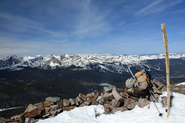 No portion of the trail exceeded class 2 and after a total climb of three hours I was on the summit. The snow conditions in the surrounding ranges were clearly sparse and the climb that I completed required no axe, no crampons . . . just a hike up the 3000 feet of vertical from the parking spot to the summit. I took a few photos and made my way back down to the truck, the whole climb being over and done with in a bit over four hours. This summit also turned out to be summit #100 of Colorado's 200 highest peaks and gave me some reassurance that my weakened solo climbing mojo the past weekend was now fully recovered.