Longs Peak
August 30, 2009 - Northwest Couloir/North Face
(photos from Keyhole to Summit - photos of North Face descent route may be found on pages describing earlier North Face/Cables Route summer and winter climbs)
Friends don't let friends drive drunk nor should they let them climb the Keyhole route under non technical conditions. Bob had not climbed Longs and was itching to climb so I suggested Longs by a different route. I'd read of the Northwest Couloir in a route guide as well as on multiple trip reports on 14ers.com, hence the trap was baited and set. I suggested a midnight departure from Cheyenne to hit the parking lot at 2 p.m . . . just in time to ensure a parking spot on what I figured would be the last "summer" weekend.
 The plan was good to go but then Bob decides that midnight is too early. At the age of 36, he is a bit young to be showing the first sign of old age, which is not wear on a specific body part but instead the loss of the alpine start (I credit John Bicknell, Colorado Mountain School, for this observation). We did for Bob what best for him, gave him an extra hour of sleep in the form of an instruction to be at my place by one o'clock or endure the thought of a day on the mountain . . . missed. Now for the plus side, he was in front of my place a few minutes before one and without a doubt, psyched and ready to go. The plan was good to go but then Bob decides that midnight is too early. At the age of 36, he is a bit young to be showing the first sign of old age, which is not wear on a specific body part but instead the loss of the alpine start (I credit John Bicknell, Colorado Mountain School, for this observation). We did for Bob what best for him, gave him an extra hour of sleep in the form of an instruction to be at my place by one o'clock or endure the thought of a day on the mountain . . . missed. Now for the plus side, he was in front of my place a few minutes before one and without a doubt, psyched and ready to go.
 Bob's number was up as to driving so we were off to Estes in his Honda Accord and just two hours later we pulled into the trail head parking lot to get one of the last spaces available. We'd debated whether the "season" did in fact go past the start of school and I assure you it does. There were groups here and there getting ready and we joined them in preparing our gear for the day. I took the climbing rack, Bob the rope, and G drew the pump and other miscellaneous group gear. We signed the trail register at 3:30 and headed up a trail that, for G and myself, was more than familiar. We knew we had a six mile approach and for the first time in a long time, the trail was not covered with snow. We planned to take it slow and steady, figuring we'd get passed by the Cottoneers, who we would in turn pass as their early trail sprints were drawn to a conclusion by the combination of altitude and distance. Bob's number was up as to driving so we were off to Estes in his Honda Accord and just two hours later we pulled into the trail head parking lot to get one of the last spaces available. We'd debated whether the "season" did in fact go past the start of school and I assure you it does. There were groups here and there getting ready and we joined them in preparing our gear for the day. I took the climbing rack, Bob the rope, and G drew the pump and other miscellaneous group gear. We signed the trail register at 3:30 and headed up a trail that, for G and myself, was more than familiar. We knew we had a six mile approach and for the first time in a long time, the trail was not covered with snow. We planned to take it slow and steady, figuring we'd get passed by the Cottoneers, who we would in turn pass as their early trail sprints were drawn to a conclusion by the combination of altitude and distance.
 We were passed by a couple of groups of sprinters and then found our spot in the long line of twinkling headlamps that from Granite Pass look like glowing beads strung along the sinuous curve of the trail as it climbs to the Boulderfield. We made our first stop at Granite Pass to shoot a Goo and take a sip of water before going on to the Boulderfield to fill our water bottles for the climb proper. We scoped out the North Face and saw but one group approaching that route, the remainder had their hearts and minds set on the Keyhole. We discussed climbing the North Face but I was pretty psyched for a different ascent route and wanted to give the Northwest Couloir a go. We agreed that would be the plan and reserved the North Face for the descent route. We were passed by a couple of groups of sprinters and then found our spot in the long line of twinkling headlamps that from Granite Pass look like glowing beads strung along the sinuous curve of the trail as it climbs to the Boulderfield. We made our first stop at Granite Pass to shoot a Goo and take a sip of water before going on to the Boulderfield to fill our water bottles for the climb proper. We scoped out the North Face and saw but one group approaching that route, the remainder had their hearts and minds set on the Keyhole. We discussed climbing the North Face but I was pretty psyched for a different ascent route and wanted to give the Northwest Couloir a go. We agreed that would be the plan and reserved the North Face for the descent route.
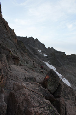
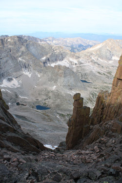
 We made the Keyhole and played through a number of groups making the decision to continue or not, based upon their first impressions of the Ledges section of that route. We shot another Goo, took a sip and moved on along the Ledges until likely about 2/3 of the distance to the entry to the Trough Couloir. After going about 2/3 of the way, sure enough, there was a couloir and I noted the four pillars and "horseman" or "knight" that I had read of as being indicative of the route. I advised the group that we were at the start of the Couloir and off Bob went. Now we don't climb with any organization, no set leader, no set sweep, but Bob just took off heading upward , leaving no doubt who was the lead on this route. We got up about 50 feet and advised the Cottoneers debating whether to follow us, that we were not on route and that they should continue on to the Trough. On they went and upward we went. We made the Keyhole and played through a number of groups making the decision to continue or not, based upon their first impressions of the Ledges section of that route. We shot another Goo, took a sip and moved on along the Ledges until likely about 2/3 of the distance to the entry to the Trough Couloir. After going about 2/3 of the way, sure enough, there was a couloir and I noted the four pillars and "horseman" or "knight" that I had read of as being indicative of the route. I advised the group that we were at the start of the Couloir and off Bob went. Now we don't climb with any organization, no set leader, no set sweep, but Bob just took off heading upward , leaving no doubt who was the lead on this route. We got up about 50 feet and advised the Cottoneers debating whether to follow us, that we were not on route and that they should continue on to the Trough. On they went and upward we went.
 I must interject a cautionary note at this point and that is that we really took our time going up this route to ensure that we did not knock any rock loose in the process. The route does not see a lot of traffic and there is a great deal of loose laying on the ledges that if dislodged will head straight down to intercept some Cottoneer traversing the base of the couloir. This is some serious "be careful" country and for this reason we planned not to rope up unless we really needed to as an extra effort to avoid any rock fall. Anyone climbing this route would be well advised to keep the group small, move in a deliberate manner and think rock. I must interject a cautionary note at this point and that is that we really took our time going up this route to ensure that we did not knock any rock loose in the process. The route does not see a lot of traffic and there is a great deal of loose laying on the ledges that if dislodged will head straight down to intercept some Cottoneer traversing the base of the couloir. This is some serious "be careful" country and for this reason we planned not to rope up unless we really needed to as an extra effort to avoid any rock fall. Anyone climbing this route would be well advised to keep the group small, move in a deliberate manner and think rock.
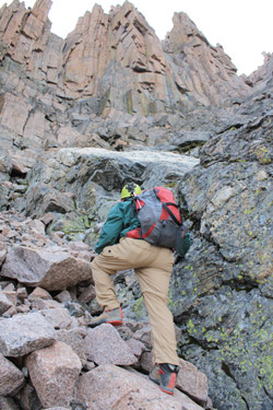
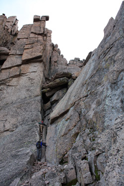
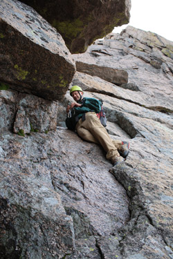
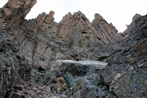
 The route starts out as class 2+ climbing and as you ascend it passes through the class 3 grade to settle in comfortably at class 4. However, any substantive deviation from the course of least resistance will land you in solid class 5+ territory, if in fact, some of what we treated as class 4 is not really 5.low turf. This was clearly helmet country and there was no lack of high angle climbing, but with good solid hand and footholds. We made steady progress upward, staying more to the right side than the left, even though one guide cautioned that the right was the tougher course to follow. We climbed perhaps 1/3 of the way and caught sight of the jumble of rock fall, actually large boulder fall, that has wedged itself in a fissure on the left side of the couloir and formed a "cave" of sorts that one climbs up and through to surpass the obstacle. Bob, still in the lead, took the fissure below the jumble head on and soon stood a few feet below the rock forming the base of the cave. The route starts out as class 2+ climbing and as you ascend it passes through the class 3 grade to settle in comfortably at class 4. However, any substantive deviation from the course of least resistance will land you in solid class 5+ territory, if in fact, some of what we treated as class 4 is not really 5.low turf. This was clearly helmet country and there was no lack of high angle climbing, but with good solid hand and footholds. We made steady progress upward, staying more to the right side than the left, even though one guide cautioned that the right was the tougher course to follow. We climbed perhaps 1/3 of the way and caught sight of the jumble of rock fall, actually large boulder fall, that has wedged itself in a fissure on the left side of the couloir and formed a "cave" of sorts that one climbs up and through to surpass the obstacle. Bob, still in the lead, took the fissure below the jumble head on and soon stood a few feet below the rock forming the base of the cave.
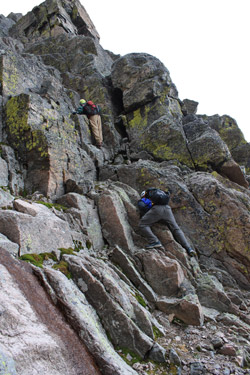
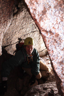
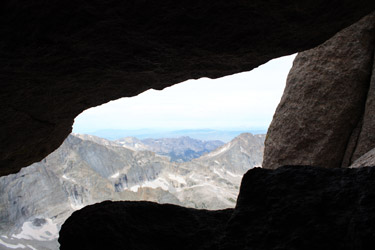 The next move, I'm going to up the ante to class 5.low, required him to go out onto the adjoining face a few feet, using a four inch wide ledge to approach the short climb to the opening. There is an old piton here to which Bob attached a sling to provide a handhold and bit of safety in the event of a slip. The move is exposed and, though we did not rope up to make it, any party would be well advised to do so if there is any doubt as to the exposure which will most certainly compensate a falling climber with a plaster cast for his or her failed effort. Bob made the move, followed by G, who being long of leg, was able to use the piton as a foothold and move smartly to the opening. I followed with a repeat of G's move and squeezed past Bob into the fissure. The passage through the jumble is obvious and to an experienced caver will present neither hesitation nor The next move, I'm going to up the ante to class 5.low, required him to go out onto the adjoining face a few feet, using a four inch wide ledge to approach the short climb to the opening. There is an old piton here to which Bob attached a sling to provide a handhold and bit of safety in the event of a slip. The move is exposed and, though we did not rope up to make it, any party would be well advised to do so if there is any doubt as to the exposure which will most certainly compensate a falling climber with a plaster cast for his or her failed effort. Bob made the move, followed by G, who being long of leg, was able to use the piton as a foothold and move smartly to the opening. I followed with a repeat of G's move and squeezed past Bob into the fissure. The passage through the jumble is obvious and to an experienced caver will present neither hesitation nor 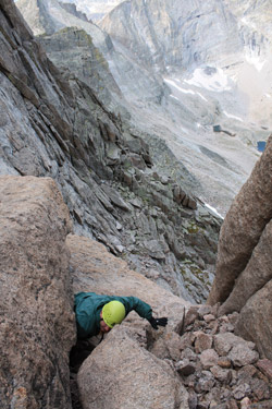 difficulty. You won't get through with your pack on, as you must lie on your back and rotate through the opening that has perhaps 14 to 16 inches of vertical clearance. G moved through and then I followed. difficulty. You won't get through with your pack on, as you must lie on your back and rotate through the opening that has perhaps 14 to 16 inches of vertical clearance. G moved through and then I followed.
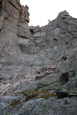
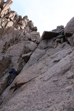 Bob passed the packs to me and I passed them onward to G, before Bob too came through the opening an continued our route toward the ridge proper. The climb above the cave constitutes perhaps one third of the vertical but offers more crack and fissure climbs, perhaps for another 100 feet vertical before one cuts to the right to ascend the last 75 feet of hand and foot climbing to the ridge. Once on the ridge, the route to the summit is clear and given the time of year, we saw multiple Cottoneers silhouetted against the clear morning sky. To say that the ridge is solid would be a gross understatement. We took a sip and shot a Goo before taking to the sloping rubble free granite ramp that led, with a crack here and there, straight to the summit. To the right is the sloping west face of the mountain, falling to the depths of the upper most reaches of Glacier Gorge and to the left, the rock slopes away down the angled North Face and Cables Route. Bob passed the packs to me and I passed them onward to G, before Bob too came through the opening an continued our route toward the ridge proper. The climb above the cave constitutes perhaps one third of the vertical but offers more crack and fissure climbs, perhaps for another 100 feet vertical before one cuts to the right to ascend the last 75 feet of hand and foot climbing to the ridge. Once on the ridge, the route to the summit is clear and given the time of year, we saw multiple Cottoneers silhouetted against the clear morning sky. To say that the ridge is solid would be a gross understatement. We took a sip and shot a Goo before taking to the sloping rubble free granite ramp that led, with a crack here and there, straight to the summit. To the right is the sloping west face of the mountain, falling to the depths of the upper most reaches of Glacier Gorge and to the left, the rock slopes away down the angled North Face and Cables Route.
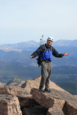
 We reached the summit at 10:30, after a climb of 7 hours. I figure we could have scored the Keyhole in an hour less but again, we knew that Bob would be subjected to Cotton shock at the summit so we selected the off the beaten path route. My count for the summit was 54 climbers upon our arrival, dead on as to my parking lot estimate that there would be 40 to 60 on the summit when we arrived. We doffed our helmets and joined the pack in eating a snack before gearing up for the trip down the North Face. We wandered around to look down the Diamond, look east to Storm Peak (one cold january climb of many winters ago), and peered off toward Pagoda wondering how in the heck we climbed it one winter day wearing ski boots so that we would not have to snowshoe out Glacier Gorge. We saw enough and returned to the packs to break out the Alpine Bods and get the gear in order for the two half rope rappels down the North Face. We reached the summit at 10:30, after a climb of 7 hours. I figure we could have scored the Keyhole in an hour less but again, we knew that Bob would be subjected to Cotton shock at the summit so we selected the off the beaten path route. My count for the summit was 54 climbers upon our arrival, dead on as to my parking lot estimate that there would be 40 to 60 on the summit when we arrived. We doffed our helmets and joined the pack in eating a snack before gearing up for the trip down the North Face. We wandered around to look down the Diamond, look east to Storm Peak (one cold january climb of many winters ago), and peered off toward Pagoda wondering how in the heck we climbed it one winter day wearing ski boots so that we would not have to snowshoe out Glacier Gorge. We saw enough and returned to the packs to break out the Alpine Bods and get the gear in order for the two half rope rappels down the North Face.
We easily located the head end of the trail to the North Face descent and crisscrossed our way down the summer track to the lower of the two upper eyebolts that remain from the days of the Cable Route. We rigged the rope for the rappel and 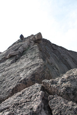 after cross checking each other's gear, I was on my way down the first pitch to the mid point eyebolt. I set a sling for all to snap into on arrival, went off rappel and belayed Bob to the mid point position. The mid point eyebolt is conveniently located at a flat spot on the climb and there is plenty of room for two or three to stand about, using the sling for safety rather than for support. G joined me and we repeated the process using the doubled rope to land all three of us at the base of the North Face, just a few sloping ledges from the break in the ridge connecting Mt. Lady Washington and the North Face, a.k.a. Chasm View. after cross checking each other's gear, I was on my way down the first pitch to the mid point eyebolt. I set a sling for all to snap into on arrival, went off rappel and belayed Bob to the mid point position. The mid point eyebolt is conveniently located at a flat spot on the climb and there is plenty of room for two or three to stand about, using the sling for safety rather than for support. G joined me and we repeated the process using the doubled rope to land all three of us at the base of the North Face, just a few sloping ledges from the break in the ridge connecting Mt. Lady Washington and the North Face, a.k.a. Chasm View.
 We stowed the rope and descended to peer from Chasm View at two climbers finishing an ascent of the Diamond. The harnesses and descent gear next went into the packs with the helmets and we were off for the car. Our next stop was the point on the trail through the Boulderfield where the small stream allowed us to pump water and from there we took only a short break just below the Abyss Lake cut off before reaching the car. We stowed the rope and descended to peer from Chasm View at two climbers finishing an ascent of the Diamond. The harnesses and descent gear next went into the packs with the helmets and we were off for the car. Our next stop was the point on the trail through the Boulderfield where the small stream allowed us to pump water and from there we took only a short break just below the Abyss Lake cut off before reaching the car.
Bob scored another 14'er and G and I got to summit Longs via a route other than the standard Keyhole Route during the summer season. The total time, car to car, was just about 12 hours even, not the greatest time but we did the climb pretty much without stops other than about 1/2 hour on the summit. Our Northwest Couloir ascent was traffic free and we passed but three going up as we descended the North Face, about one half way from the top of the climb to the summit proper. The Northwest Couloir is a wonderful route but any group giving it thought should not underestimate the matter of rock fall onto the Keyhole trail below and most assuredly must take every effort to avoid dislodging any loose onto the lower course.
|
