Wheeler Mountain
March 27, 2011 - via Wheeler Lake (wintery attempt)
May 21, 2011 - via Wheeler Lake (wintery attempt)
July 23, 2011 - via Wheeler Lake (a summit at last!)
March 27, 2011 Attempt . . .
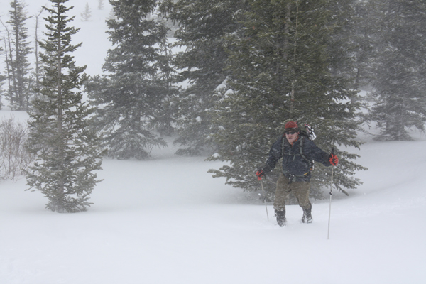
G and I needed to get out and we chose Wheeler Peak as it was a Mosquito Range Peak that neither of us had done before and offered both a snow climb and ridge that would be at least semi technical. We also wanted to get out on the AT skis and figured that Wheeler would offer an easy skin in and likely a decent ski out through the long valley floor approach. The weather forecast was borderline but when faced with giving it a try or sitting in Cheyenne, we were on our way to Colorado without too much additional thought.
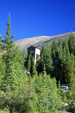
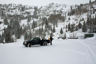 We parked at the end of the road along the Montgomery Reservoir, stopping just shy of the Hoosier water diversion tunnel and gate that closed the road to further traffic. The skis went onto the packs as there was more road that curved around the end of the reservoir before cutting up into the snows at the Magnolia Mill. We hoofed the road portion to the spur that cuts off to follow the reservoir and then put on the skis to start skinning up valley. The weather was lousy, snow and wind, but we figured if we got into the valley proper, we'd get some break from the wind and if nothing else get a good dose of physical conditioning. We parked at the end of the road along the Montgomery Reservoir, stopping just shy of the Hoosier water diversion tunnel and gate that closed the road to further traffic. The skis went onto the packs as there was more road that curved around the end of the reservoir before cutting up into the snows at the Magnolia Mill. We hoofed the road portion to the spur that cuts off to follow the reservoir and then put on the skis to start skinning up valley. The weather was lousy, snow and wind, but we figured if we got into the valley proper, we'd get some break from the wind and if nothing else get a good dose of physical conditioning.
We skinned past the mill, going up the creek gully and then located a portion of the 4WD road and followed it for about a mile up into the valley. The weather was not improving, the snow was deep and there was not enough visibility to see an appreciable distance up the valley. We knew from the start this would not be a summit day so after a mile, we turned and headed to Denver to score some lomo saltado at the Los Cabos II Peruvian Restaurant.
May 21, 2011 Attempt . . .
 Our trip to Peru was only three weeks away so G, Malbec and I were looking to get out and train a bit in preparation for the upcoming trip. I'd gotten out two weeks before but neither G nor bob had been out in a month. Clearly we were all itching to get out . . . but once again winter had a vote as to our plan. Our trip to Peru was only three weeks away so G, Malbec and I were looking to get out and train a bit in preparation for the upcoming trip. I'd gotten out two weeks before but neither G nor bob had been out in a month. Clearly we were all itching to get out . . . but once again winter had a vote as to our plan.
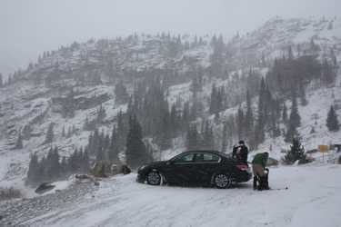
This year's winter simply would not let go of the mountains; the snowpack in many areas was rated at 200% of normal and . . . the melt was just beginning. The forecast called for warm temps and a 30% chance of snow squalls. We arrived at the parking area to find 26 degrees and lots of blowing snow. We had to get out so, after some banter, we geared up and headed up the road toward the Mill with the snowshoes ready 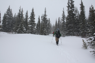 to go. The route had wet spots from the prior warm days and the creek was running but there was plenty of snow, pretty much as much as G and I had found fully two months before. We passed the Mill by about a quarter mile and again had the summit/no summit pow wow as it was obvious that we were experiencing more than a squall as our tracks were filling in quickly behind us. to go. The route had wet spots from the prior warm days and the creek was running but there was plenty of snow, pretty much as much as G and I had found fully two months before. We passed the Mill by about a quarter mile and again had the summit/no summit pow wow as it was obvious that we were experiencing more than a squall as our tracks were filling in quickly behind us.
Given that there would be no summit, we changed the game plan to a P.T. trip. We agreed to go twenty minutes further but at a fast cardio pace, nobody using the tracks of the person in front of them and all cutting left and right to climb the various hillocks and rolls throughout the course up the valley. We all got a 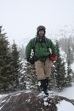 great workout and after 10, then 20, then 30, minutes, we shifted the plan to return but with a twist. The return would once again be a serpentine affair but we would seek to ascend or descend as many short steep steps as possible. As this glaciated valley abounds with rounded rock humps, there is no shortage of little climbs and descents. We consumed another hour working our way out to the parking area. great workout and after 10, then 20, then 30, minutes, we shifted the plan to return but with a twist. The return would once again be a serpentine affair but we would seek to ascend or descend as many short steep steps as possible. As this glaciated valley abounds with rounded rock humps, there is no shortage of little climbs and descents. We consumed another hour working our way out to the parking area.
We did pass a group of three inbound at the reservoir but none of us suggested that they avoid following our tracks. What they must have thought later only they can tell as our initial single file track split into three and undoubtedly seemed to be the wanderings of lunatics lost in a valley in which one would be sorely pressed to lose one's way. We arrived back at the car about 3 hours after departing and knew that since we were Peru bound and since Malbec had never had lomo saltado . . . yes . . . back to Denver for a round of "lomo" at Los Cabo's.
July 23, 2011 - a summit at last . . .
 After two wintery tries, we had a Saturday climbing opportunity and hoped that a summer climb of Wheeler Mountain might yield a summit. We left Cheyenne late, about 4:30 a.m., after an alarm gaff on my part, but were not too worried as the forecast called for minimal chances of afternoon thunderstorms. We arrived at the trail head a bit before 8 a.m. and were headed up the jeep trial by a few minutes after the hour. We'd been up the trail for all of a mile in the past but now it was very different, large rocks and a clear trail instead of a tree cut that in many places we found difficult to follow. No route finding issues this time for sure. After two wintery tries, we had a Saturday climbing opportunity and hoped that a summer climb of Wheeler Mountain might yield a summit. We left Cheyenne late, about 4:30 a.m., after an alarm gaff on my part, but were not too worried as the forecast called for minimal chances of afternoon thunderstorms. We arrived at the trail head a bit before 8 a.m. and were headed up the jeep trial by a few minutes after the hour. We'd been up the trail for all of a mile in the past but now it was very different, large rocks and a clear trail instead of a tree cut that in many places we found difficult to follow. No route finding issues this time for sure.
We walked the jeep trail past the Magnolia Mill and on up through the trees, skirting numerous water filled jeep wallows along the way. After a half mile or so, we broke tree line and followed the road as it wended its way up the valley, not gaining much elevation but 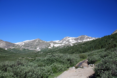 giving us a clear and therefore willow free route toward the head of the valley. We passed the furthest point of our prior winter trips and followed the road to a large snow bank where a trio of jeeps were going about setting a winch cable to negotiate the snowy obstacle. We played through and came to the point there the hanging valley that holds Wheeler Lake joined the main valley. giving us a clear and therefore willow free route toward the head of the valley. We passed the furthest point of our prior winter trips and followed the road to a large snow bank where a trio of jeeps were going about setting a winch cable to negotiate the snowy obstacle. We played through and came to the point there the hanging valley that holds Wheeler Lake joined the main valley.
The road and creek coming down from Wheeler Lake became one at this point so we cut right and climbed upward along the side of the creek, figuring that there was a log or other means of crossing higher up. The melt was not quite in full force but it was also far from over, hence 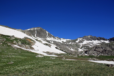 a hop . . . skip and step along the lower combined road/creek would not make for dry feet. We climbed up to where the trail crossed the creek and any stepping stone crossing was clearly under water. However, we scored a crossing to a center island and then tracked down about 75 feet to another crossing point. The apparent crossing did not pan out but we did spot the very tip of a large rock poking above the water and with sure steps, actually long hopeful strides, we both arrived with dry feet on the other side. a hop . . . skip and step along the lower combined road/creek would not make for dry feet. We climbed up to where the trail crossed the creek and any stepping stone crossing was clearly under water. However, we scored a crossing to a center island and then tracked down about 75 feet to another crossing point. The apparent crossing did not pan out but we did spot the very tip of a large rock poking above the water and with sure steps, actually long hopeful strides, we both arrived with dry feet on the other side.
We climbed the hill into the upper basin on a climber's path and intercepted the jeep trail that had continued through the stream course and ascended to the upper basin a bit further 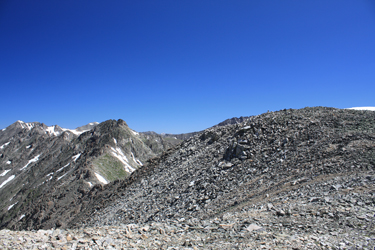 along the valley. The easiest route upward did not appear to be the normal course around the lake but a climb into the next higher basin to the west via a snowfield or two and then a climb up another snowfield to the saddle between McNamee and the mid ridge hump between the two peaks. This course avoided all of the headwalls above Wheeler Lake and after perhaps five to seven hundred feet of vertical, put us on the connecting ridge. To the left was McNamee and to the right was a smooth hump that presaged the more challenging ridge we knew would have to be crossed to summit Wheeler. along the valley. The easiest route upward did not appear to be the normal course around the lake but a climb into the next higher basin to the west via a snowfield or two and then a climb up another snowfield to the saddle between McNamee and the mid ridge hump between the two peaks. This course avoided all of the headwalls above Wheeler Lake and after perhaps five to seven hundred feet of vertical, put us on the connecting ridge. To the left was McNamee and to the right was a smooth hump that presaged the more challenging ridge we knew would have to be crossed to summit Wheeler.
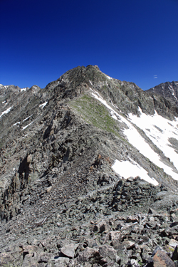 We climbed to the top of the hump and looked out at the connecting ridge that I knew was rumored to be a technical route in winter and a class 3 route in summer and . . . that appeared to be exactly the case. We dropped down to the connecting saddle, crossing a few class 3 sections where the ridge proper was the best route sometimes and where a cut off to one side was the better option in other cases. Our goal was drop to the low grassy connecting point and then pick our way up the ridge to the summit of Wheeler, which we knew was one of a number of spiny points atop the ridge. We climbed to the top of the hump and looked out at the connecting ridge that I knew was rumored to be a technical route in winter and a class 3 route in summer and . . . that appeared to be exactly the case. We dropped down to the connecting saddle, crossing a few class 3 sections where the ridge proper was the best route sometimes and where a cut off to one side was the better option in other cases. Our goal was drop to the low grassy connecting point and then pick our way up the ridge to the summit of Wheeler, which we knew was one of a number of spiny points atop the ridge.
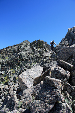 The route stiffened after the saddle and we elected to cover the first half on the ridge crest proper. This route provided more exposure than one generally gets on a Ten Mile range trade route as a fall would clearly have permanent consequences. We ran about 100 yards of spiny ridge before dropping to an intermediate saddle, from which a climber's trail led up and over a few intermediate ribs before ascending to what appeared to be one of three possible summit spines. We took the first obvious course (dirty trail segments) and after another ten minutes of scrambling, walked the ridge to a flat spot complete with summit register. I would venture to guess that the other two high points vary in elevation by no more than a few feet at the most. The route stiffened after the saddle and we elected to cover the first half on the ridge crest proper. This route provided more exposure than one generally gets on a Ten Mile range trade route as a fall would clearly have permanent consequences. We ran about 100 yards of spiny ridge before dropping to an intermediate saddle, from which a climber's trail led up and over a few intermediate ribs before ascending to what appeared to be one of three possible summit spines. We took the first obvious course (dirty trail segments) and after another ten minutes of scrambling, walked the ridge to a flat spot complete with summit register. I would venture to guess that the other two high points vary in elevation by no more than a few feet at the most.
The obligatory offering of a gummy bear was made to Pachamama and after a short break, we descended back along our ascent route to the green saddle point. From there we elected not to re-ascend to the hump but instead to pick our way down the valley to the edge of 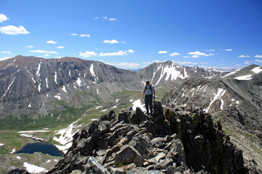 Wheeler lake, which comprises the traditional route on this peak. We descended to a substantive but fairly flat snowfield and used it to traverse left above a cliffy section to the east side of the valley. We scored another descending snowfield and then thought for a second that we'd cliffed out. But, off to the left was a snow filled drop with a path worn on the very edge, our descent route to the ground above the Lake. Wheeler lake, which comprises the traditional route on this peak. We descended to a substantive but fairly flat snowfield and used it to traverse left above a cliffy section to the east side of the valley. We scored another descending snowfield and then thought for a second that we'd cliffed out. But, off to the left was a snow filled drop with a path worn on the very edge, our descent route to the ground above the Lake.
Rather than drop all the way to the Lake, we held perhaps 200 feet of vertical and traversed toward the main valley. Our goal was to avoid a stream re-crossing so we stayed east of the lake's outflow. This course gave an easy descent but as we dropped further down we had to pick our way through low willows at first and finally high willows before intercepting the jeep 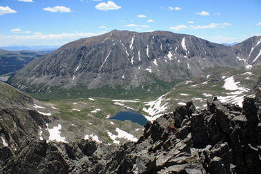 trail. Once on the trail we made easy time to the truck, about 2 miles distant. We made such good time that we played through two jeeps whose descent proved slower than that available to foot traffic by about ten minutes overall. Soon enough we hiked beneath the Mayflower Mill and onto the short stretch of road that leads to the stream flow weir where we had parked the truck along with a half doze other vehicles. The overall climb covered about 3000 vertical feet over nine summer miles and took a bit over 8 hours to complete. trail. Once on the trail we made easy time to the truck, about 2 miles distant. We made such good time that we played through two jeeps whose descent proved slower than that available to foot traffic by about ten minutes overall. Soon enough we hiked beneath the Mayflower Mill and onto the short stretch of road that leads to the stream flow weir where we had parked the truck along with a half doze other vehicles. The overall climb covered about 3000 vertical feet over nine summer miles and took a bit over 8 hours to complete.
|
