Mount Bancroft
July 18, 2008 - Northeast Ridge
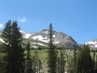 The northeast ridge of Bancroft is a challenging winter route, a long windy ridge of class 4 climbing with an 80 foot drop rappel about one third of the way up. Well, we didn't make it onto the peak in the winter but decided instead to check out the route as an opportunity to do a long scramble on a blue bird summer day. We were not disappointed. The northeast ridge of Bancroft is a challenging winter route, a long windy ridge of class 4 climbing with an 80 foot drop rappel about one third of the way up. Well, we didn't make it onto the peak in the winter but decided instead to check out the route as an opportunity to do a long scramble on a blue bird summer day. We were not disappointed.
My alpine start was waning but after a minute or two of cajoling, G convinced me that we should indeed leave Cheyenne at 4 a.m. to get on the peak by 6:30 or so. I knew it would be a half day climb and that yes, we did have to get an early start to avoid the threat of afternoon storms. We left a few minutes after four and were passing through Idaho Springs right on time, about two hours later. The turn-off to Alice came a few 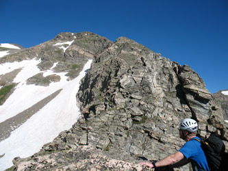 minutes later and we soon made it to the four wheel drive road that leads another 2.something miles to Loch Lomond. minutes later and we soon made it to the four wheel drive road that leads another 2.something miles to Loch Lomond.
There are two gates on the road and the first gate was open, meaning we would get to drive for at least half the way to the lake. The road was in good shape and no real challenge for the Toyota that is, of course, my main ride during the week as well. As we closed on the second gate, there were plenty of trucks parked along the wide spots, leading one to surmise that the second gate, that is alleged to be open from July 15 on, was not yet open. We got within a fifty yards or so but found the road blocked, hence we backed up a few hundred feet before having the chance to turn around. A few more hundred yards, and we too were parked on a wide spot. By the way, when the sign says there is no turnaround, its true . . . just bag it and walk, its just not that far.
 We knew there was an 80 foot rappel about one third of the way up the ridge so we brought a rope and light rock rack to overcome that obstacle. I took the rope and suddenly my light pack was a heavy pack. G had the same issue with the rack that we figured we might need to ascend out of the slot on the ridge although I did suspect, from various readings, that there would be a class 4 bypass around the 20 foot wall that one meets upon completing the rappel. We walked up the road, around the gate and upward toward the lake. I'd been up this course before, during the winter, for a ski descent of Bancroft, its a nice walk or ski, depending on the season. Upon reaching the dam, we scoped out the approach to the ridge and elected to take the direct route. There is, however, a higher lake and if one wants more of a road march, you can swing wide and take a dirt track that leads first off to the east and then back to the west as it ascends the easternmost ridge of the mountain. We knew there was an 80 foot rappel about one third of the way up the ridge so we brought a rope and light rock rack to overcome that obstacle. I took the rope and suddenly my light pack was a heavy pack. G had the same issue with the rack that we figured we might need to ascend out of the slot on the ridge although I did suspect, from various readings, that there would be a class 4 bypass around the 20 foot wall that one meets upon completing the rappel. We walked up the road, around the gate and upward toward the lake. I'd been up this course before, during the winter, for a ski descent of Bancroft, its a nice walk or ski, depending on the season. Upon reaching the dam, we scoped out the approach to the ridge and elected to take the direct route. There is, however, a higher lake and if one wants more of a road march, you can swing wide and take a dirt track that leads first off to the east and then back to the west as it ascends the easternmost ridge of the mountain.
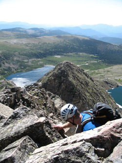
 We took the direct route and meandered our way up the rocky slope and through a gap in the scrub pine to the ridge proper. I should not have been tired from this effort but I found myself huffing at all too low of an elevation. I think it was just too early to wake up after a long work week. Sometimes you just need a day off before taking on a climb, even though you've been thinking about getting out all week long. You know the feeling . . . We walked the gentle eastern ridge to the dam holding back the upper lake and crossed the structure to the base of the northeast ridge. It was obviously going to be a good long scramble with a fair bit of exposure. A nice route. We took the direct route and meandered our way up the rocky slope and through a gap in the scrub pine to the ridge proper. I should not have been tired from this effort but I found myself huffing at all too low of an elevation. I think it was just too early to wake up after a long work week. Sometimes you just need a day off before taking on a climb, even though you've been thinking about getting out all week long. You know the feeling . . . We walked the gentle eastern ridge to the dam holding back the upper lake and crossed the structure to the base of the northeast ridge. It was obviously going to be a good long scramble with a fair bit of exposure. A nice route.
 The ridge starts off at a gentle class 3 level of difficulty and then jumps up a notch to class 4 more or less for the rest of the way to the 1/3 point gap. I chose to get right onto the ridge proper and work my way along its sharp crest. Good exposure to the left and right but for me, just very comfortable hand and foot climbing. We ridge climbed to the gap and were met by a good size marmot, who obviously considered this his realm. Funny thing was he did not seem to have a taste for nylon slings as the boulder which is the anchor for the rappel was festooned with not less than ten slings in all of the available colors. Not a one of them chewed. We dropped the packs, un packed the rope and inspected the slings. I am not a fan of using slings found on any peak to form a rappel anchor but there were so damn many of them . . . could they all fail? The ridge starts off at a gentle class 3 level of difficulty and then jumps up a notch to class 4 more or less for the rest of the way to the 1/3 point gap. I chose to get right onto the ridge proper and work my way along its sharp crest. Good exposure to the left and right but for me, just very comfortable hand and foot climbing. We ridge climbed to the gap and were met by a good size marmot, who obviously considered this his realm. Funny thing was he did not seem to have a taste for nylon slings as the boulder which is the anchor for the rappel was festooned with not less than ten slings in all of the available colors. Not a one of them chewed. We dropped the packs, un packed the rope and inspected the slings. I am not a fan of using slings found on any peak to form a rappel anchor but there were so damn many of them . . . could they all fail?
 Whoever last buttressed this anchor system a great deal of thought and had tied a no less than three rappel rings into the bundle, two equalized as primaries and one as a secondary or back-up. it looked at the slings, pulled at them, and felt then all round . . . not a fray or chew. Perhaps they were all relatively new but as much as a skeptic as I am, I figured they were good to go. The mid point of our 60 meter rope met the rappel rings and went the lines went over the drop with a solid "I'm on the bottom" thump. G rigged his harness and was on rappel. I followed and soon enough we were both down and pulling the rope to re-coil and move on. The now heavy again pack went back on my back and I took a look for the class 4 scramble that would present a route in lieu of the 20 foot class 5.2 pitch that we were facing. Whoever last buttressed this anchor system a great deal of thought and had tied a no less than three rappel rings into the bundle, two equalized as primaries and one as a secondary or back-up. it looked at the slings, pulled at them, and felt then all round . . . not a fray or chew. Perhaps they were all relatively new but as much as a skeptic as I am, I figured they were good to go. The mid point of our 60 meter rope met the rappel rings and went the lines went over the drop with a solid "I'm on the bottom" thump. G rigged his harness and was on rappel. I followed and soon enough we were both down and pulling the rope to re-coil and move on. The now heavy again pack went back on my back and I took a look for the class 4 scramble that would present a route in lieu of the 20 foot class 5.2 pitch that we were facing.
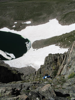
No problem, off to the left is a ledge and after a friction move or two, I was 20 feet up and back on the ridge. G chose another route and a few minutes later joined me on the ridge. I will note that my move was actually in the light realm of class 5 but comfortable for me. G likely kept it to the high end of class 4 . . . but a slip was not an option for either of us as a sliding fall was going to be a fast slide down about 700 feet of snow to the recently thawed lake below. In other words, a slip was not an option that one would walk away from, swim away from perhaps, but not walk for sure.
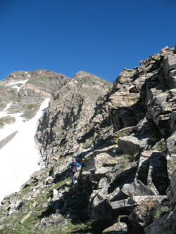
 We continued on the ridge, most all class 4 terrain until we reached a minor saddle that lay just before what I think was the real crux of the climb. A sharp jump up in the ridge the necessitates a shift to the left if one wants to avoid dropping down a steep coulir to the right and then climbing up a steep chimney. I opted to skirting to the left for a few yards and then taking a class 4 slab move up to more solid hand and foot action to regain the ridge. This type of ground continued for another half hour of climbing, a good couple of hundred yards before the route abruptly mellows out at a red dirt saddle. The real climbing is over. We continued on the ridge, most all class 4 terrain until we reached a minor saddle that lay just before what I think was the real crux of the climb. A sharp jump up in the ridge the necessitates a shift to the left if one wants to avoid dropping down a steep coulir to the right and then climbing up a steep chimney. I opted to skirting to the left for a few yards and then taking a class 4 slab move up to more solid hand and foot action to regain the ridge. This type of ground continued for another half hour of climbing, a good couple of hundred yards before the route abruptly mellows out at a red dirt saddle. The real climbing is over.
We took a GU and water break for perhaps 15 minutes before saddling up to climb the class 2 slope to a point where the route nearly flattens before the final summit pyramid. We are now in summer trail territory and a clear path led to the summit proper. Another GU stop for a few minutes and the debate of whether to lug the packs to the summit of Parry Peak, three quarters of a mile and more than a few hundred feet of drop and re-climb away. Marmots and the opportunity to side traverse the summit on the return led us to take the packs and gear along for the walk . . to Parry Peak of course. It is 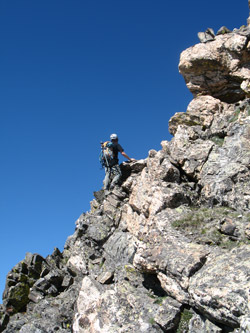 never a surprise how easy it is to walk down a mountain slope to the saddle between two peaks and how hard it is to walk up the other side. Why, once you have the first summit in hand, do any of us walk down and then back up, knowing we really have to do it twice, to score a second summit. Are we simply all peak baggers at heart . . . perhaps. never a surprise how easy it is to walk down a mountain slope to the saddle between two peaks and how hard it is to walk up the other side. Why, once you have the first summit in hand, do any of us walk down and then back up, knowing we really have to do it twice, to score a second summit. Are we simply all peak baggers at heart . . . perhaps.
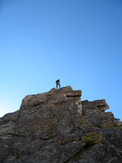
We bagged Parry's summit and ate the required gummi worms at the high point. G placed a single worm on the summit rock cairn for the benefit of Pachamama, regardless of her form . . . raven, marmot, or other. We regained our feet after about 20 minutes and took the reverse of our approach, this time cutting across the contour line to skip the summit of bancroft, been there . . . done that. The terrain presented the "opportunity to excel" at rock hopping until the far slope where it became boulder city until we dropped onto the road that snakes its way up the upper dam. I'm no fool, give me a two track and I will walk a bit further to skip more boulders on the retreat. Pretty soon we are in the teaming fishing camp otherwise known as Loch Lomond on a Saturday . . . there are a dozen folks fishing, arriving, leaving or otherwise. 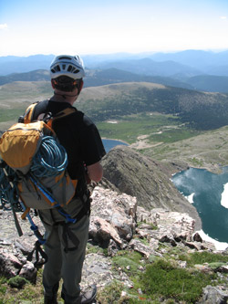 We'd climbed the whole ridge without spotting another soul but trust me the Loch proper is popular. We'd climbed the whole ridge without spotting another soul but trust me the Loch proper is popular.
We hoofed it on back down the road, across the solitary snow patch that the gate keeper likely uses to justify not opening the road. Regardless it is a nice walk, the pine scent was in the air and soon enough we were back at the truck a mile and a half distant. My sandals never felt so good . . . as the day had turned hot and we'd been out for a bit over seven hours. The climb produced a ridgeload (metric system unit wherein the distance is multipled by the derivative . . . how's that calculus fans?) of class 4 climbing, an 80 foot rappel, enough exposed moves to keep our attention and a good day out. Now, to repeat it in the winter . . .
A climb of James Peak, neighbor to Mt. Bancroft . . .
|
