Mount Adams
April 11, 2010 - East Ridge (attempt)
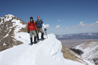
We stood but 300 feet or so from the summit of Mt. Adams and remembered the words of Ed Viesturs as spoken of his attempt of Annapurna. "The risks were just too great." I think that the difference between a peak bagger and a mountaineer is knowing when to listen to the little voice inside that will tell you when there is something out there that you just don't want to tangle with. Such was our climb of Mt. Adams . . . on what must rank and one of the most beautiful Spring blue bird days I've ever experienced in the mountains.
 We left Cheyenne on Saturday night and got a room in Westcliffe for the night. It was an uneventful drive but for the expected and most unwelcome traffic jam on north of the Springs due to some rocket scientist being unable to maintain a safe distance between his front bumper and the vehicle in front of him. No sympathy on my part, that clown cost us a half hour of driving light and a lesser selection of dining in Westcliffe. We arrived at about 8:30 and the pizza joint on the south side of the road coming in to town was closed however we did find a Uruguayan grill right on main street downtown. I'm going to put in a good, no a great word for this place, the food was good and it was warm inside. We left Cheyenne on Saturday night and got a room in Westcliffe for the night. It was an uneventful drive but for the expected and most unwelcome traffic jam on north of the Springs due to some rocket scientist being unable to maintain a safe distance between his front bumper and the vehicle in front of him. No sympathy on my part, that clown cost us a half hour of driving light and a lesser selection of dining in Westcliffe. We arrived at about 8:30 and the pizza joint on the south side of the road coming in to town was closed however we did find a Uruguayan grill right on main street downtown. I'm going to put in a good, no a great word for this place, the food was good and it was warm inside.
 We had a room for the night and were in bed by 10 p.m., planning to get up at 5 a.m. and hopefully be at or near the trail head by six. We knew we needed to get an alpine start but we also knew this would not be that long of a hike and that if we started at sun-up we could have the advantage of navigating the inbound leg with enough light to see the trail cut or tracks of prior passages. I'd read a trip report online that led me to believe that the route to the Horn Lakes was seeing regular winter travel and I hoped that the traffic the other fellow spoke of was still leaving a discernable cut through the snow drifted woods. We had a room for the night and were in bed by 10 p.m., planning to get up at 5 a.m. and hopefully be at or near the trail head by six. We knew we needed to get an alpine start but we also knew this would not be that long of a hike and that if we started at sun-up we could have the advantage of navigating the inbound leg with enough light to see the trail cut or tracks of prior passages. I'd read a trip report online that led me to believe that the route to the Horn Lakes was seeing regular winter travel and I hoped that the traffic the other fellow spoke of was still leaving a discernable cut through the snow drifted woods.
We made our way to the Horn Creek trail head and were quite content to be starting out in warm conditions. But . . . we all knew that warm conditions at the trail head on the morning of a snow climb, means that there likely was not much of an overnight freeze and that there will be slopes to consider, sooner than later, from a wet avalanche perspective. This knowledge in hand, we didn't get away from the car until 6:30 a.m. but we knew it was not that far to the Horn Lakes.
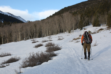
 I'd taken the opportunity to read the Summit Post trail description and I knew there was a zig and a zag to be addressed at the start of the approach hike. We loaded the packs onto our backs, complete with snow shoes and crampons, and were off to get the 4.5 mile approach over with. After perhaps two hundred yards,we arrived at the Rainbow Trail and I knew that this would be our jog to the north. The trail from the vehicle was mostly snow covered but there was a hard track in place and a good patch of ice in any of the soon to be bare spots. At the first junction, we turned right and walked about a quarter mile, with a zig here and curve there, before coming to another junction that had signage pointing the way to the Horn Creek, about one half mile distant. The trail was I'd taken the opportunity to read the Summit Post trail description and I knew there was a zig and a zag to be addressed at the start of the approach hike. We loaded the packs onto our backs, complete with snow shoes and crampons, and were off to get the 4.5 mile approach over with. After perhaps two hundred yards,we arrived at the Rainbow Trail and I knew that this would be our jog to the north. The trail from the vehicle was mostly snow covered but there was a hard track in place and a good patch of ice in any of the soon to be bare spots. At the first junction, we turned right and walked about a quarter mile, with a zig here and curve there, before coming to another junction that had signage pointing the way to the Horn Creek, about one half mile distant. The trail was 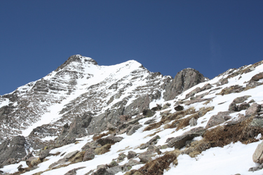 now 95% snow covered for the next half mile until we arrived at the proper start of the trail to the Horn Lakes. At this point, we had gone the better part of a mile and we had a sign that told of a distance of 5 miles to the lakes. So that means we have to go six miles to the start of the real climb, as compared to the 4.5 miles were planning on. now 95% snow covered for the next half mile until we arrived at the proper start of the trail to the Horn Lakes. At this point, we had gone the better part of a mile and we had a sign that told of a distance of 5 miles to the lakes. So that means we have to go six miles to the start of the real climb, as compared to the 4.5 miles were planning on.
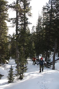
When I say planning on what I really mean is that I told G that we had a 4.5 mile one way trip from trail head to summit and to that he added a casual 3000 feet of vertical. My error and his error combined to equal a long day. It was soon apparent that were really looking at about 13 miles and nearly 5000 feet of vertical. I guess the acronym "PT" just came into the picture and I admit that even a minimal bit of effort in reading the guidebook would help to alleviate such misperceptions. The next mile and a half of the trail was all snow 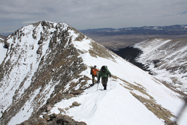 covered but for perhaps 50 yards, near the start, and most all of it was hard enough to support our booted feet sans snowshoes. We'd break through once in a while but not very often as we easily followed the trail cut that was well marked by parallel ski tracks that had been through the melt freeze cycle enough times to form an discernable track. We stayed this course for 1.5 miles before the woods thickened enough to hold the warmer temps of the prior day and night that softened the snow enough to cause us to start post holing, hip deep post holing at this point in the game. The snowshoes came off the packs and went onto the feet. covered but for perhaps 50 yards, near the start, and most all of it was hard enough to support our booted feet sans snowshoes. We'd break through once in a while but not very often as we easily followed the trail cut that was well marked by parallel ski tracks that had been through the melt freeze cycle enough times to form an discernable track. We stayed this course for 1.5 miles before the woods thickened enough to hold the warmer temps of the prior day and night that softened the snow enough to cause us to start post holing, hip deep post holing at this point in the game. The snowshoes came off the packs and went onto the feet.
 The distance into the USFS wilderness boundary is about 2.5 miles from the trail head and at this point the snow was soft enough to require the shoes but not so soft as to make a track more than a few inches deep. The trail cut was obvious through the next mile before we pretty much lost the track and just took a generally ascending course just far enough from the creek to avoid the hills and valleys of snow that filled in the creek bed. We cut a serpentine course through the last of the woods before we finally broke out onto the creek bed where it intercepted a relative tree line. I say relative as we seemed to be in trees forever until they just stopped, while still 30 or 40 feet high. I'm putting my money on the bet that an eastern slope with lots of rainfall and snow makes for a high tree line on the eastern flank of the Sangres. The distance into the USFS wilderness boundary is about 2.5 miles from the trail head and at this point the snow was soft enough to require the shoes but not so soft as to make a track more than a few inches deep. The trail cut was obvious through the next mile before we pretty much lost the track and just took a generally ascending course just far enough from the creek to avoid the hills and valleys of snow that filled in the creek bed. We cut a serpentine course through the last of the woods before we finally broke out onto the creek bed where it intercepted a relative tree line. I say relative as we seemed to be in trees forever until they just stopped, while still 30 or 40 feet high. I'm putting my money on the bet that an eastern slope with lots of rainfall and snow makes for a high tree line on the eastern flank of the Sangres.
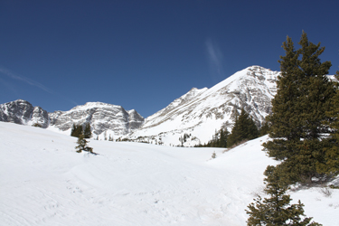
 Once we broke out of the trees, we hiked up the wide and now clear base of the valley, surmounting a hummock or two that I surmise to be short headwalls in the more green season of the year. We were on solid frozen snow at this point but the shoes were already on so we left them in place until we had climbed onto the broad shoulder that seemed to be the logical jumping off point for the climb to the summit proper. Getting to the jump off point was not that easy but after another half hour or so, we were at the base of a large snowfield, dropping our snowshoes and any other extra gear to lighten the packs for the climb to the summit. Once we broke out of the trees, we hiked up the wide and now clear base of the valley, surmounting a hummock or two that I surmise to be short headwalls in the more green season of the year. We were on solid frozen snow at this point but the shoes were already on so we left them in place until we had climbed onto the broad shoulder that seemed to be the logical jumping off point for the climb to the summit proper. Getting to the jump off point was not that easy but after another half hour or so, we were at the base of a large snowfield, dropping our snowshoes and any other extra gear to lighten the packs for the climb to the summit.
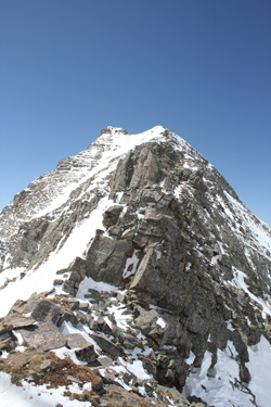
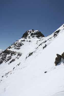
We crossed the large snowfield onto the bare flank of the eastern ridge of Mount Adams which we planned to climb to the ridge line proper. The flank had a snow patch here and there but we pretty much picked a green rather than a white course to the ridge at or about 13k elevation. The trip up to the saddle between Mt. Adams and the adjacent 13 something point was a slog but we all kicked in with a well practiced rest step and were on the ridge after a reasonable time, but late by our standards, noon. We looked up the ridge to the summit and came to two conclusions . . . the ridge was not a class 2+ jaunt as we had heard it would be and it was covered with some quite suspect and now quite warm snow. We knew that this climb would be succeed or fail on any given snow or rock pitch or traverse, which one, we did not know.
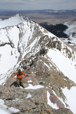
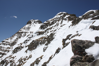 We all knew that noon was a bit late to be taking on this type of ridge, but the sky was blue, we had a solid track out, and we were willing to turn around. This said, we started up the ridge and soon found that the route that we took ranged from class 2+ to solid class 4+. perhaps in the summer this peak presents a clear class 2+ course through the rock, but we were constrained by steep snow fields that either were quite warm and sugary on one side or were the definition of a dicey hard slab on the other. We stuck to the rock and ice, a more predictable combination. We climbed for what ended up being the better part of an hour and a half before ending up on a rock island at the base of the final traverse to the summit block. We all knew that noon was a bit late to be taking on this type of ridge, but the sky was blue, we had a solid track out, and we were willing to turn around. This said, we started up the ridge and soon found that the route that we took ranged from class 2+ to solid class 4+. perhaps in the summer this peak presents a clear class 2+ course through the rock, but we were constrained by steep snow fields that either were quite warm and sugary on one side or were the definition of a dicey hard slab on the other. We stuck to the rock and ice, a more predictable combination. We climbed for what ended up being the better part of an hour and a half before ending up on a rock island at the base of the final traverse to the summit block.
 En route to this point, we'd done a few class 4+ pitches and seen a wet slough avalanche fall through a chute the better part of 1000 feet below the summit. We looked at the terrain ahead of us and Bob voiced his opinion that he had a bad feeling about the rest of the climb. I was not keen on it as the snow was either hard slab or ever wet sugar. G was not keen on descending a few of the rock pitches and that equation all summed to make for the end of En route to this point, we'd done a few class 4+ pitches and seen a wet slough avalanche fall through a chute the better part of 1000 feet below the summit. We looked at the terrain ahead of us and Bob voiced his opinion that he had a bad feeling about the rest of the climb. I was not keen on it as the snow was either hard slab or ever wet sugar. G was not keen on descending a few of the rock pitches and that equation all summed to make for the end of 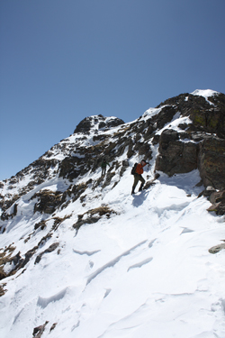 our ascent. Curiously . . . Bob . . . often the "go for it" guy of the crew, voiced that he'd had a bad feeling for 45 minutes and didn't want to ignore the hunch. Long ago, I learned to trust my intuition and when it talks, I listen. We ate a snack about 300 horizontal feet, 100 vertical feet, and one snowfield from the summit.We made a good call as it took us the better part of an hour just to down climb through the rock and ice to the saddle at the base of the ridge. It was now 3 p.m. and we knew we had a six mile retreat to the trail head. There was no light issue as we all had head lamps, and bivy gear, but who really needs to pick one's way out through the woods in the dark on the assumption that the all too warm day did not seriously degrade the morning's inbound track. our ascent. Curiously . . . Bob . . . often the "go for it" guy of the crew, voiced that he'd had a bad feeling for 45 minutes and didn't want to ignore the hunch. Long ago, I learned to trust my intuition and when it talks, I listen. We ate a snack about 300 horizontal feet, 100 vertical feet, and one snowfield from the summit.We made a good call as it took us the better part of an hour just to down climb through the rock and ice to the saddle at the base of the ridge. It was now 3 p.m. and we knew we had a six mile retreat to the trail head. There was no light issue as we all had head lamps, and bivy gear, but who really needs to pick one's way out through the woods in the dark on the assumption that the all too warm day did not seriously degrade the morning's inbound track.
 We returned to the grassy hump to retrieve the snow shoes and were soon on our way out. The snow was now soft, too soft, as we were snowshoe post holing our way back to the trail head. It was 5 p.m. when we stopped to fill our water bottles from the first occurrence of running water and we were still a bit more than 3 miles from the parking area. Once re-hydrated, we kept up a good pace and arrived at the trail head at 6:30 p.m., after 12 hours of travel and about 13 miles, most of them on snowshoes. We returned to the grassy hump to retrieve the snow shoes and were soon on our way out. The snow was now soft, too soft, as we were snowshoe post holing our way back to the trail head. It was 5 p.m. when we stopped to fill our water bottles from the first occurrence of running water and we were still a bit more than 3 miles from the parking area. Once re-hydrated, we kept up a good pace and arrived at the trail head at 6:30 p.m., after 12 hours of travel and about 13 miles, most of them on snowshoes.
We return to Mt. Adams at the end of the summer . . .
|

