|
|---|
Hallett PeakMay 26, 2007 - Tyndall Glacier - Snow
We planned to take a shot at Hallett Peak in Rocky Mountain National Park, via a series of couloirs on its north face. I had spotted this route, christened the Krishna Cutoff by the writer of a portion of the Summitpost.org page for Hallett Peak and thought that since we had experienced such a good snow year, it would be in shape. The route promised steep snow, exposure, and a longish approach to help get the legs in shape.
We took a break at the top of the ridge and then climbed to the summit of Hallett Peak, a summit I had reached perhaps 4 or 5 years before but one that he had not yet accomplished. We looked around and then decided to retrace out route to the top of the glacier, skirt the edge of the snowfield and then cut across the reverse slope of Flattop to climb Ptarmigan Point. this short climb would give us a view into the valley forming the north flank of Flattop and the couloirs associated with that mountain and Notchtop Mountain as well. Perhaps 45 minutes to an hour later we reached the top of Ptarmigan Point and then set off again toward the rounded back of Flattop and down its eastern slope. The trail was exposed where the wind could clear it but much of the route down to tree line was still covered. We reached tree line and battled our way down through the trees until we reached clear trail just 1/2 mile from Bear Lake. The snow in the trees was rutted, cut up, cratered, but still strong enough to support our weight without snowshoes, which we brought along in case of soft snow. We lunched at Ed's Cantina in Estes Park, which was flush with tourists as this was Memorial Day weekend. Hunger satisfied, we were back to Cheyenne a mere 14 hours after we left. |

 Our objective was to start getting into shape for this year's Bolivia trip and this would be our first snow climb of the season. We were a bit late to start the Spring climbing season but personal plans and other travels just seemed to block every opportunity. Regardless, the weekend was nearing and we selected a route to get out and start getting a feel for the gear and techniques that had lain fallow since our return from Bolivia last summer.
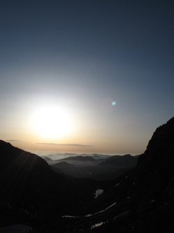
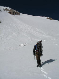 We left Cheyenne at 2 a.m. and made the Bear Lake parking lot at a bit after 4 a.m. We were on the trail toward the Tyndall Gorge and start of our route within 20 minutes of arrival and it seemed as if the sky had started to lighten almost from the start of the hike. We were surprised to see that Nymph lake was ice free and then a bit more surprised to find Dream Lake to also be free of ice. This planted a seed of doubt as to whether our selected route would be in shape after all. We arrived at Emerald Lake to find it frozen and we passed it on the south bank, using a well trod trail, likely beaten by folks heading for the popular Dragontail Couloir on the south flank of Flattop.
 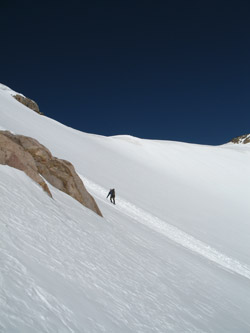 We arrived at the base of this couloir and found that it was filled with snow but it did not look like it had too many more weekends of climbing left in it. We took a look at the base of the "mountaineer's route" on Hallett and though it had snow, we knew that the route would be more rock than snow. One cannot see the routes in the upper part of the gorge from here so we cut left to and climbed up the snow ramp that would put us atop the headwall that is likely more imposing later in the year when there are not snow ramps to make the climb so much easier. We surmounted the wall onto easier terrain and kept climbing around the prow of Hallett Peak and into the upper gorge. We had a print of the face from the internet post but of course it was taken from atop neighboring Flattop and it provided only a guide as the to start point. We kept climbing and when we arrived at the terminal moraine for Tyndall Glacier, we could see the route.
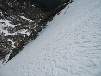 We were late . . . there was snow in the line but not as much as shown on the route photo. The route photo is well done, enough to draw us up the gorge to tackle that line, but we really wanted more snow on the route. We discussed the "go anyway" option, a Tyndall Glacier climb to Hallett Peak, a Tyndall Glacier line to Flattop, and another steep couloir on Flattop. We picked a route on Tyndall as far left or south as we could to get the steepest line of continuous snow available. it looked steep enough to require protection . . . depending upon the character of the snow.
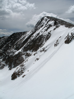 We found about 6 to 8 inches of wind slab, covering a hard layer below. The only avalanche sign we saw was right in front of us, where a cornice had broken loose and brought a portion of the snow with it. We took first to the track of the avalanche, figuring it had cleaned off the wind slab, hence we would not have to kick steps through the crust. However, the cornice did not clean up the slope all that well so we chose our own lines and climbed parallel routes to the crest of the glacier above. The routes likely averaged 55 degrees and had a number of spots where the knees were touching the slope above. my track, more to the left, cut a small cornice about 2/3 of the way up,after which the route steepened for a hundred feet or so before lessening just before the top of the snowfield.