-
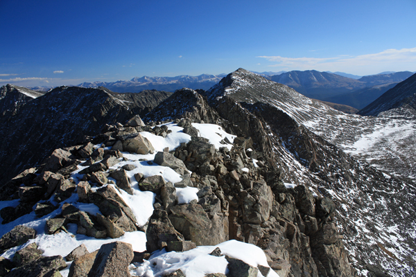
Mt. Bierstadt Group Summit - Front Range, Colorado
-
A rest before the summit push on Dallas Peak - San Juan Range, Colorado
-
Broken Ankle + 6 Miles = Tired
-
The classic San Juan approach - San Juan Range, Colorado
-
Overlooking Noname Basin from Twin Thumbs Pass - San Juan Range, Colorado
-
Upper Noname Basin - San Juan Range, Colorado
-
Nearing Noname Cabin - San Juan Range, Colorado
-
Twin Thumbs Twins - San Juan Range, Colorado
-
Nearing the summit of Pt. 13,736 - Sawatch Range, Colorado
-
Blustery day on Iowa Peak - Sawatch Range, Colorado
-
Morning snow at 15k, Cerro Ramada - Cordillera Ramada
-
Artesonraju from the summit of Nevado Pisco - Cordillera Blanca, Peru
-
February crowds on Gray's Peak - Front Range, Colorado
-
Kicking steps on Cerro Lliani - Cordillera Vilcanota, Peru
-
Final traverse to the summit of Wheeler Mountain - Ten Mile Range, Colorado
-
The long walk to Pachanta - Cordillera Vilcanota, Peru
- banner31
Afternoon at 17k on Cerro Ramada - Cordillera Ramada, Argentina
- banner22
The final ridge on Iowa Peak - Sawatch Range, Colorado
-
Summer summit on Longs Peak - Front Range, Colorado
-
A rest day at the Pachanta Hot Springs - Cordillera Vilcanota, Peru
-
Mind over matter on Mt. Parnassas - Front Range, Colorado
-
Rest stop on Cerro Lliani - Cordillera Vilcanota, Peru
- banner30
Post nap surprise on Cerro Ramada - Cordiller Ramada, Argentina
-
Summit on Cerro Lliani - Cordillera Vilcanota, Peru
- banner23
Ridge walking on Grizzly Peak - Sawatch Range, Colorado
-
Enroute the summit via the West Ridge on Pacific Peak - Ten Mile Range, Colorado
-
Mule train bound for Chilca - Cordillera Vilcanota, Peru
-
Taking in the view from Fletcher Peak - Ten Mile Range, Colorado
-
Hiking on Silverheels - Mosquito Range, Colorado
-
Traversing! Gladstone Peak - San Juan Range, Colorado
- banner24
The best of times at Willow Lake - Sangre de Christo Range, Colorado
- banner29
High Altitude Cerebral Edema? - Cordillera Ramada, Argentina
-
Bound for Chilca - Vilcanota Range, Peru
-
Going alpine light, Holy Cross Ridge - Sawatch Range, Colorado
-
Cumbre! Campa I - Cordillera Vilcanota, Peru
-
Roadside lunch with the best of company - Cordillera Vilcanota, Peru
- banner25
Long ridge walk to the summit of California Peak - Sangre de Christo Range, Colorado
- banner28
Crossing el Rio Colorado . . . in the afternoon - Cordillera Ramada, Argentina
- banner37
Dealing with Fall snows high on Casco Peak - Sawatch Range, Colorado
-
Moonrise over Mercedario - Cordillera Ramada, Argentina
-
Still climbing at 20,900 on Cerro Ramada - Cordiller Ramada, Argentina
-
Talus on Halo Ridge, Mt. of the Holy Cross - Sawatch Range, Colorado
- banner26
Deteriorating conditions on Mt. Arkansas - Ten Mile Range, Colorado
- banner27
After the climb - Cordillera Ramada, Argentina
- banner38
Taking in the view from the summit of Crystal Peak - Tenmile Range, Colorado
-
Topping out on Mt. Arkansas' North Couloir - Mosquito Range, Colorado
-
Glissade on Mt. Arkansas - Mosquito Range, Colorado
-
Hard snow morning on Teakettle Mountain - San Juan Range, Colorado
-
Spring snow announces the start of the climb on Dallas Peak - San Juan Range, Colorado
-
Crossing the Eolus Catwalk - San Juan Range, Colorado

 I left Cheyenne at about 2 p.m. and picked Ed up at his place at a bit before 4 p.m. We made great time to Leadville and dined at Quincy's before going back to the Mayflower Gulch parking lot to camp for the night. I drove to the upper trailhead on the slushy road but opted to drop back to the paved lot for the night. The paved portion is dry, flat and I parked the truck crosswise in front of the truck to block the approach of any inebriated nocturnal denizens.
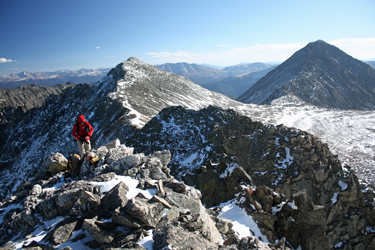 We walked on up the road and cut right toward Villa Ridge, figuring to make our ridge crossing from Drift to Fletcher. I'd been up
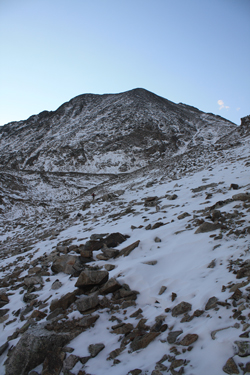
 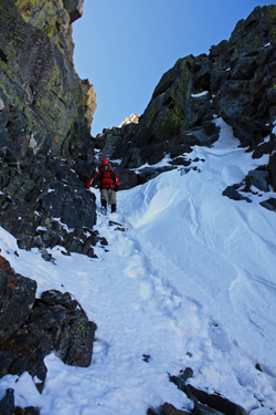 I managed to connect segments of the summer trail, while Ed stayed left and had more of a rock hopping upper ridge. Soon enough we were on the summit where we took a three minute break before moving on to cross the connecting ridge. The ridge starts off with a class 2 traverse of the reverse edge (Mayflower Gulch side) of the scalloped ridge that connects to an intermediate saddle. From this intermediate saddle, one sees the challenge of the route. We found a 40 foot deep cleft with a snow covered class 3/4 climb up the other side. We stashed the hiking poles for the traverse of this section and descended about 40 feet on the Wheeler side and then cut back into the base of the notch. I looked at the given route up the other side and with the snow added, elected not to make the climb.
 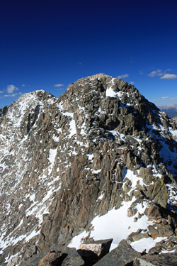 We opted to drop down the Mayflower Gulch side of the cleft, which forms a very narrow couloir that was loaded with some drifted snow but not enough to make the descent very hard. No doubt some attention was required but we needed only to drop about 75 feet as our plan was to skirt the lower edge of the base of the hump and then come back up the other side . . . back to the ridge proper. We skirted the base, found class 2 territory, albeit steep, on the other side and within five minutes we were on the ridge proper. We were now past the one and only difficulty of the entire ridge. From that point on it was nothing more than a hike along the ridge top or adjacent slope to the Drift Fletcher saddle. From the saddle, the summit of Fletcher is but 200 vertical and 15 minutes at the most away. We stopped for perhaps 10 minutes atop Fletcher before moving back to the Fletcher Drift saddle for the drop to the truck far below.
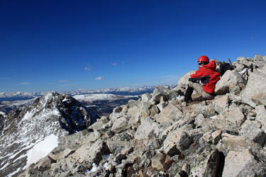 I'd been