|
||||
|---|---|---|---|---|
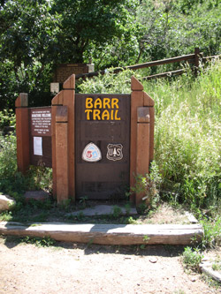
Pikes Peak(two Barr Trail reports > an Attempt and a later Success)April 18-19, 2003 - Barr Trail Attempt
The combination of a Good Friday vacation day and an academic lull before an exam week storm gave me the opportunity to try the Barr Trail route on Pikes Peak. I had done Pikes years ago via the Crags route but the Barr Trail would promise early season snow climbing and possibly the option to ride the cog railway back down. I left Cheyenne around 9 a.m. and arrived at the trail head around 1 p.m. having made a stop for lunch and groceries in Monument. There was no hurry as I had a bunk reserved in the Barr Camp main cabin and figured that as long as I made it there by dinnertime, I would be fine. The Barr Trail starts from a parking lot above the cog railway station and makes its way to the summit of Pikes in about 12 or 13 miles. The Barr Camp is roughly at the halfway point and an elevation of 10,200. The first half of the hike was unforgivingly hot and consisted of climbing what I perceived as endless switchbacks to a trail junction near the top of an old incline railway route. The problem with coming in from Wyoming is that I am programmed for cold. Now, in this case, I am on the trail in Manitou and it might as well be Arizona, the temperature was a sweltering 75 degrees in the sun. Cheyenne just got its first day over 70 this season and I was just not on the ball when I left my nutters (running shorts) at home. Payback came in the form of 1500 feet of toasty climbing.
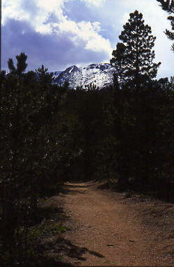
After about 3½ miles, elevation cured my attire problem and the trail straightened and climbed to Barr Camp. The route is wholly in the trees, nicely graded and starts to provide views of the snow laced eastern face of Pikes Peak. I finally hit my stride at this point and thankfully was able to put an overextended “start of trail” attitude to rest. I made the Barr Camp at a bit after five and settled in for dinner around six. There were also three other parties there, two planning snow climbs to the summit the next day and one just going to head down after overnighting in the cabin. It was good company, good conversation and nine p.m. before I knew it. I hit the bunk and set my alarm for o’dark thirty the next morning. The alarm, however, was as much wishful thinking as careful planning. The weather report was calling for 2 to 4 inches of snow and I guessed that would bring attendant low visibility with it. I was aware of this before leaving Cheyenne but I figured that even an aborted trip consisting of an overnight in the hills and a recon of this route would be a success. An early a.m. nature call indicated that the weather had indeed changed and taken a distinctly winter-like appearance. I canned the alarm and figured I would re-assess any thoughts of going further up at dawn. I got up at 6 a.m. and did the mental math: solo + unfamiliar route + lousy visibility + no call for improvement during climb + fresh snow on the rocks = leisurely walk to the trail head instead of a summit attempt. The trip down was a nice walk, first alone through the quiet of fresh snow and then passing numerous hill runners making their way up and down the switchback section. The snow fell off markedly at about the 9000 foot mark but continued to fall lightly all the way down to about 7500 feet. After that, it was just a walk in the rain to the truck.
Barr Trail Success - July 6, 2007
I left Cheyenne, WY, at about 7:30 in the evening and made it to the trail head parking lot just a few minutes before 11 p.m. I knew from a guide book that the trip to the summit and back could take as long as 15 hours, per Dawson. I usually better the Dawson time by an hour for every predicted 8 hours so I figured I was looking at a 13 hour round trip. I knew the summit house (water refill) would not open until 8 a.m. and that the heat wave gripping Colorado might lead to thunderstorms, perhaps even a bit earlier than the standard noon "off the summit" admonition. With an estimated climb of 7 hours, I decided to leave the trail head at 2 a.m. I set the alarm for 1:30 and put the seat into the full recline position, not figuring to get much more than a fitful catnap.
I also tossed a printout of a very well done description of the trail available on line. The guide is made for the Pikes peak Ascent and Marathon but as the author correctly states, it might also be of value to Barr Trail hikers. I figured the route would be crystal clear and I never did look at the description. I set off up the switchbacks and as I remembered they were interminable. Upward and onward I went, eventually reaching the top there is a wide flat spot with a kind of aura that says "the switchbacks of note are behind you." I remembered this spot from my attempted climb four years before and stopped to chug some water and swap the long sleeved poly top for a poly tee shirt. I'd sweated up my back and there was just enough of a gentle breeze to make for a touch of chill. With the sweated up shirt tied to the outside of the pack to dry, I went onward and upward.
I knew I had three miles to go and even if I turned around at this point, I would still equal my personal one day distance record. But, the sun was out and I could see the trail weaving a path back and forth across the east face of the peak, so I was game to continue. The trail remains well graded and I would guess it climbs at a rate of perhaps 600 to 800 feet per mile. I made the "2 miles to go" sign and then the "1 mile to go" marker. I could see the route to the top and hear the sounds of hikers who had driven to the top to come down a bit and then return to the summit (passed them up bound later) to avoid the lengthy retreat down the Barr trail.
The car was there, the air conditioning worked as advertised and I was happy to be off the Barr Trail. Not just because I was hurting a bit but because I knew I had made a respectable climb with almost no stops and no major tiring en route. The trip down became long but all told, the conditioning program I had been engaging in appeared to be working.
Pikes via the Crags Route . . .
|

 With a trip to Bolivia just 4 weeks away, I needed to determine if the hundreds of miles of bike riding, climbing to the extent possible, and new gym membership were having the desired effect. What better way to determine if one can go the distance later than a one day trip up and down the Barr trail to the summit of Pike's Peak now. I knew the round trip distance was 26 miles and 7600 vertical each way and I felt that such a route would assess my training program, for better or worse. Given that I have never gone more than 20 miles in a single day, the Barr Trail would prove to be interesting.
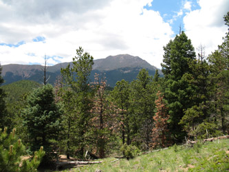 The alarm went off and I laid there for a few minutes asking why I had come to this place, why I was going to solo the route to the top, how bored I would be on the hike up, and whether or not to take the mountain lion advisory sign more seriously. After a few minutes of soul searching, I came up with no better answer than I have expended the time and $ to drive to the trail head and that short of getting eaten en route, it would be a good training climb. The switchbacks for the first three miles would bore me to tears but that if I could force myself as far as Barr Camp, the sun would come up and I would dig deep enough to see a new stretch of trail and make it to the summit. That was my plan.
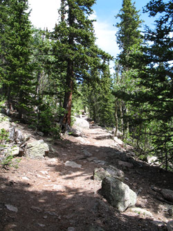 I packed the lunch items I bought in Cheyenne and placed two quarts of Cyto-Max in my pack. I took out the down jacket but kept the Gore-tex shell that would be real handy in case of rain. I threw in an extra pair of wool socks in case I needed something thicker on the way down and grabbed my hiking poles. I hefted the pack, knowing it was three times as heavy as the fanny packs that others would climb with on this promised nice weather day, but I've also been around the climbing block and seen the weather go to crap really fast, seen someone take a slider, and seen someone get turned around enough for an overnight. I decided to carry the extra weight.
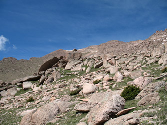 I passed the turnoff for the top of the incline and knew that I would make a creek crossing (pipe under trail) and then climb onto a ridge where the trail would be wide, well graded and relatively level for a number of miles. Relatively level meaning that the trail is barely climbing and you can make a really good walking pace with nary a deep breath along the way. The distance from the creek crossing to Barr Camp is 3.5 miles and once on the "flats", I covered the distance with little real effort. There was not much to see in the dark, nobody to talk to, and little to think about outside of my usual musings about workplace clients, personal foibles and just how bad this 26 mile forced march was going to hurt me.
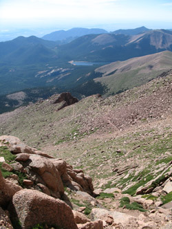 I made it to Barr Camp a bit before dawn and stopped only for a drink and shot of Goo before moving onto trail that I had not walked four years before. The trail begins to ascend again and after some easy going, begins to switchback over and over on its goal to break tree line near the "A Frame" shelter located at that elevation. The distance from Barr Camp to the shelter is three miles and I dropped the headlamp into my pack about a mile past Barr Camp. The switchbacks went on and on but doing them in the light is just so much better than the same course in the dark. You get to see where you are going and gauge the thinning of the forest as you anticipate reaching tree line. The miles did pass and I made it to the shelter and the open terrain above.
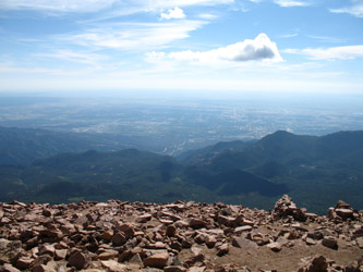 The final switchbacks held remnants of winter snow for a couple dozen feet, necessitating a short climb up well kicked boot tracks to pass one 15 foot snow patch. From there it was just a few yards hike to the summit and the opportunity to get a bite to eat and fill the water bottle for the trip down. I asked the time of a car climber and found that I had made it from the start to summit in about 6:58, right about the duration I expected for a slow and steady pace with stops only for Goo and a drink about 5 times along the way. I rested a bit and then after perhaps 20 minutes on the summit, I walked past the sign that advises that the distance to the trail head is 13 miles.
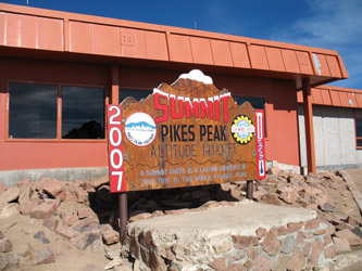 The trip down was uneventful for the first 3 miles or so, after which the knees started complaining that this downhill stuff was not to their liking. I was only carrying a quart of water, figuring to fill at the Barr Camp, hence keeping the weight to a minimum. I trudged along down through the switchbacks below the A Frame and then took a 15 minute sitting rest at Barr Camp. I knew the route from there through the next 3 miles would be pretty tame and easy on the knees but I knew that after that point, it was going to be a effort in pain compartmentalization if I was to have any chance to enjoy the last three miles, especially the last mile of switchbacks to the car. The heat also came on strong as the elevation fell and I killed the fresh quart pumped at Barr Camp about 1/2 mile from the car. I just took the pace down a notch and willed my knees through the last half mile, feeling ever increasing sympathy for the cries of my wife when she too is well exercised at the end of a hike.