Argentina 2010
Summit Day . . . January 17, 2010
(see Google Earth Photo for Route from Torres Rosadas Camp to Summit and Return)
The summit day alarm did what it always does . . . go off too early, too many hours before the sun is up and in the middle of a too darn cold night. This summit day was no different but we all knew it was going to be a good day. G and I had a chance to break 20k and climb to new personal altitude records and Bob, well, he was scoring a new personal high with every step above the half way point between the Lagunita and Vitrola camps.
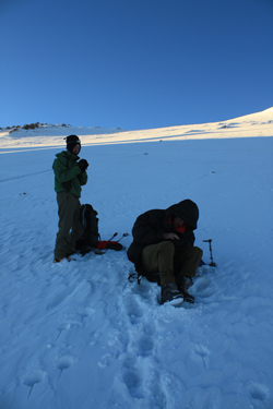 The alarm went off at 2 a.m. and within a few minutes, I was dressed and in the Mid with Manuel, trying to get something warm in my stomach . . . warm Cytomax and some cereal. This was no day for a big cooking effort or a big breakfast to have sit hard on the stomach. G and Bob followed by about ten minutes and by that time I was ready to go stand in the cold. We were down to a multi-fuel stove and Manuel was burning some unleaded gas to melt a bit more snow for hot tea. Judging by the smell, I'd have bet that Manuel was really burning heavy bunker oil from some tramp The alarm went off at 2 a.m. and within a few minutes, I was dressed and in the Mid with Manuel, trying to get something warm in my stomach . . . warm Cytomax and some cereal. This was no day for a big cooking effort or a big breakfast to have sit hard on the stomach. G and Bob followed by about ten minutes and by that time I was ready to go stand in the cold. We were down to a multi-fuel stove and Manuel was burning some unleaded gas to melt a bit more snow for hot tea. Judging by the smell, I'd have bet that Manuel was really burning heavy bunker oil from some tramp 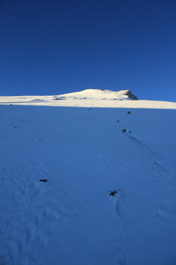 steamer, at least it smelled the part. I took in the fumes for just a few minutes and then bailed to go out in the cold in an effort to keep at least a few red blood cells that still had the ability to link with a two oxygen atoms rather than play out a fatal attraction to a CO molecule. steamer, at least it smelled the part. I took in the fumes for just a few minutes and then bailed to go out in the cold in an effort to keep at least a few red blood cells that still had the ability to link with a two oxygen atoms rather than play out a fatal attraction to a CO molecule.
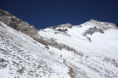
G and Bob took in a bit more carbon monoxide and then they too had enough and stashed some warm water in their packs for the trip toward the summit. Our only handicap was that G had inadvertently left his headlamp in the extra gear bag stashed at the Vitrola camp. I had a headlamp, Bob had one, and G necessarily took up the mid point position in our merry train of three. We knew that there was a trail that left the Torres 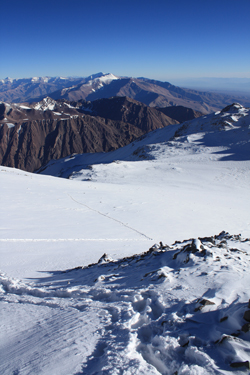 camp as it was visible the afternoon before before the snow started to fall. We knew that it seemed to start about 150 yards from the camp and would cut across the side of the hill, climbing steadily until it reached a rock outcrop. From there on, we knew nothing of the route other than the need to climb to a saddle and then take the ridge to the summit. camp as it was visible the afternoon before before the snow started to fall. We knew that it seemed to start about 150 yards from the camp and would cut across the side of the hill, climbing steadily until it reached a rock outcrop. From there on, we knew nothing of the route other than the need to climb to a saddle and then take the ridge to the summit.
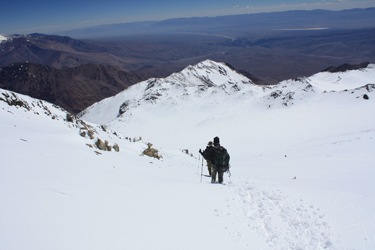
I took the lead as we left about 3 a.m. and within a few stumbling minutes, I scored the tail end of the trail and took the group in that direction. The trail is not a wide path or cairned route, but a narrow track, perhaps no wider than a foot, that traversed and climbed the side slope of the peak. The snow had obscured the trail but for where the wind had blown a shallow swath of snow away from the uphill edge and down against the lower edge. The trail was not itself what I was able to follow but instead I picked my way along 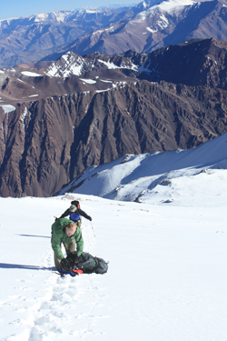 an amazingly discernable shadow produced by my headlamp. We climbed for about a half mile before we reached the outcrop that we had spotted from the camp and the terminus of the route that we knew of. an amazingly discernable shadow produced by my headlamp. We climbed for about a half mile before we reached the outcrop that we had spotted from the camp and the terminus of the route that we knew of.
I stopped at a couloir and looked up . . . was this the route or did I cross what looked like a slough of snow to pick up the trail on the other side of the outcrop? It almost looked like a cut in the rocks that showed some travel, yes, that must be the route. I led across the snow rubble, skipping the opportunity to start up the couloir and instead continuing to traverse. I chose wisely and within another 30 feet, I hit a solid shadow line and on we trudged. We knew that we would lose the shadow at some point and within a few minutes that time arrived. I had input a point into my GPS that was the high camp we elected not to climb to the day before. I noted the direction to that point and we started to climb straight up, kicking real steps up the slope toward the high camp point.
 We arrived in the vicinity of the high camp and never saw any sign of tent pads or a reason to believe there was a camp in the vicinity. Well .. . no matter, I had a point for the break in the ridge, the saddle we needed to hit to gain the upper flank of the mountain and the ridge to the summit. We headed in the direction of the saddle and soon came into the lee of a big boulder. We stopped for a Gu and some water, our first stop of the morning . . . we had been moving for an two hours or so. We added the down layers and took a break and got cold . . . I just couldn't shake the chill so when the packs went back on, I kept the down layer on. Soon enough I was climbing warm but not warm enough to shed that outer layer. We arrived in the vicinity of the high camp and never saw any sign of tent pads or a reason to believe there was a camp in the vicinity. Well .. . no matter, I had a point for the break in the ridge, the saddle we needed to hit to gain the upper flank of the mountain and the ridge to the summit. We headed in the direction of the saddle and soon came into the lee of a big boulder. We stopped for a Gu and some water, our first stop of the morning . . . we had been moving for an two hours or so. We added the down layers and took a break and got cold . . . I just couldn't shake the chill so when the packs went back on, I kept the down layer on. Soon enough I was climbing warm but not warm enough to shed that outer layer.
I doubt the 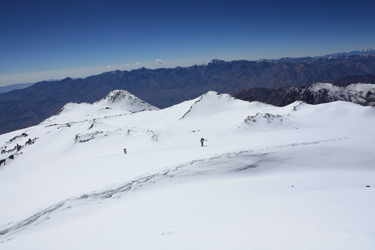 temperature was that low and instead suspected that our elevation of about 18,500 feet had deprived us of enough oxygen that getting warm again after a dark and cold stop would not be as easy as it would be in Colorado. temperature was that low and instead suspected that our elevation of about 18,500 feet had deprived us of enough oxygen that getting warm again after a dark and cold stop would not be as easy as it would be in Colorado.
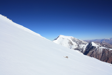
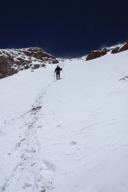
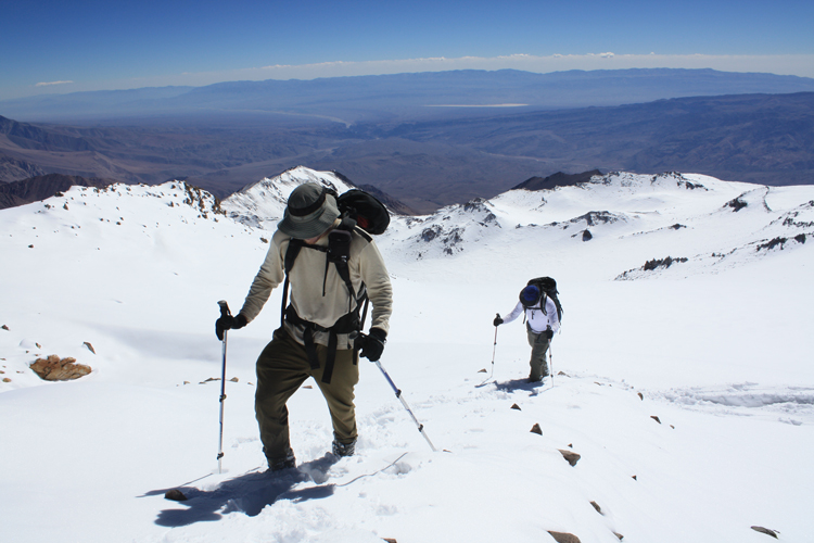
I led toward the known crest and we passed through a pair of penitente riddled snowfields, which we elected to skirt the side of. The ground soon steepened and we realized we were on the final slope before we would crest the saddle and begin the upper portion of the climb. The snow that we received the night before in the Torres Camp was perhaps 5 or 6 inches deep but the snow at this point was every bit of a foot deep and still taking a reasonable boot step. We broke the crest and 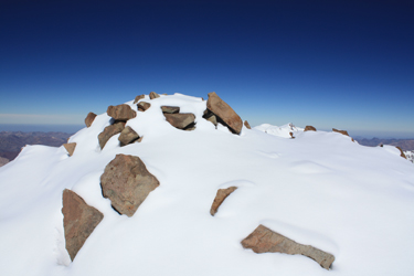 arrived at the flat base of the wide flank of the peak. The sun was now coming up and we knew that while we had 2000 feet to climb, we would be doing most of that climb in the sun and we would not have any issues with the cold. Also at this point, none of us dared whisper the word "wind" as the air was now fairly still in a location that others had routinely called the windiest part of the climb. arrived at the flat base of the wide flank of the peak. The sun was now coming up and we knew that while we had 2000 feet to climb, we would be doing most of that climb in the sun and we would not have any issues with the cold. Also at this point, none of us dared whisper the word "wind" as the air was now fairly still in a location that others had routinely called the windiest part of the climb.
We now had to choose between the ridge that we could see from camp or more of a meander up a less steep flank that none the less would provide a route, albeit more tempered, to the summit. We took the more mellow terrain to the summit, that we could clearly see was just not that far away nor that much higher. 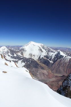 Remember what I said about the illusion of distance? Well, we were getting another lesson. The summit that we saw was a ridge point and the elevation gain between our location and the summit, that was but a mile away, was a solid 2000 feet. It just didn't look that far . . . we were closer than that . . . Remember what I said about the illusion of distance? Well, we were getting another lesson. The summit that we saw was a ridge point and the elevation gain between our location and the summit, that was but a mile away, was a solid 2000 feet. It just didn't look that far . . . we were closer than that . . .
We cut wide switchbacks, trading off the lead and soon stopping to shed the down layer. The lead climber took on a few hundred yards of the deepening snow before silently stepping to the side to allow the next person to take the lead. The third person followed to become number two and the former leader fell into the third or sweep position. We swapped back and forth for a hour or more before we really felt we were making progress. We also now saw the true summit and it was still 1000 feet higher than we were. But what the heck, we were standing at 20,000 feet and within 1000 feet of our goal. We picked out a lone rock and set that as our next goal and we reached it about one half hour later. Then we debated whether to go directly to the summit or to head for a gentle ridge on the hope that there would be a hard layer of snow.
 A hard layer, that was our elusive goal as the snow that fell over the past few nights was now at least two feet deep and sometimes it took a boot step but mostly we were post holing and getting more than a bit tired through the process. We stopped a few times and debated the ridge versus direct and then made the call to head for the ridge. We could see that an extension of the ridge below us was windblown in places and I had it stuck in my mind that it would be the same higher up as well or that the wind would have hammered at least a spine of a cornice that we could find and kick steps up. Bob took the lead, crossed the shallow ridge and went a bit further before sitting down for a break. G walked to a A hard layer, that was our elusive goal as the snow that fell over the past few nights was now at least two feet deep and sometimes it took a boot step but mostly we were post holing and getting more than a bit tired through the process. We stopped a few times and debated the ridge versus direct and then made the call to head for the ridge. We could see that an extension of the ridge below us was windblown in places and I had it stuck in my mind that it would be the same higher up as well or that the wind would have hammered at least a spine of a cornice that we could find and kick steps up. Bob took the lead, crossed the shallow ridge and went a bit further before sitting down for a break. G walked to a 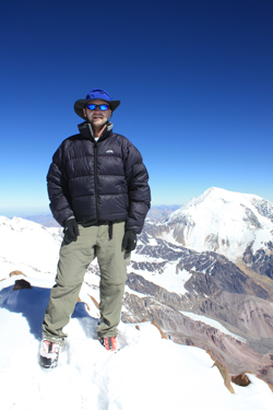 point a bit shy of the ridge and stopped for a break as well. It was now hot and we were all down to white long underwear tops due to the strength of the sun and exertion. I passed G by about ten yards and felt something under my boot, yes, a bit of a hard layer. point a bit shy of the ridge and stopped for a break as well. It was now hot and we were all down to white long underwear tops due to the strength of the sun and exertion. I passed G by about ten yards and felt something under my boot, yes, a bit of a hard layer.
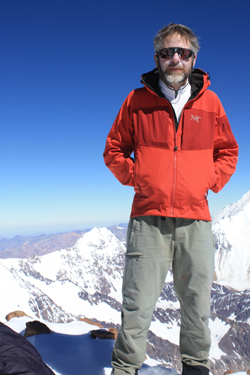
I turned uphill and kicked a few steps, and those steps held . . . I was not post holing. I shifted into the mind over matter 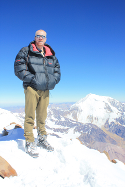 gear and kept going. After about 5 minutes I looked toward Bob and motioned for him to come to my course. G took notice at about the same time and hefted his pack to follow as well. I knew I was within about 500 vertical of the summit and I had solid snow under my feet. Slow and steady, I kept going and when I looked back, I had two in trail, perhaps 100 yards back. Slow and steady . . . no need for a rest . . . the summit was not that far off . . . slow and steady . . . getting closer . . . just five more minutes . . . 250 feet . . . 100 feet . . . almost there . . . and then, I was there . . . on top of Cerro de Ramada . . . 21k. gear and kept going. After about 5 minutes I looked toward Bob and motioned for him to come to my course. G took notice at about the same time and hefted his pack to follow as well. I knew I was within about 500 vertical of the summit and I had solid snow under my feet. Slow and steady, I kept going and when I looked back, I had two in trail, perhaps 100 yards back. Slow and steady . . . no need for a rest . . . the summit was not that far off . . . slow and steady . . . getting closer . . . just five more minutes . . . 250 feet . . . 100 feet . . . almost there . . . and then, I was there . . . on top of Cerro de Ramada . . . 21k.
I dropped my pack and looked back down the trail I'd just made to G and Bob who were making steady progress up the path to the top, but a few minutes away. While they came the final distance, I took some photos, stood in awe of the distance to the valley below and looked south to Aconcagua, knowing for sure that someone on that summit was looking north 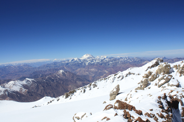 to my location. G and Bob joined me and we all took in the view and congratulated one another on a new high for each of us. We took a few more photos including some photos of me holding the flag of the law firm I am with in recognition of the partners who were holding down the fort while I was climbing in Argentina. After about one half hour on top, we gathered our packs and G led the way down. Due to the warmth of the day and the depth of the ever warming snow, we discussed the avi potential of the route we came up and elected to descend via the ridge, skirting along at the snow/rock interface in case something let loose. to my location. G and Bob joined me and we all took in the view and congratulated one another on a new high for each of us. We took a few more photos including some photos of me holding the flag of the law firm I am with in recognition of the partners who were holding down the fort while I was climbing in Argentina. After about one half hour on top, we gathered our packs and G led the way down. Due to the warmth of the day and the depth of the ever warming snow, we discussed the avi potential of the route we came up and elected to descend via the ridge, skirting along at the snow/rock interface in case something let loose.
 G made good time and set a nice track that Bob and I followed with ease. It was a full 2000 feet of drop back to the saddle and, though we slipped and slid here and there, we had no encounters with any loose snow although we saw the signs of the warming snowpack, the little snow balls that roll down the slope, growing as they go. The ridge route proved to be as steep as we believed it would be when we elected to take our more mellow ascent route. Our choice was certainly justified, though at least one trip report lauded the ridge as the best route. The twist was that others' notes that the ridge was the course of at least a rudimentary trail but in our case, any trail was below at least two feet of snow, making the rules of the scree avoidance game quite different. G made good time and set a nice track that Bob and I followed with ease. It was a full 2000 feet of drop back to the saddle and, though we slipped and slid here and there, we had no encounters with any loose snow although we saw the signs of the warming snowpack, the little snow balls that roll down the slope, growing as they go. The ridge route proved to be as steep as we believed it would be when we elected to take our more mellow ascent route. Our choice was certainly justified, though at least one trip report lauded the ridge as the best route. The twist was that others' notes that the ridge was the course of at least a rudimentary trail but in our case, any trail was below at least two feet of snow, making the rules of the scree avoidance game quite different.
 We made the saddle after about an hour and took a break for fifteen minutes or so. I spoke to Manuel on the radio, which was something we had been doing on the hour for the course of the climb since 5 a.m. We had good communications up to about 20,000 feet and then the topography put an end to our hourly chats until we were back at the saddle. I still made the call, told himwhere where we were but up high there was no response from Manuel. Little did I know that from the reception perspective, Manuel heard nothing but Celeste, at the base camp, was taking it all in. She noted later that when Manuel and I did connect, that it was some of the worst accented Spanglish she ever endured but that she understood every word. Enough said when you can converse back and forth in two languages and pull off every word and sentence. We made the saddle after about an hour and took a break for fifteen minutes or so. I spoke to Manuel on the radio, which was something we had been doing on the hour for the course of the climb since 5 a.m. We had good communications up to about 20,000 feet and then the topography put an end to our hourly chats until we were back at the saddle. I still made the call, told himwhere where we were but up high there was no response from Manuel. Little did I know that from the reception perspective, Manuel heard nothing but Celeste, at the base camp, was taking it all in. She noted later that when Manuel and I did connect, that it was some of the worst accented Spanglish she ever endured but that she understood every word. Enough said when you can converse back and forth in two languages and pull off every word and sentence.
We left the saddle and followed our course back down the slope to the two penitente snowfields, which we again skirted to arrive at a flat area that now, on the way down and in the sun was obviously the high camp we had walked right through in the early morning darkness. We stopped and commented that, given the snow the afternoon before, we were quite content that we elected to stay at the Torres Camp rather than this totally exposed flat. We dropped down past a few rock pinnacles that were vaguely familiar from 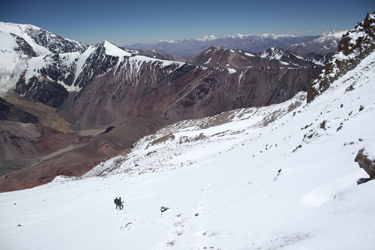 the dark passage and then through the gap that caused a moment of indecision on the way up. Once past that gap, we had the Torres camp in sight and called Manuel to tell him we were about a half hour out. the dark passage and then through the gap that caused a moment of indecision on the way up. Once past that gap, we had the Torres camp in sight and called Manuel to tell him we were about a half hour out.
We decided not to get him started breaking camp as we did not know if we would descend or stay a night at the Torres camp before going all the way to the Base camp the next day. We skirted the side hill and a half hour later dropped into the camp where Manuel had mate and sandwiches ready to go. We decided to eat and take a one hour nap before making the call as to the plan for the rest of the day. An hour later, we were feeling good and it was but four in the afternoon. We decided to strike camp 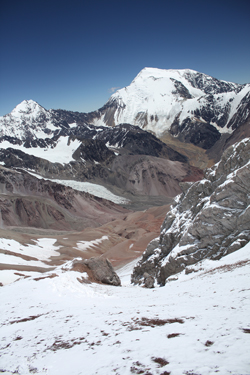 and make for the base of the mountain. We figured it would take 4 to 5 hours to get there and we would arrive in the base camp just before dark. and make for the base of the mountain. We figured it would take 4 to 5 hours to get there and we would arrive in the base camp just before dark.
The tents came down in no time and the gear was soon in the packs for the trip down. We went light on water and figured to water up at the Vitrola Camp. We headed back down the ridge and dropped right onto a series of trail segments, just as advertised but for the fact that they were under a half foot of snow when we made the climb up the morning before. We connected segments and made good time, arriving at the Vitrola Camp after about an hour or so. Manuel said he would grab a gallon of water and meet us at the Lagunita Camp, another 1000 feet below. We kept moving, taking the trail between these two camps and arriving at Lagunita with Manuel but seconds behind us. We shared a mate and some snacks for about a 20 minute rest and then picked up again to make time to the Valle Superior below. We were feeling good and figured if the bodies failed, the Valle had water and lots of flat ground.
 We passed the red towers that had been our aim point on the ascent and again scored trail segments that took us to the Valle proper without the need to talus hop as we did on our way up. As always, the route is more clear when you have the option to look down upon it. We hit the Valle in good shape and there was no doubt that we were headed to the Base camp, but another 800 feet of drop and a mile and half away. The flats we crossed in the Valle felt good but not as good as the guanaco trail that led from the Piedras Coloradas to the red hill above the Valle Colorado proper. We were soon on the red hill and dropping the final bit of vertical to skirt along the bank above the alluvium plain on the trail to the Base camp. We passed the red towers that had been our aim point on the ascent and again scored trail segments that took us to the Valle proper without the need to talus hop as we did on our way up. As always, the route is more clear when you have the option to look down upon it. We hit the Valle in good shape and there was no doubt that we were headed to the Base camp, but another 800 feet of drop and a mile and half away. The flats we crossed in the Valle felt good but not as good as the guanaco trail that led from the Piedras Coloradas to the red hill above the Valle Colorado proper. We were soon on the red hill and dropping the final bit of vertical to skirt along the bank above the alluvium plain on the trail to the Base camp.
 We arrived at the Base and to our surprise Celeste and Multi-Presa were aware of our summit success and that we were headed for the Base camp. Little did we know that our conversations by radio were picked up on her radio as well. She soon had dinner ready and we started to replenish the energy we had spent over the last few days getting to the summit and back. It seemed like we had left so long ago but it was really just a four days and three nights earlier. We had ascended 9,000 feet, been snowed on twice, climbed a normally dry peak when it had two feet of fresh snow blanketing its slopes, weathered an electrical storm at 17k and each scored a personal altitude record. Sitting in the base camp, we could reflect that it had not been a bad couple of days. We arrived at the Base and to our surprise Celeste and Multi-Presa were aware of our summit success and that we were headed for the Base camp. Little did we know that our conversations by radio were picked up on her radio as well. She soon had dinner ready and we started to replenish the energy we had spent over the last few days getting to the summit and back. It seemed like we had left so long ago but it was really just a four days and three nights earlier. We had ascended 9,000 feet, been snowed on twice, climbed a normally dry peak when it had two feet of fresh snow blanketing its slopes, weathered an electrical storm at 17k and each scored a personal altitude record. Sitting in the base camp, we could reflect that it had not been a bad couple of days.
|
