-
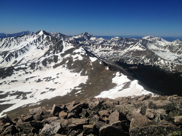
Mt. Bierstadt Group Summit - Front Range, Colorado
-
A rest before the summit push on Dallas Peak - San Juan Range, Colorado
-
Broken Ankle + 6 Miles = Tired
-
The classic San Juan approach - San Juan Range, Colorado
-
Overlooking Noname Basin from Twin Thumbs Pass - San Juan Range, Colorado
-
Upper Noname Basin - San Juan Range, Colorado
-
Nearing Noname Cabin - San Juan Range, Colorado
-
Twin Thumbs Twins - San Juan Range, Colorado
-
Nearing the summit of Pt. 13,736 - Sawatch Range, Colorado
-
Blustery day on Iowa Peak - Sawatch Range, Colorado
-
Morning snow at 15k, Cerro Ramada - Cordillera Ramada
-
Artesonraju from the summit of Nevado Pisco - Cordillera Blanca, Peru
-
February crowds on Gray's Peak - Front Range, Colorado
-
Kicking steps on Cerro Lliani - Cordillera Vilcanota, Peru
-
Final traverse to the summit of Wheeler Mountain - Ten Mile Range, Colorado
-
The long walk to Pachanta - Cordillera Vilcanota, Peru
- banner31
Afternoon at 17k on Cerro Ramada - Cordillera Ramada, Argentina
- banner22
The final ridge on Iowa Peak - Sawatch Range, Colorado
-
Summer summit on Longs Peak - Front Range, Colorado
-
A rest day at the Pachanta Hot Springs - Cordillera Vilcanota, Peru
-
Mind over matter on Mt. Parnassas - Front Range, Colorado
-
Rest stop on Cerro Lliani - Cordillera Vilcanota, Peru
- banner30
Post nap surprise on Cerro Ramada - Cordiller Ramada, Argentina
-
Summit on Cerro Lliani - Cordillera Vilcanota, Peru
- banner23
Ridge walking on Grizzly Peak - Sawatch Range, Colorado
-
Enroute the summit via the West Ridge on Pacific Peak - Ten Mile Range, Colorado
-
Mule train bound for Chilca - Cordillera Vilcanota, Peru
-
Taking in the view from Fletcher Peak - Ten Mile Range, Colorado
-
Hiking on Silverheels - Mosquito Range, Colorado
-
Traversing! Gladstone Peak - San Juan Range, Colorado
- banner24
The best of times at Willow Lake - Sangre de Christo Range, Colorado
- banner29
High Altitude Cerebral Edema? - Cordillera Ramada, Argentina
-
Bound for Chilca - Vilcanota Range, Peru
-
Going alpine light, Holy Cross Ridge - Sawatch Range, Colorado
-
Cumbre! Campa I - Cordillera Vilcanota, Peru
-
Roadside lunch with the best of company - Cordillera Vilcanota, Peru
- banner25
Long ridge walk to the summit of California Peak - Sangre de Christo Range, Colorado
- banner28
Crossing el Rio Colorado . . . in the afternoon - Cordillera Ramada, Argentina
- banner37
Dealing with Fall snows high on Casco Peak - Sawatch Range, Colorado
-
Moonrise over Mercedario - Cordillera Ramada, Argentina
-
Still climbing at 20,900 on Cerro Ramada - Cordiller Ramada, Argentina
-
Talus on Halo Ridge, Mt. of the Holy Cross - Sawatch Range, Colorado
- banner26
Deteriorating conditions on Mt. Arkansas - Ten Mile Range, Colorado
- banner27
After the climb - Cordillera Ramada, Argentina
- banner38
Taking in the view from the summit of Crystal Peak - Tenmile Range, Colorado
-
Topping out on Mt. Arkansas' North Couloir - Mosquito Range, Colorado
-
Glissade on Mt. Arkansas - Mosquito Range, Colorado
-
Hard snow morning on Teakettle Mountain - San Juan Range, Colorado
-
Spring snow announces the start of the climb on Dallas Peak - San Juan Range, Colorado
-
Crossing the Eolus Catwalk - San Juan Range, Colorado

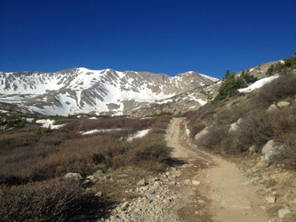 We left Cheyenne on Saturday night and figured to drive up the Baldwin Creek road to find a campsite between the creek crossing and a ways up the road leading to Baldwin Lake. We made it to the start of the 4WD road at 10 p.m. and got to use those off road driving lights that came with the now only newish Xterra. The lights did as advertised, made that 4WD track a daylight adventure, no illumination issues whatsoever. We found a camp spot and within minutes had the tent up and were settled in for the remainder of the night.
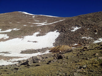 first thing that goes with age is not the body but the alpine start. I'm now 52 and I have to admit that my alpine start is sliding a bit later as the years go by. The alarm was off on time and by 6:15 we were headed up the 4WD track toward Baldwin Lake. The road gains a good bit of altitude with multiple steep sections and then traverses out in the open along a talus slope. The road split and at first we took the high option for about 150 feet. But I stopped when the road cut back 180 degrees and searched the slope above for the next switchback. Didn't see one . . . so we fell back to the junction and took the low road.
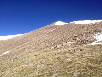 The road continued through the woods and climbed as the vegetation got sparse until we arrived above tree line and at the outfall of Baldwin Lake. I took out the map and for the life of me could make not heads nor tails of the surrounding peaks. Now honestly, I'm not a dunce and I certainly could identify Boulder Mtn. and the scarp that holds Mt. Mamma, multiple intermediate points and Grizzly Mountain. But the topo above the lake is really funky due to the point south of Mt. Mamma having a toe that juts to the lake and pretty much hides half the connecting ridge from view. Well, we'd gotten a late start so the snow slope that led to what I presumed was Grizzly was an option I did not want to bet an approach climb on so it would be Mt. Mamma first.
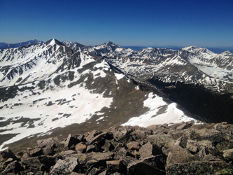 We followed the road on up and around a number of bends and across snowfields to land in the bowl that lies below Mt. Mamma's summit. No doubt as to location due to a mine and its attendant muck pile. Now we needed only mount the slope and we had the first summit in hand. We gained a bit of elevation using a snowfield but then hit the talus and did our best to meander up the most gentle slope possible. Bob was feeling a bit headachy and I was really in no hurry so we zigged our way to the saddle that precedes the summit and then easily climbed the slope to the top. Again, the geometry was just funky as until you reach the summit it appears that Boulder Mtn is higher and for most of the climb the same goes for that first intermediate point on the ridge to Grizzly.
 We stopped for a bite to eat on the summit and after about 20 minutes made the decision to run the almost two mile long ridge to Grizzly. We guessed at how long it would take to make the crossing and figured we had a good two hour traverse coming to us. It was 10:15 and with nary a cloud in the sky, cross we would. The traverse to the first intermediate point was just a drop down to a saddle snow field and then a climb back to the next high point. I was not interested in claiming each individual point so I gained about half the elevation to the sub summit before simply traversing around the slope to pick up the next saddle with little unnecessary elevation gain. The idea worked fine and landed us on another snow slope that led gently to the next saddle.
  Up until this point, the drop off was to the west but the next section of ridge offered a steep cliff ban on the Baldwin Lake side and a gentle slope on the reverse side. The "program" simply reverses so after we crossed the saddle, I again opted to traverse the back slope, making sure to gain elevation along the way but not enough to regain the ridge. As I came around, I could see that my rate of climb was perfect and would land me at the last saddle, which is the base of the climb to the summit of Grizzly. I stepped off the talus after another ten minutes or so and hiked the steep and then gentle slope to the summit proper. The top has a bump of jagged rock that first appears to be the top but in fact one goes on just a bit further to the actual summit.
 Bob joined me after another couple of minutes and we took time for lunch. The crossing did in fact take us just a few minutes more than two hours and with still no clouds in the sky, we were in no hurry to bug out. After lunch, we opted to descend back to the last saddle before the summit and take a direct snow slope back to the willow covered slopes just above Baldwin Lake. The snow was not in the best of shape, pretty warm, but not moving or testy, and not to the point of postholing, except a few times near the bottom. We lost half the necessary elevation in no time and then picked and poked our way through the short willows to the outfall of the lake.
  Piece of cake from there, just hit the road, scored two snow bridges to get across the outfall and an infeeder and hiked the road to the camp. Of course, just hike the road was really about a two mile jaunt with another thousand feet of fall. The cool winds of the upper slopes were now gone and by the time we reached the camp, it felt like summer in Las Vegas. We wasted no time in dropping the tent, packing the gear and heading for someplace where a cold one could be had. We even made it down the jeep road without a meeting with up bound traffic. Overall we were out for almost nine hours, covered the better part of 10 miles and for the second weekend in a row, I walked away with a 2'fer Bicentennial day in the mountains.