Holy Cross Ridge and Mt. of the Holy Cross
August 7, 2011 - Approach via French Creek & Fall Creek to Camp at Lower Tuhare Lake
Holy Cross Ridge was my last Sawatch Range Centennial therefore it made the short list for a predicted blue bird August weekend . . . but for the fact that the Tigiwon Road was closed for the summer, making the use of an alternate trail head a necessity and requiring the whole of the weekend for the climb. To that equation, I added Bob's wedding anniversary and G having to work. Some things can be changed and some cannot, hence I swapped a very productive Saturday morning at the office for the promise of the generally unproductive Monday that follows any extraordinary weekend in the hills. That covered Bob's marital peace while the less frequented French Creek approach covered the hassle of the closed road. As for G . . . I couldn't negotiate his way out of work . . .
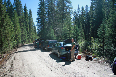 We left Cheyenne at 6 a.m. and were as close as we could get to the trail head by ten. I knew that the road to the French Creek trailhead was also washed out but I was not quite sure how close we would get. The answer was "not real close." We ended up about two miles from the trailhead we were planning to start from. We were faced with the choice of a shorter distance up the Holy Cross Jeep Trail or hiking the road that runs along the aqueduct that we would otherwise have driven. The aqueduct road had the promise of an easy walk and half the elevation gain that we'd ahve to climb if we took the jeep road. We left Cheyenne at 6 a.m. and were as close as we could get to the trail head by ten. I knew that the road to the French Creek trailhead was also washed out but I was not quite sure how close we would get. The answer was "not real close." We ended up about two miles from the trailhead we were planning to start from. We were faced with the choice of a shorter distance up the Holy Cross Jeep Trail or hiking the road that runs along the aqueduct that we would otherwise have driven. The aqueduct road had the promise of an easy walk and half the elevation gain that we'd ahve to climb if we took the jeep road.
 We sorted a bit of group gear, selected the tent du jour and hefted the packs for what promised to be about an 8 mile hike in to the Tuhare Lakes for the pre climb overnight. We figured we would have no shortage of company as the usual mass of parked cars one would find at the Halfmoon trail head had simply shifted south to this trail head. I thought about the odds of finding a good camp site and figured that since we were camping on Sunday night, we'd be fine and most of the car belonged to folks day tripping or soon outbound for the work week. We sorted a bit of group gear, selected the tent du jour and hefted the packs for what promised to be about an 8 mile hike in to the Tuhare Lakes for the pre climb overnight. We figured we would have no shortage of company as the usual mass of parked cars one would find at the Halfmoon trail head had simply shifted south to this trail head. I thought about the odds of finding a good camp site and figured that since we were camping on Sunday night, we'd be fine and most of the car belonged to folks day tripping or soon outbound for the work week.
 We passed by the road closed sign and hiked the quarter mile or so to the large hairpin turn where the Fancy Creek trail head is located. We started uphill in ernest at this point, hiking up what was now a pretty washed out road, as advertised on the closure sign below. We hiked about 200 yards before coming to the culprit, a smallish creek that, like every other creek this summer, had come over its bank to wash out something, anything, just so long as something was washed out. We stepped across the creek on a broken tree trunk and continued on up the road. Above that point, the road was a virtual highway, probably a bit over a mile of good highway until we came to the washout at French Creek. The culvert was washed downstream and the road cut cleanly in two . . . but there was a shallow 4WD ford to the side and a few well located rocks put us on the other side with dry feet. We passed by the road closed sign and hiked the quarter mile or so to the large hairpin turn where the Fancy Creek trail head is located. We started uphill in ernest at this point, hiking up what was now a pretty washed out road, as advertised on the closure sign below. We hiked about 200 yards before coming to the culprit, a smallish creek that, like every other creek this summer, had come over its bank to wash out something, anything, just so long as something was washed out. We stepped across the creek on a broken tree trunk and continued on up the road. Above that point, the road was a virtual highway, probably a bit over a mile of good highway until we came to the washout at French Creek. The culvert was washed downstream and the road cut cleanly in two . . . but there was a shallow 4WD ford to the side and a few well located rocks put us on the other side with dry feet.
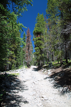
 We walked the last quarter mile to the juncture of the Holy Cross Jeep Trail, where we met a couple of jeepers debating the source of the puff of blue smoke that caught their attention just before our arrival. The road beckoned uphill so off we went, figuring to see just how rough this infamous track really was. The approach to the jeep trail appeared to constitute about 1/4th of the hike in, the jeep trail would be another 1/4th. The route started off pretty tame but did then present the wheeled crew with a series of substantial steps . . . and a sign noting the minimal tow fee started at about $500. The jeepers from below passed us when we took a break for a snack and then we had the road to ourselves until almost the end. We simply followed the drops of fresh oil uphill . . . We walked the last quarter mile to the juncture of the Holy Cross Jeep Trail, where we met a couple of jeepers debating the source of the puff of blue smoke that caught their attention just before our arrival. The road beckoned uphill so off we went, figuring to see just how rough this infamous track really was. The approach to the jeep trail appeared to constitute about 1/4th of the hike in, the jeep trail would be another 1/4th. The route started off pretty tame but did then present the wheeled crew with a series of substantial steps . . . and a sign noting the minimal tow fee started at about $500. The jeepers from below passed us when we took a break for a snack and then we had the road to ourselves until almost the end. We simply followed the drops of fresh oil uphill . . .
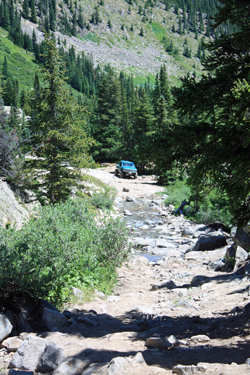
 The jeep trail revealed the oil dripping vehicle after about 1.5 miles, complete with a fellow underneath trying to stem the dripping fluid. Other jeepers were in attendance so we walked on, headed for the French Creek crossing where our trail would part from the 4WD trail and we would enter the Holy Cross Wilderness. Another ten minutes put us at the point where the creek crosses the road and where the boulders would seem to stop all but the serious rock crawling crowd, however between this route and the Wheeler Mountain road, I'm impressed at just how well the barely beyond stock jeeps do on some of this tough terrain. The jeep trail revealed the oil dripping vehicle after about 1.5 miles, complete with a fellow underneath trying to stem the dripping fluid. Other jeepers were in attendance so we walked on, headed for the French Creek crossing where our trail would part from the 4WD trail and we would enter the Holy Cross Wilderness. Another ten minutes put us at the point where the creek crosses the road and where the boulders would seem to stop all but the serious rock crawling crowd, however between this route and the Wheeler Mountain road, I'm impressed at just how well the barely beyond stock jeeps do on some of this tough terrain.
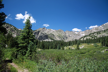
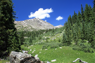
 The French Creek crossing was our cut off toward Hunky Dory Lake, a pretty spot reached perhaps 20 minutes after departing the Holy Cross Road. The trail starts off with a bit of reclaimed two track but then goes to hiking trail proper as it skirts a very pretty valley with the lower end of the Holy Cross Ridge starting to show its character as one proceeds. The next sight was Hunky Dory lake, after which the trail continually ascends and hooks right as it tracks the base of the lower potion of Holy Cross Ridge. The various sub points of the ridge come into view as one proceeds and minute by minute it becomes apparent that this approach to Holy Cross is a hidden gem for sure. We continued up to the vicinity of the lowest Seven Sister Lake, where we stopped for lunch proper, having covered a bit more than half the distance we would have to travel before camping for the night. The French Creek crossing was our cut off toward Hunky Dory Lake, a pretty spot reached perhaps 20 minutes after departing the Holy Cross Road. The trail starts off with a bit of reclaimed two track but then goes to hiking trail proper as it skirts a very pretty valley with the lower end of the Holy Cross Ridge starting to show its character as one proceeds. The next sight was Hunky Dory lake, after which the trail continually ascends and hooks right as it tracks the base of the lower potion of Holy Cross Ridge. The various sub points of the ridge come into view as one proceeds and minute by minute it becomes apparent that this approach to Holy Cross is a hidden gem for sure. We continued up to the vicinity of the lowest Seven Sister Lake, where we stopped for lunch proper, having covered a bit more than half the distance we would have to travel before camping for the night.
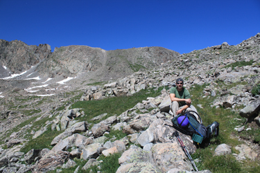
 The route continued up to Fall Pass and the opportunity to fall off the trail to an upper Seven Sister Lake as a starting point for 13,700+ foot Bicentennial, followed by a traverse of the back side of the ridge to Centennial Holy Cross Ridge. We considered the hassle of losing about 500 feet for a camp site at the second to the last Lake but then decided that our climbing objective would not be the Bicentennial and Centennial peaks but the Centennial, for my interest, and a traverse to Holy Cross proper, for Bob. That decided . . . we hiked on to Fall Pass and on down the other side. The Catch 22 of a climb of Holy Cross seems to be that no matter how you do it, you are going to climb 1000 feet back up on the way out. The same is true here as Fall Pass is at 12,500 ft. and the hard turn in the trail that leads up the adjacent valley to Tuhare Lakes is about 1000 feet lower. The route continued up to Fall Pass and the opportunity to fall off the trail to an upper Seven Sister Lake as a starting point for 13,700+ foot Bicentennial, followed by a traverse of the back side of the ridge to Centennial Holy Cross Ridge. We considered the hassle of losing about 500 feet for a camp site at the second to the last Lake but then decided that our climbing objective would not be the Bicentennial and Centennial peaks but the Centennial, for my interest, and a traverse to Holy Cross proper, for Bob. That decided . . . we hiked on to Fall Pass and on down the other side. The Catch 22 of a climb of Holy Cross seems to be that no matter how you do it, you are going to climb 1000 feet back up on the way out. The same is true here as Fall Pass is at 12,500 ft. and the hard turn in the trail that leads up the adjacent valley to Tuhare Lakes is about 1000 feet lower.
 We dropped off the back side of Fall Pass and tracked the wet trail through some small willows and seriously boggy turf before dropping down a short slope and finding the trail awash with the last of the season's snow melt. With the judicious selection of a course connecting the high points of the bog, we were able to cross with dry feet, a true miracle that afternoon. The trail then led not down through the drainage but out and around a smoothed rock hummock and then down through a series of headwalls until we managed to drop about 750 feet of elevation, again something I was not keen on. We were then at the elevation of a stream course that seems to be all that separates one from the trail that climbs, oh so close, to the Tuhare Lakes. We dropped off the back side of Fall Pass and tracked the wet trail through some small willows and seriously boggy turf before dropping down a short slope and finding the trail awash with the last of the season's snow melt. With the judicious selection of a course connecting the high points of the bog, we were able to cross with dry feet, a true miracle that afternoon. The trail then led not down through the drainage but out and around a smoothed rock hummock and then down through a series of headwalls until we managed to drop about 750 feet of elevation, again something I was not keen on. We were then at the elevation of a stream course that seems to be all that separates one from the trail that climbs, oh so close, to the Tuhare Lakes.
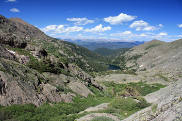
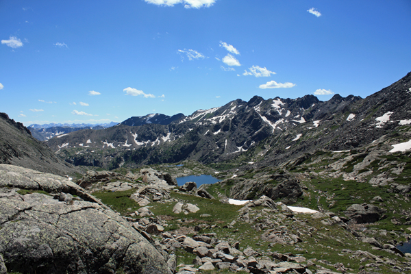
We figured out that it was not a viable crossing and that we needed to take the easy option, stay on the trail, drop another 250 feet of hard earned vertical, and hike back up the other side to the Tuhare Lakes. We crossed the stream on a broken log bridge and took a break at the trail marker denoting our route to the basin we needed to access. Our elevation was now 11,500 ft. and we knew that the lower of the Tuhare Lakes was at just over 12k. The trail up to the lake started out in trees and then after about 1/3 of the distance climbs up through a rocky patch and then skirts a large snowfield. Our route hung 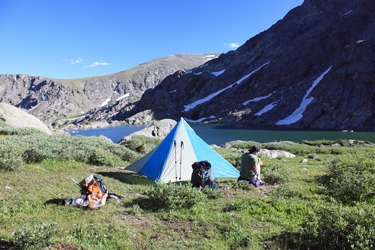 with the rock face on the north of Halo Ridge side of the valley. One passes a beautiful water "slide" drainage the lower Lake before climbing atop the cusp of the headwall and walking to the edge of the Lake. with the rock face on the north of Halo Ridge side of the valley. One passes a beautiful water "slide" drainage the lower Lake before climbing atop the cusp of the headwall and walking to the edge of the Lake.
We skirted the lower lake to the right for about two thirds of its length before finding that there did not appear to be any formal camp sites (meaning the place is not beat to hell) so we cut up into the willows on the right flank and found a dry flat spot that would do for the night. We did not realize it, but we had selected a prime marmot travelway and that we were welcome only if we provided food for the wandering denizens. We opted not to do so, hence we were subjected to multi party squealing and both 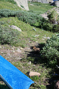 single and multiple marmot charges through our camp in the name of our being in the way and the distinct possibility that we were camping at marmot version of a good place to pick up marmot chicks. single and multiple marmot charges through our camp in the name of our being in the way and the distinct possibility that we were camping at marmot version of a good place to pick up marmot chicks.
We prevailed over about six marmots and set up the Megamid for the night. We've become devotees of the Megamid with its 9 ft square footprint and about one pound of weight in the backpack. The weather has to be right but given a good snowpack or nice summer evening, you cannot go wrong with this quick, and easy shelter. Next came the break with the afore mentioned weight consciousness, a dinner of beef fajitas with onions and peppers, prepared fresh in camp but for the pre-cooked beef strips. By the time dinner was done, the sleeping bags had lofted and we were in the tent for the evening. The alarm set for 4:30 a.m. would go off soon enough . . .
|
