-
Mt. Bierstadt Group Summit - Front Range, Colorado
-
A rest before the summit push on Dallas Peak - San Juan Range, Colorado
-
Broken Ankle + 6 Miles = Tired
-
The classic San Juan approach - San Juan Range, Colorado
-
Overlooking Noname Basin from Twin Thumbs Pass - San Juan Range, Colorado
-
Upper Noname Basin - San Juan Range, Colorado
-
Nearing Noname Cabin - San Juan Range, Colorado
-
Twin Thumbs Twins - San Juan Range, Colorado
-
Nearing the summit of Pt. 13,736 - Sawatch Range, Colorado
-
Blustery day on Iowa Peak - Sawatch Range, Colorado
-
Morning snow at 15k, Cerro Ramada - Cordillera Ramada
-
Artesonraju from the summit of Nevado Pisco - Cordillera Blanca, Peru
-
February crowds on Gray's Peak - Front Range, Colorado
-
Kicking steps on Cerro Lliani - Cordillera Vilcanota, Peru
-
Final traverse to the summit of Wheeler Mountain - Ten Mile Range, Colorado
-
The long walk to Pachanta - Cordillera Vilcanota, Peru
- banner31
Afternoon at 17k on Cerro Ramada - Cordillera Ramada, Argentina
- banner22
The final ridge on Iowa Peak - Sawatch Range, Colorado
-
Summer summit on Longs Peak - Front Range, Colorado
-
A rest day at the Pachanta Hot Springs - Cordillera Vilcanota, Peru
-
Mind over matter on Mt. Parnassas - Front Range, Colorado
-
Rest stop on Cerro Lliani - Cordillera Vilcanota, Peru
- banner30
Post nap surprise on Cerro Ramada - Cordiller Ramada, Argentina
-
Summit on Cerro Lliani - Cordillera Vilcanota, Peru
- banner23
Ridge walking on Grizzly Peak - Sawatch Range, Colorado
-
Enroute the summit via the West Ridge on Pacific Peak - Ten Mile Range, Colorado
-
Mule train bound for Chilca - Cordillera Vilcanota, Peru
-
Taking in the view from Fletcher Peak - Ten Mile Range, Colorado
-
Hiking on Silverheels - Mosquito Range, Colorado
-
Traversing! Gladstone Peak - San Juan Range, Colorado
- banner24
The best of times at Willow Lake - Sangre de Christo Range, Colorado
- banner29
High Altitude Cerebral Edema? - Cordillera Ramada, Argentina
-
Bound for Chilca - Vilcanota Range, Peru
-
Going alpine light, Holy Cross Ridge - Sawatch Range, Colorado
-
Cumbre! Campa I - Cordillera Vilcanota, Peru
-
Roadside lunch with the best of company - Cordillera Vilcanota, Peru
- banner25
Long ridge walk to the summit of California Peak - Sangre de Christo Range, Colorado
- banner28
Crossing el Rio Colorado . . . in the afternoon - Cordillera Ramada, Argentina
- banner37
Dealing with Fall snows high on Casco Peak - Sawatch Range, Colorado
-
Moonrise over Mercedario - Cordillera Ramada, Argentina
-
Still climbing at 20,900 on Cerro Ramada - Cordiller Ramada, Argentina
-
Talus on Halo Ridge, Mt. of the Holy Cross - Sawatch Range, Colorado
- banner26
Deteriorating conditions on Mt. Arkansas - Ten Mile Range, Colorado
- banner27
After the climb - Cordillera Ramada, Argentina
- banner38
Taking in the view from the summit of Crystal Peak - Tenmile Range, Colorado
-
Topping out on Mt. Arkansas' North Couloir - Mosquito Range, Colorado
-
Glissade on Mt. Arkansas - Mosquito Range, Colorado
-
Hard snow morning on Teakettle Mountain - San Juan Range, Colorado
-
Spring snow announces the start of the climb on Dallas Peak - San Juan Range, Colorado
-
Crossing the Eolus Catwalk - San Juan Range, Colorado

 Our original plan was to make an attempt on the east face of McHenry’s Peak. McHenry’s flanks Black Lake in Glacier Gorge and by its summer route, is said to be the most challenging non-technical peak in Rocky Mountain National Park. We were not; however, looking to climb the summer ridge route, but instead we wanted a mixed climb of the east face. For the most part, the route follows a substantial ledge cutting diagonally across the face before it gains the uppermost portion of the summer ridge route.
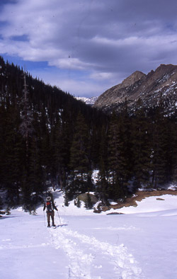
 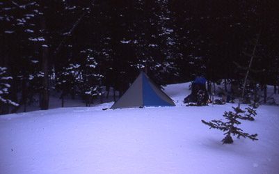 We left the Glacier Gorge parking area a bit later than we hoped for but at least we were Black Lake bound. Would we ever get there . . . a good question . . . as my load was just a pound shy of 50 lbs and G was a pound or two over the mark. Too damn much weight by any standard but we had both cut out whatever we could, short of a shared sleeping bag or other similarly sporting options. We lugged our loads ever upward and about two hours later I was grateful to be wending my way around the edge of Mills Lake, which had some open water and lots of signs that a winter crossing was surely not to be. The time was just a bit past five but we wanted to make it as far as possible before looking for a spot to tramp out a flat pad for the Megamid.
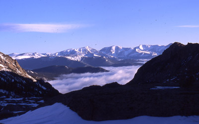 We kept moving over the less challenging ground leading toward Black Lake and were pleased to see patches of open stream here and there . . . hence, the promise of running water. This would come in real handy as we made a weight saving call to bring only enough fuel to heat dinner that evening and a light breakfast before the climb. Any snow melting effort would be a terminal event as to the potential climb the next morning. We finally made Black Lake and found a bivy spot off in the woods that had a great spot for the Megamid and was not too far from a thinly iced water source. The ground got stomped,
 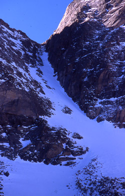 the "mid" was raised and dinner followed in short order. After dinner we both constructed a means to stabilize us on our sleeping pads rather than the snowy tent floor. We called it a night.
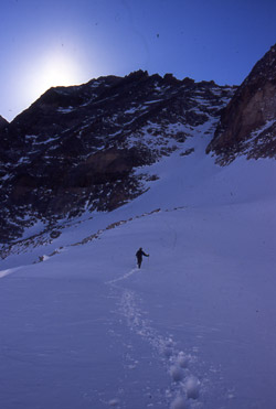 lighter packs and headed up the steep but short headwall to Black Lake proper. Our route took us around the lake and then up to the high ground nearing the exit Long’s Trough route. As we left Black Lake, we could see that the exit from the East Face route on McHenry’s was nicely corniced and the base of the climb was littered with avalanche debris. We knew it would end up a warm day and McHenry's east face just did not look like a route to be on when movement became the norm. So much for McHenry’s . . . onto Chiefs Head.
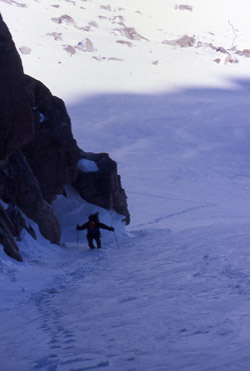 We figured there were two viable routes to the top of Chiefs Head, the east couloir splitting the peak from Pagoda’s west ridge and the large diagonal ledge forming the more northerly boundary of the northeast face of Chiefs Head. We kept climbing toward the decision point and stopped to decide once and for all as we passed around the
 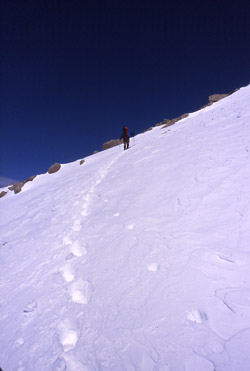 flank of Spearhead. Both routes were well snow loaded but the sloping ledge seemed to have all of the avalanche debris and we knew that to be a more technical route. We had just gotten the sun hit and out of a need for avalanche caution, we chose the east couloir as a faster route that would not warm much over the course of the day, i.e. still cold on our return.
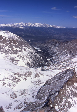 We cut a circular course to the base of the couloir and G cut trail to the point where the couloir begins to narrow. The snow was deep and our steps sometimes approached the point of postholing. We had dropped our snow shoes at the base of a large boulder in order to save a bit more weight, of course at the risk of posthole party on our return. At about the half way mark, we swapped leads and I kicked steps to short rocky band that marks the conclusion of the couloir climb. There was a wide variety of snow so it was not hard to maneuver a bit left or right here and there to find the perfect step kicking conditions. The couloir probably does not exceed 40 to 45 degrees inclination and given the amount of powder, we did not consider protecting the ascent. We wended our way through the rocky band and then stopped for a rest in the cleft dividing Pagoda from Chiefshead.
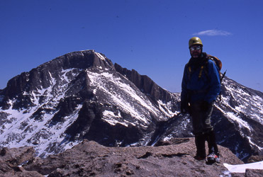 We assumed that the southern flank of Chiefshead would be talus walk and we were correct. We alternated between tame boulder hopping and snowfield traverses to attain the summit of the peak. From the top of the couloir, it is a fair traverse to the summit but gentle terrain the whole way. We celebrated the summit with the traditional gummy worms and photos and after 15 minutes, we retraced our steps across rapidly deteriorating snow to the top of the couloir. We gathered a few pieces of gear left earlier and plunge stepped our way down the couloir to the lower slopes. At that point the sun had warmed the snow
 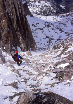 enough to make each step a two-foot deep powder wade and we took the precaution of spreading out in the event something started to move. Soon enough we were back in the lee of the huge boulder below the Spearhead gathering the gear dropped earlier to cut some of the load going up hill.
 Our course back to Black Lake was across softening snow but since we’d brought the snowshoes to the big boulder, there was no postholing to slow us down. We gained our camp and after a good lunch, we packed the overnight gear and again took on the full load for the trip to the parking lot five miles distant. We made our way down through the gorge and, with every foot of elevation lost, the snow deteriorated and the going got tougher. So long as we stayed on the packed trail, all was well, leave the trail, even in snowshoes, and postholing was the name of the game. It ended up being a long sore shoulder slog for me to the parking lot but we did score another RMNP 13’er summit, another snow climb, and more conditioning in preparation for our upcoming trip to Peru.