|
||||||||||||||||||||||||||||
|---|---|---|---|---|---|---|---|---|---|---|---|---|---|---|---|---|---|---|---|---|---|---|---|---|---|---|---|---|
Banff Assiniboine Expedition IIEnroute to the Columbia Icefields, August 1 & 2, 2003:
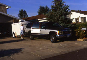
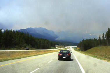
We met at my home in Cheyenne for a planned 0700 departure and by 0730 we were on our way north to Canada. I’ll start with a public note of thanks to my father for the loan of a Suburban which greatly facilitiated getting three people and all their gear in one vehicle with room to spare. Our plan for the first day was to get as far as possible, hopefully into Canada but there was no reason for a straight through drive due to the awkward arrival time that would entail at the Icefields. We did, however, have one stop enroute to drop a trailer in Billings, MT, a sort of quid pro quo for the use of the vehicle. The trip north was uneventful and by early evening we were at the border and about to get the bad news on the Canadian fire season. We pulled forward to the border control booth and after a cursory examination we were told that Banff, Jasper, and Kootenay National Parks were all setting restrictions on back country use due to severe fire danger and ongoing firefighting efforts. This was not good news but we were flexible enough to hope that somewhere along the range of the Canadian Rockies, there would be gaps where decent consolation climbs could be cobbled together in the event our primary climbs were closed. The signs were ominous however, as the sky was colored by smoke from the Glacier Park fire on our side of the border and another large blaze currently closing access to the entire Crowsnest Pass area.
While we were at the border we were also “invited” to park the truck and bring our bear spray and passports inside for a more thorough inspection. The spray was fine (most was bought in Canada the year before) and none of us turned out to be wanted felons seeking to flee the US or otherwise create mayhem in Canada. Given that the immigration officer had to check out our documents, I thought it only fair that he stamp our passports (good souvenir), a request that he laughingly complied with by issuing each of us a Canadian flag lapel pin and a visa to enter and remain in Canada for a whole year. Now that is a lot of climbing! We finished our first day’s travel in Lethbridge, AB, finding a budget motel on the main drag for the evening. The smell of smoke was heavy in town and the front page of the paper at the front desk left little doubt in our mind that our northern neighbors were enduring the same type of fire season that we had endured in the States the previous summer. The next morning we continued a few hours north to Calgary and made our initial grocery buy before heading on to the Icefields. The mountains proper start about 40 miles west of Calgary and we had another stop or two to make before heading up the Parkway to find a campsite for the evening. Our second stop was at GearUp in Canmore to rent a pair of double plastic boots for Ed to use on the first half of the trip. Then we were off to cover the last 100 miles to the Wilcox Creek Campground, out of which we would climb Mount Athabasca the next day.
Our trip unintentionally overlapped a Canadian three-day holiday and our effort to find a camp spot on Saturday afternoon was predictably not going to be easy. He hustled as well as we could but still found ourselves skunked at both the RV and the tent only campgrounds located just south of the Icefield Center. We stopped by the Park’s desk and found that our best shot at a camp site lay 25 km south, a bit more of an early morning commute to the climb than we really wanted but realistically our only choice at the time. We read the climber’s log to assess the conditions on our intended route and then departed south in hope of finding a site at the more remote Rampart Creek Campground. Our efforts were successful, we secured a spot for the evening and then set about organizing gear and eating a hearty burger and Italian sausage dinner. After 1½ days drive, imminent fire closings, and the threat of a campground debacle, we were ready to climb the next morning.
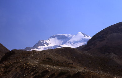
Mount Athabasca, August 3, 2003(Silverhorn Route – Canadian Grade II)
Our initial peak list did not include Mount Athabasca however after some detailed research on the approach to Mount Joffre, we made the substitution. The approach to Joffre appeared to require more time than we wanted to use and we knew that a camp close to Athabasca would allow a full day climb with no approach issues at all. Also, a recent issue of Rock and Ice magazine had a good article by Barry Blanchard (Everest/new route on Robson, etc.) detailing the Silverhorn route as a fine intermediate big mountain climb and we were interested in this line as we had given it a hard look the previous summer. Without further delay, we were off to the same summit but by way of a tougher line than before. Coincidentally, Ed had never been on a glacier before and if you are going to break in a new team member to glacier climbing, why miss the opportunity to launch him right onto a 50 degree blue ice climb . . . as compared to a more casual glacier hike. Kind of sorts out the team members early on in the trip.
We set the alarm for 1 a.m. and promptly broke camp for the day’s climb. We were on the road to the trailhead by 2 a.m. and thankfully, this year, the gate to the parking area adjacent to the moraine was open, cutting 1½ miles off the total length of the climb. However to our surprise, there were already eight cars parked at the trailhead’s wide spot when we arrived, leaving no room for the Suburban. There was apparently a good size group planning an all out assault on the North Face of Athabasca and we arrived just a few minutes after they did. But, we were in Canada and those climbers are one hospitable bunch, two hopped in their cars, moved them in tight to one another and made us a spot. Now tell me, when was the last time you got that kind of slack in the Longs Peak parking lot? Actually, I generally cannot say enough good about the Canadian climbers we met on this trip and the last. To a party, they were giving of information, considerate in climbing, and just damn good company when socializing after the climb.
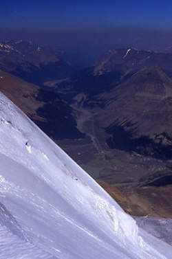
We hoisted our packs and headed up the brutal approach to the glacier high above. The route to the glacier does not access the toe directly but instead takes one to a point about 1/3 of the way up the ice via a sinuous trail that completes fully 1/3 of the total altitude of the climb. The route finding is simple, even in the dark, but for the climbing of a crumbly headwall about ¾ of the way to the glacier. This challenging step is a mass of braided trails through talus and scree and, once again, we did not find the best route for our approach. We did better than last year by avoiding the direct assault up a class 4 gully but we did not connect with the easiest path which can make this portion of climb a simple rest step evolution. After the highwall, we continued up the moraine to the snow filled hollow that last year marked the start of the snow/ice portion of the climb.
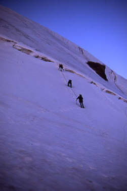
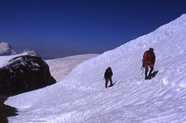
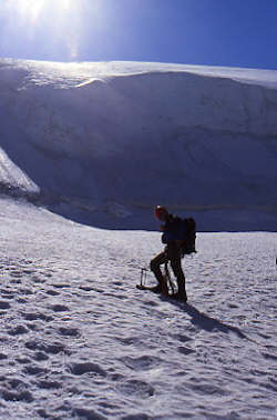
It was still dark when we reached the snow bowl so we dropped our packs to leave behind extra gear (hiking poles) and to rig for travel across the glacier. Our pre trip training had included some practice of roped travel so everyone was familiar with the drill and we needed only to make some minor adjustments before everyone was rigged for a crevasse rescue and ready to go. We crossed the snow and found . . . rock. The past winter had been very dry and the result was that the darkness of our early approach hid the fact that the snow that normally formed the next two hundred yards of travel was entirely gone this year and that we had geared up a bit early for the present conditions. No matter, we fell into the short rope drill and wandered up the last portion of rocky moraine to the glacier proper. As lead for this climb, Gary planned to follow the same route as last year to the base of the uppermost headwall, after which, we would turn left instead of right and climb to the base of the Silverhorn. We made steady progress and crossed over several multi foot wide crevasses, each covered with a firm bridge of frozen snow that supported each of our weights in turn without any problems. We continued up the rolling glacier and made it to the trail junction where the Normal Route path veers right and crosses over the bergschrund in the direction of the AA col. We cut left instead and climbed a 30 to 40 degree slope of neve snow, gaining perhaps two hundred vertical feet before halting at the base of the Silverhorn. The Silverhorn is one of the classic Canadian Rockies routes and can vary in condition from a kicked steps on snow affair to a full blown ice screw and two tool late season event. It was August 3rd and we had both wishes for the first scenario and prior warnings of the second.
At the base of the climb we met a group of climbers who would ascend before us and unwittingly act as a visible barometer of the conditions we could expect. Our groups rested a bit and then the others were off to cross the first challenge, a bergschrund guarding the base of the climb. The trench was bridged by a plug of frozen snow that they crossed on all fours before climbing a few feet to the icy slope beyond. The key word here is icy as we quickly noticed that they remained in a crouch and started climbing, each using an alpine axe in each hand to gain purchase on the frozen slope. No neve here folks, blue alpine ice. We rested while they hammered and beat their way up the first few hundred feet of ice and then crossed onto gentler terrain where they began to stand and walk onward to the base of the second steep pitch. Now it was our turn.
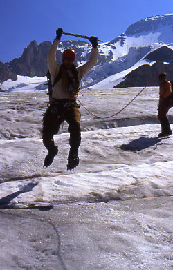
Gary led across the ‘schrund which was solidly bridged and then onto the blue ice slope above. He placed the first of many ice screws and headed up, with Ed in trail. I followed and our rope made its way slowly up the slope, each of us using the axe/crampon technique we felt most comfortable with. Ed being new to this game was a Germanic front pointing fanatic (two alpine axes) while Gary took a more American tack, points on one foot and side step (one alpine axe and one 30 cm ice tool) for the other. My technique was the classic French technique using both feet in a pigeon toed fashion (one alpine tool and one BD 50 cm. Shrike), either way, we placed all the screws whoever was in the lead had and then allowed the sweep to play through, placing the recovered screws until the lead switched again. While we were climbing, the group ahead of us dealt with their own problems as they appeared to be climbing the slope with no protection. They beat the ice to bits as each seemed to be intent on getting the most for every axe placement. Now if you are going to climb 50 degree ice without pro, that is a very good idea, considering the fall potential of over 1000 feet that they were facing in the event one of their party got loose on the slope.
We ascended dodging their dinner place size missiles and keeping our line offset to avoid a re-enactment of the Mount Hood scenario where the sliders took everyone below them for a ride. With steady effort we crossed over the break of the slope and were able to climb the lesser angled snow to the intermediate berschrund and the base of the second steep pitch. The group ahead of us still appeared to be doing it the hard way and when we got to the second ‘schrund, we simply laid low until they again cleared the top of the slope. In the mean time, they did manage to send one slab into my shoulder blade and put a ping pong ball size chunk into Gary’s chin but we did manage to avoid the circular saw blades that whizzed by our position, cutting through the air with a wicked buzzing sound. Once the other group cleared, we began our progress anew and found the second slope to be a longer version of the first, blue ice ranging from 45 degrees on average to occaisional rolls upward of 55 to 60 degrees. One tool, two tools, pointing or walking, we all made it up in our own style, continuously protected by well placed ice screws in the event of a gravitational mishap.
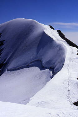
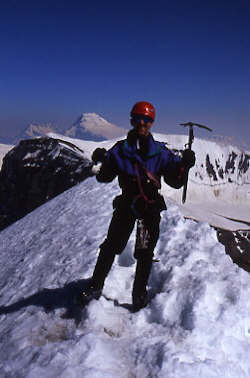
The top of the ice slope placed us on the summit ridge where the Silverhorn route intersects with the upper portion of the Normal Route and where the summit trail meanders off on its gentle climb to the summit cornice. We pulled in the slack and short roped our way along the ridge at a good clip, given the snow was warming and we had been on the Silverhorn a bit longer than we had intended. The summit came quickly and after congratulating Ed on his first ascent of a glaciated peak, we had a bite to eat, took some photos, and packed our gear for the descent. Our route down would be the Normal Route and we were familiar with the line from the previous year.
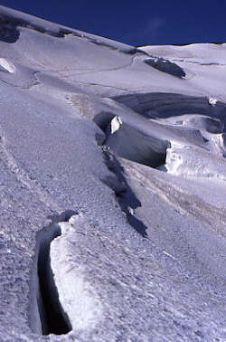
I took the front of the rope (leader on tail end going down) and we descended the scree covered rock shoulder of the peak and out onto the upper portion of the main glacier. We took the long sweeping route down toward the base of the upper serac band and crossed below the hanging ice at a steady clip. The idea was to get through this dangerous portion of trail as quickly as possible and coincidentally, cross the biggest bergschrund of the bunch in the process. The ‘schrund had a big plug of snow in it and we downclimbed perhaps 8 feet into the trench to get across the plug and on out the lower side. The crossing over this gaping hole was uneventful but we kept moving none the less to reach the safest ground back near the cut off to the start of the Silverhorn. Once on safe ground, we took a water and Goo break and then were off again, heading toward the wide slopes of the lower glacier.
The final trudge across the glacier was made lively by the warmth of the day melting out eh snow bridges that we had used to cross the crevasses on the way up. We did a bit of weaving to find the narrow spots, fed out a bit of slack and went a jumpin’. The widest was only three feet but it was fun regardless to hop across these open cracks into which one can look down on the way over. Once across the lower crevasses, we walked to the moraine and sat down for an extended rest before going on down through the broken headwall to the truck far below. Our ascent of Athabasca via the Silverhorn was a success, required a Canadian full day (14 hours), and provided Ed with his first taste of glacier and ice climbing.
Following the climb, we stopped by the Icefield Center to get a bite to eat. The hope was that the Chinese restaurant would be open but it did not open for another hour and we were seriously hungry, hungry enough to settle for the cafeteria’s version of Chinese food (point at the picture style menu). We ate well and then headed south 100 miles to camp near our next climb, Mount Victoria. The camp spot however was not going to be at the lake Louise campground proper, but instead at the overflow Jim and I had used the previous year. Plenty of room for campers of all types . . . none other than Chateau Gravel Pit!
|

