French Mountain
June 5, 2010 - Spring Snow- East Slopes
The work week, though only four days long following Memorial Day had been long enough to make a two day climbing weekend a virtual necessity. G was bound for Canyonlands on an annual pilgrimage with the family and Bob and I were off to the Sawatch to catch some snow climbing. We were aiming for French Mountain, a peak that I had tried to climb in October along with Casco Peak but was driven off by winter weather, and the Grizzly Couloir on Grizzly Peak.
 Bob worked until 6 p.m. on Friday night so we planned a 7 p.m. departure from Cheyenne. that makes for an arrival at 0:dark:30 somewhere outside of Leadville. I suggested that we climb French Mountain first because I knew we were closer to the Halfmoon creek camp sites than we would be to anything in appropriate to a climb of Grizzly. I also figured that Grizzly would be a harder climb so why not get a full night's rest after taking on the less challenging French. We arrived at one of the roadside camp spots at 11:00 p.m. and pitched the tent for a short night, six hours. I would normally get an earlier start but we are still early in the afternoon thunderhead arena and I was just plain tired. Six hours isn't a lot of sleep for this 50 year old body, especially on the ground after a tough week . . . but it would just have to do. Bob worked until 6 p.m. on Friday night so we planned a 7 p.m. departure from Cheyenne. that makes for an arrival at 0:dark:30 somewhere outside of Leadville. I suggested that we climb French Mountain first because I knew we were closer to the Halfmoon creek camp sites than we would be to anything in appropriate to a climb of Grizzly. I also figured that Grizzly would be a harder climb so why not get a full night's rest after taking on the less challenging French. We arrived at one of the roadside camp spots at 11:00 p.m. and pitched the tent for a short night, six hours. I would normally get an earlier start but we are still early in the afternoon thunderhead arena and I was just plain tired. Six hours isn't a lot of sleep for this 50 year old body, especially on the ground after a tough week . . . but it would just have to do.
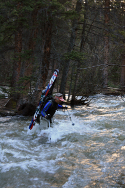
The alarm went off at 5:00 a.m.and I was able to rouse my alpine start. The tent was down and I looked at the clock in the dash of the truck as we pulled away from the campsite . . . 5:12. We drove the few miles up to the Halfmoon Creek trail head and parked. I was not trail ready, meaning I still had to dig around a bit to gather what all I was going to haul along 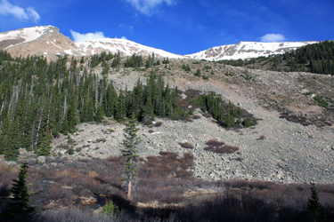 on the climb. I dumped Cytomax mix into the camelback and sorted through the rest of the gear to fill out the pack. We had taken notice of Halfmoon Creek . . . I mean how could we not, it was all one could hear. The spring melt was on full bore and we grabbed the packs and walked to the crossing point to take the log bridge across the stream. The problem was that the log crossing was either gone or far enough under the torrent that we could not see any trace of a crossing. on the climb. I dumped Cytomax mix into the camelback and sorted through the rest of the gear to fill out the pack. We had taken notice of Halfmoon Creek . . . I mean how could we not, it was all one could hear. The spring melt was on full bore and we grabbed the packs and walked to the crossing point to take the log bridge across the stream. The problem was that the log crossing was either gone or far enough under the torrent that we could not see any trace of a crossing.
I walked back to the truck and grabbed my Teva sandals. Bob and I discussed the crossing and felt it was no worse than the worst one we did in Argentina (crossing photo) a few months back. Yes, we could wade this one for sure. I went 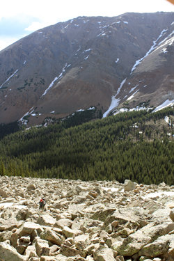 down to my u/w and Tevas for the crossing and stopped at the bank to consider just how cold the water would be and that, like Argentina, I could hear rocks being moved downstream by the current. I crossed at the vehicle ford figuring wide would give the best chance of a successful ford, not that failure was really an option. I made my way across stabbing poles and leaning upstream, one step at a time until I could climb onto the opposite bank. My legs should have been blue if they weren't already as that was one cold crossing. I staggered over to where the log crossing should have been and tossed the Tevas across to Bob so he could follow. down to my u/w and Tevas for the crossing and stopped at the bank to consider just how cold the water would be and that, like Argentina, I could hear rocks being moved downstream by the current. I crossed at the vehicle ford figuring wide would give the best chance of a successful ford, not that failure was really an option. I made my way across stabbing poles and leaning upstream, one step at a time until I could climb onto the opposite bank. My legs should have been blue if they weren't already as that was one cold crossing. I staggered over to where the log crossing should have been and tossed the Tevas across to Bob so he could follow.
As Bob prepared to cross, a threesome of skiers made their way across as well, no doubt sharing our thoughts about the height of the water and the temperature. Bob followed with success and we both warmed up the legs a bit before getting the below the waist layers back on and starting up the road to the base of the French/Casco group. Given the known possibility of another stream crossing in just a mile, I cinched the Tevas to the outside of my pack and we were off.
 The route up to the base of French follows a mining road for about the first three miles, the substantive majority of the guidebook route, but for the slope the ridge leading to the summit. I'd been up the route as far a the valley floor twice before and knew that there was another stream crossing in about a mile, facilitated by logs that allowed for a dry foot crossing. I wondered both if the logs would be there and, if they were not, what we would do for the rest of the day after turning this climb. The walk along the first mile was an easy road march and then we came upon the second crossing. What I had crossed once on the logs and once by just hopping from rock to rock was a raging torrent that would be impossible to cross The route up to the base of French follows a mining road for about the first three miles, the substantive majority of the guidebook route, but for the slope the ridge leading to the summit. I'd been up the route as far a the valley floor twice before and knew that there was another stream crossing in about a mile, facilitated by logs that allowed for a dry foot crossing. I wondered both if the logs would be there and, if they were not, what we would do for the rest of the day after turning this climb. The walk along the first mile was an easy road march and then we came upon the second crossing. What I had crossed once on the logs and once by just hopping from rock to rock was a raging torrent that would be impossible to cross 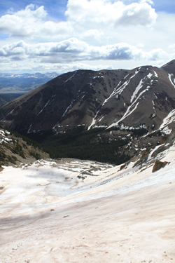 but for a bridge. The good news was that the logs were in place but the lower of the two most substantial logs was just a few inches above the water. but for a bridge. The good news was that the logs were in place but the lower of the two most substantial logs was just a few inches above the water.
I went first and did a slow and steady traverse as a fall into the water was not an option. I am not talking about a non option because of one would get wet but more of a non option from my kayaking days. This was class 5+ creeking for sure where missing a roll was not an option simply because even having to roll was not a possibility. We both knew this was a short but very serious crossing with little room for error. We both took our time and were soon hoofing our way once again along the road.
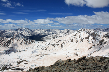
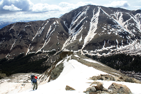
 I suspected that the upper valley held a full load of rotten spring snow but I did not plan to find out if this was the case as I had a different route in mind. On both of my prior walks up the valley, I noted that there appeared to be a route up the east slopes of French Mountain that, given some Spring snow, looked both shorter and much more direct than the guidebook route. My plan was to take this route . . . up a slope to a surmised upper basin and then pick a reasonable snow line to the summit ridge. We went about 3/4 mile above the second stream crossing and at the first real opening in the woods, looked at the eastern slopes I planned to ascend to the summit. The only problem was that creek that flowed down the center of the valley. This particular spot however was pretty flat and had a beaver pond in the center that the stream seemed to split and pass around on both sides. I did not figure for a dry crossing but figured the beavers had left enough dam and debris to give me some chance to easily get across a tributary or two. I suspected that the upper valley held a full load of rotten spring snow but I did not plan to find out if this was the case as I had a different route in mind. On both of my prior walks up the valley, I noted that there appeared to be a route up the east slopes of French Mountain that, given some Spring snow, looked both shorter and much more direct than the guidebook route. My plan was to take this route . . . up a slope to a surmised upper basin and then pick a reasonable snow line to the summit ridge. We went about 3/4 mile above the second stream crossing and at the first real opening in the woods, looked at the eastern slopes I planned to ascend to the summit. The only problem was that creek that flowed down the center of the valley. This particular spot however was pretty flat and had a beaver pond in the center that the stream seemed to split and pass around on both sides. I did not figure for a dry crossing but figured the beavers had left enough dam and debris to give me some chance to easily get across a tributary or two.
 We hiked down to the stream edge and after looking around a bit, Bob took a running jump and made it across. I thought about a similar jump but just couldn't put it together so I dragged a log down to the creek. My placement was poor and the log was pulled parallel to flow, hence not much help. I quit that farce and used the Tevas to cross with only the hassle of wet feet needing some moments to dry on the other side. From there we cut through the willow infested bog, crossing braided channels of the creek here and there and finally doing as I hoped, crossing the last branch on the remains of a beaver dam. We hiked down to the stream edge and after looking around a bit, Bob took a running jump and made it across. I thought about a similar jump but just couldn't put it together so I dragged a log down to the creek. My placement was poor and the log was pulled parallel to flow, hence not much help. I quit that farce and used the Tevas to cross with only the hassle of wet feet needing some moments to dry on the other side. From there we cut through the willow infested bog, crossing braided channels of the creek here and there and finally doing as I hoped, crossing the last branch on the remains of a beaver dam.
Once across, we took to the slope leading to the suspected upper basin, a mix of mostly talus and scree that had clearly seen some traffic but it was unclear if the prior users were of the two or four legged variety . . . I suspect both. The slope was a slog at times but without to much problem yielded entrance to a more gently sloped upper basin chocked full of large talus and boulders. I love this type of boulder hopping/climbing though Bob is a much lesser fan of the terrain. I think it 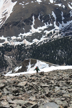 likely comes from my caving days and crossing through rooms laden with large and unsteady chunks of breakdown from the cave roof above. Regardless, we both hopped steadily upward until we reached the flat below multiple snow slopes leading to what we hoped was the summit ridge. likely comes from my caving days and crossing through rooms laden with large and unsteady chunks of breakdown from the cave roof above. Regardless, we both hopped steadily upward until we reached the flat below multiple snow slopes leading to what we hoped was the summit ridge.
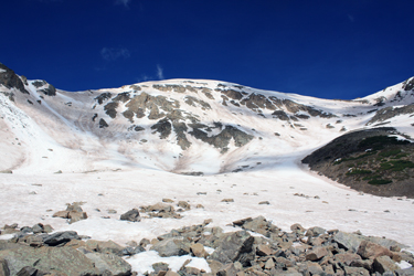
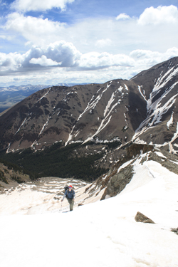
We found were lots of snow slopes, but most were guarded by cornices that were being steadily warmed by the sun and clearly a hazard. Given that the temperature in Leadville when we passed through the night before was still in the 50's, we did not expect a serious freeze up high but still hoped for enough to accomplish the climb. The route selection came down to a gentle route to the right or a bit of a thread the needle route up steeper ground to the left. The left route had seen a few recent cornice falls that had brought a fair amount of snow most of the way to the basin flats, likely a day or two before. Looking at the remaining, rocks that could promote a point release and the surprisingly hard snow under foot, we figured we had a short window to climb so long as we avoided going under any cornices, chose to stay away from point release zones and stuck with a good gravity line below the non corniced section of the ridge. We were off to the left route.
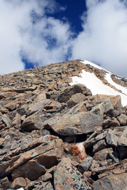
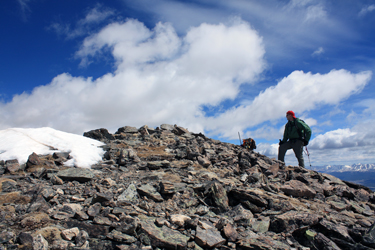
 Bob and I made steady time as I led and kicked a set of steps using my usual duck footed technique. We topped out the snow climb on what I hoped was the summit ridge though I will admit to doubts seeing how far away Casco was. We could see high ground above us and I figured we were summit bound but that we likely had a false summit in our future. The ridge gave us a snow free route upward and we both climbed steadily up the class 2 terrain to what we soon realized was the summit proper. With every ten yards or so, the connecting ridge, including Frasco Benchmark, would reveal more of its length, indicating that were Bob and I made steady time as I led and kicked a set of steps using my usual duck footed technique. We topped out the snow climb on what I hoped was the summit ridge though I will admit to doubts seeing how far away Casco was. We could see high ground above us and I figured we were summit bound but that we likely had a false summit in our future. The ridge gave us a snow free route upward and we both climbed steadily up the class 2 terrain to what we soon realized was the summit proper. With every ten yards or so, the connecting ridge, including Frasco Benchmark, would reveal more of its length, indicating that were 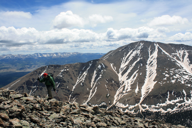 were indeed summit bound. I arrived on top and noted that we had chosen the right and perhaps only route out of the eastern upper basin. For all of the ease offered by the more gentle slope to the right, the ridge leading from the terminus of the other climb was a fully corniced ridge line and no place to be on this warm of a day. We took a short break on the top, drank and ate, and then hefted the packs for the trip back down. I knew the sun was working its evil on the ascent slope but I felt that we'd be fine on the descent so long as we stuck to our centerline route. were indeed summit bound. I arrived on top and noted that we had chosen the right and perhaps only route out of the eastern upper basin. For all of the ease offered by the more gentle slope to the right, the ridge leading from the terminus of the other climb was a fully corniced ridge line and no place to be on this warm of a day. We took a short break on the top, drank and ate, and then hefted the packs for the trip back down. I knew the sun was working its evil on the ascent slope but I felt that we'd be fine on the descent so long as we stuck to our centerline route.
 We arrived at the top of the slope and found the snow in good enough shape to avoid the need to drop off the other flank of the peak. The snow took heel plants well and we were on the bottom and across the flats in less than ten minutes, spending no more time than necessary on the admittedly warming slopes. We took a short breather at the edge of the talus before starting our rock hop to back to the edge of the basin from which we would drop into the stream valley proper. About half way down, Bob took a tumble onto his rear end, issued an expletive or two, and then we were on our way again. We dropped down the mixed talus scree slope to the edge of the stream and hopped across the various small channels until we arrived back at We arrived at the top of the slope and found the snow in good enough shape to avoid the need to drop off the other flank of the peak. The snow took heel plants well and we were on the bottom and across the flats in less than ten minutes, spending no more time than necessary on the admittedly warming slopes. We took a short breather at the edge of the talus before starting our rock hop to back to the edge of the basin from which we would drop into the stream valley proper. About half way down, Bob took a tumble onto his rear end, issued an expletive or two, and then we were on our way again. We dropped down the mixed talus scree slope to the edge of the stream and hopped across the various small channels until we arrived back at 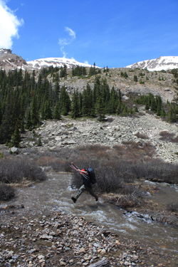 our morning crossing point. Bob was going to jump again and this time I too was up for the leap. No doubt a jump is easier at the end of the day, summit in hand, than it is at the start of the day when the allure of wet boots is much less attractive. our morning crossing point. Bob was going to jump again and this time I too was up for the leap. No doubt a jump is easier at the end of the day, summit in hand, than it is at the start of the day when the allure of wet boots is much less attractive.
I made my crossing with but a half wet foot and Bob followed. He truly showed his athletic style, crossing the creek in two leaps of grace. Soon enough we were back on the trail and on our way down to the upper stream crossing. The water was up and a few feet of the lower log were now under water but we still made the crossing without incident. We hiked on down the road to the crossing of Halfmoon Creek and steeled ourselves for a seriously cold crossing. I went first, retracing my course across the creek diagonally through the vehicle ford. The water was higher and more forceful but the crossing was soon over with. I did however signal to Bob, after trying not to wing him with the Tevas, that it would be better to cross about 50 to 100 feet lower downstream where the stream split into two channels. While both channels would make for challenging crossings, the opportunity to split 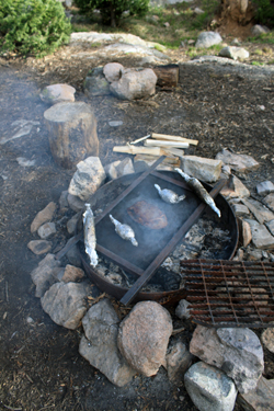 the traverse into two halves was no doubt a good idea. Certainly an idea I should have taken advantage of. Bob made a successful crossing. the traverse into two halves was no doubt a good idea. Certainly an idea I should have taken advantage of. Bob made a successful crossing.
We both walked to the truck, bare below the waist but for my u/w and hiking boots and he the same but for Tevas, quite a sight for anyone who might come to the trail head but we are talking June so the parking area was predictably without witnesses. The climb took about 7 1/2 hours and gave us a route outside of the guidebook norm, another Centennial summit, and a snow climb, albeit on snow that urged much caution with regard to route selection.
Our next stop was the Safeway in Leadville, for the makings of dinner, and then we were off to hopefully score a campsite on the approach road leading to the trail head for our next day's attempt of the Grizzly Couloir on Grizzly Peak. We noted that the campgrounds on the eastern side of Independence Pass were about empty and thought that we might really score a site in Lincoln Gulch an sure enough an hour alter we had a great spot, the tent was up, the fire was going and smell of London broil filled the air. Camping at its best!
|
