Cottonwood Peak
February 3, 2013 - Hot Springs Canyon Trail - a winter attempt
I've looked at the northern Sangre de Christo Range for years but never climbed any of the Bicentennial 13'ers that populate that portion of the range. The weather report called for a bluebird day, it was February, and Bob was willing to go on one of my usual "oh it's not that far and there isn't that much snow" falsehood based misery trips. I don't fib on purpose but my thoughts are always based upon the subjective analysis of how bad can a day in the mountains be compared to waking up to live that same day in Baltimore, MD.
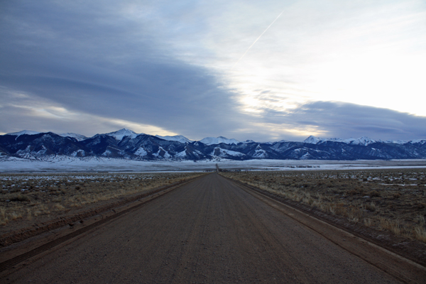
 We drove to Salida, motelled it on Saturday night and were at the Hot Springs Canyon Trailhead the next morning by 7:30. The temperature in Salida as nearly 30 degrees but the temp on Saguache County Road GG was 6 degrees. I had my gear ready to go but I wanted the big hand on the clock to hit an even number before I got out of the truck . . . that even number was 12, as in 8:00 a.m. I was hoping for an inversion with warm air up high and would you believe that the warm air dropped onto the truck at about 7:55 and to my amazement . . . the outside temp rose about 22 degrees in 2 minutes! I did not believe it . . . until I got out to see for my self and it was for real. We drove to Salida, motelled it on Saturday night and were at the Hot Springs Canyon Trailhead the next morning by 7:30. The temperature in Salida as nearly 30 degrees but the temp on Saguache County Road GG was 6 degrees. I had my gear ready to go but I wanted the big hand on the clock to hit an even number before I got out of the truck . . . that even number was 12, as in 8:00 a.m. I was hoping for an inversion with warm air up high and would you believe that the warm air dropped onto the truck at about 7:55 and to my amazement . . . the outside temp rose about 22 degrees in 2 minutes! I did not believe it . . . until I got out to see for my self and it was for real.
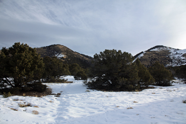
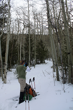 We hefted the packs and set off up the trail. I knew from others' reports that the trail would be deceptively tame as to the vertical gain, as in a secretive dump 4000 feet of gain on you over the course of about 5 miles. We set off along the route to the canyon mouth, following a snow covered trail that was easily perceived by the swale in the shallow 4 to 8 inches of snow that covered the last of the desert slopes. The trail cut into the canyon proper and rose first through a band of gambel oak and the into the aspen as the side slopes slowly climbed but never really took to pinching, at least not yet. We covered another mile before stopping to put on the snowshoes, which are a bit of a hassle but at that hour of the morning, I will do just about anything to get over the mind bending effort required to boot hike through deepening snow. We added shoes and after another half hour or so came to a wide clearing and spotted the trail cutting off to the right, taking the right branch where the drainage split. We hefted the packs and set off up the trail. I knew from others' reports that the trail would be deceptively tame as to the vertical gain, as in a secretive dump 4000 feet of gain on you over the course of about 5 miles. We set off along the route to the canyon mouth, following a snow covered trail that was easily perceived by the swale in the shallow 4 to 8 inches of snow that covered the last of the desert slopes. The trail cut into the canyon proper and rose first through a band of gambel oak and the into the aspen as the side slopes slowly climbed but never really took to pinching, at least not yet. We covered another mile before stopping to put on the snowshoes, which are a bit of a hassle but at that hour of the morning, I will do just about anything to get over the mind bending effort required to boot hike through deepening snow. We added shoes and after another half hour or so came to a wide clearing and spotted the trail cutting off to the right, taking the right branch where the drainage split.
 We'd been going up through a minimally tree shaded and relatively wide canyon but now the game changed. The canyon walls closed and the aspen gave way to taller pines, all making for a perfect place for the snow to accumulate. The route now cut left and right as it traversed a more serpentine course. We were not just shoeing along anymore, we were taking turns stomping a snow shoe trench through powder that was now running 18 to 24 inches deep and not giving much in the way of support. We tried to keep a steady pace and swapped out the lead about every 20 or 30 minutes as the lead person tired. We knew we would eventually come to the head of this valley and we eventually did, but not before really getting worked by the effort. My quads were screaming but we did eventually get to a point where we could see the small knob shown on the topo map which indicted the official end of the canyon. At this point we are tired and swapping lead every 10 minutes just to get to the slope we can see ahead and which we believe, will have thinner snow cover. We'd been going up through a minimally tree shaded and relatively wide canyon but now the game changed. The canyon walls closed and the aspen gave way to taller pines, all making for a perfect place for the snow to accumulate. The route now cut left and right as it traversed a more serpentine course. We were not just shoeing along anymore, we were taking turns stomping a snow shoe trench through powder that was now running 18 to 24 inches deep and not giving much in the way of support. We tried to keep a steady pace and swapped out the lead about every 20 or 30 minutes as the lead person tired. We knew we would eventually come to the head of this valley and we eventually did, but not before really getting worked by the effort. My quads were screaming but we did eventually get to a point where we could see the small knob shown on the topo map which indicted the official end of the canyon. At this point we are tired and swapping lead every 10 minutes just to get to the slope we can see ahead and which we believe, will have thinner snow cover.
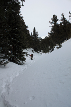
 We get to the base of the nipple and turn right to ascend a gully to the saddle that marks the start of the climb up the ridge to the summit. Half way up to the saddle Bob calls lunch, it was every bit of 1 p.m. and we both needed to eat something. We found a fallen tree to sit on, ate a decent lunch, and then elected to drop the shoes to boot our way through the last snow to more bare upper slopes. We headed upward and after crossing one knee deep snow section, were on the icy rock and thinly covered tundra leading up the ridge. We get to the base of the nipple and turn right to ascend a gully to the saddle that marks the start of the climb up the ridge to the summit. Half way up to the saddle Bob calls lunch, it was every bit of 1 p.m. and we both needed to eat something. We found a fallen tree to sit on, ate a decent lunch, and then elected to drop the shoes to boot our way through the last snow to more bare upper slopes. We headed upward and after crossing one knee deep snow section, were on the icy rock and thinly covered tundra leading up the ridge.
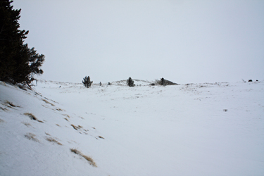
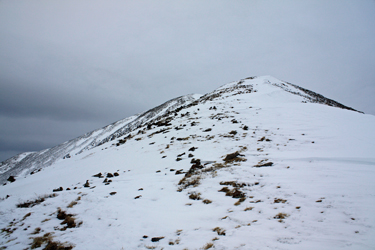 I was slow, too slow and hurting, as the deeper snow over the first four plus miles had drained me to the core. But the air was still, we were warm and one foot was still going in front of the other. We climbed to the first highpoint, which we knew to be a false summit and the looked on to the next high point . . . the summit. It was now strictly a "mind over matter" climb but the summit was in sight and we needed only a few hundred feet of vertical to score what we had invested over 6 hours in trying to attain. The terrain was not bad, no boulder hopping through talus, just a long slog up the snow covered slope. We traversed a broad cornice without risk and then a final 100 yards to the highest point. I was slow, too slow and hurting, as the deeper snow over the first four plus miles had drained me to the core. But the air was still, we were warm and one foot was still going in front of the other. We climbed to the first highpoint, which we knew to be a false summit and the looked on to the next high point . . . the summit. It was now strictly a "mind over matter" climb but the summit was in sight and we needed only a few hundred feet of vertical to score what we had invested over 6 hours in trying to attain. The terrain was not bad, no boulder hopping through talus, just a long slog up the snow covered slope. We traversed a broad cornice without risk and then a final 100 yards to the highest point.
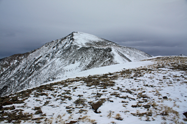 The only problem was this was not the summit . . . no the summit was another mile beyond where we were and reaching it would require us to lose a couple hundred feet to move upward again on the final slopes. It was 3 p.m., the wind had just started, the sun would be down by 6 p.m. . . . making the crossing to the true summit and back would take no less than two hours. It was obvious, we were not going to score Cottonwood Peak on this outing. The was no debate, no waffling, no whining, we just looked back toward the valley behind us and started down. The only problem was this was not the summit . . . no the summit was another mile beyond where we were and reaching it would require us to lose a couple hundred feet to move upward again on the final slopes. It was 3 p.m., the wind had just started, the sun would be down by 6 p.m. . . . making the crossing to the true summit and back would take no less than two hours. It was obvious, we were not going to score Cottonwood Peak on this outing. The was no debate, no waffling, no whining, we just looked back toward the valley behind us and started down.
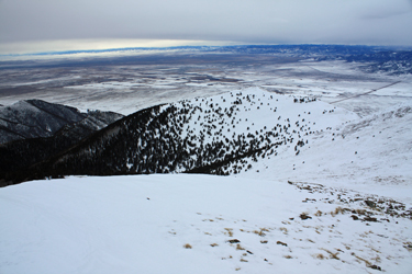 We were tired, the slope that was a slow slog up was now a steep downslope and that would be the story from the turn around point to the truck. We made our way back down the bare upper slopes and dropped into the swale that would lead first to our snow shoe stash and then to our trench leading on back town the valley, now oh so far away. The snow shoes were recovered, Gu's shot, and more Gatorade put down in anticipation of the hike out. The hike out was a smooth 3 hour jaunt but it left no doubt as to the constant climb involved in this route. The descent alternated between downward steps and downward slides for the first two miles before the grade did lessen enough that dropping onto the behind was not a risk taken with every other step. We arrived back at the truck, at 6 p.m. almost on the dot, and the arrival of night as the last bit of daylight faded behind the San Juans to the west. We were tired, the slope that was a slow slog up was now a steep downslope and that would be the story from the turn around point to the truck. We made our way back down the bare upper slopes and dropped into the swale that would lead first to our snow shoe stash and then to our trench leading on back town the valley, now oh so far away. The snow shoes were recovered, Gu's shot, and more Gatorade put down in anticipation of the hike out. The hike out was a smooth 3 hour jaunt but it left no doubt as to the constant climb involved in this route. The descent alternated between downward steps and downward slides for the first two miles before the grade did lessen enough that dropping onto the behind was not a risk taken with every other step. We arrived back at the truck, at 6 p.m. almost on the dot, and the arrival of night as the last bit of daylight faded behind the San Juans to the west.
|
