Ben Lomond
Ben Lomond Track, Queenstown, New Zealand - March 10, 2011
A trip to New Zealand would not be complete without at least attempting a climb of something to get a bit of elevation and a view of some snow capped peaks. My wife and I were on the south island for two weeks of wandering about in a rented RV and of course a stop in the adrenaline capital of the world, Queenstown, is just about impossible to avoid. However when asked if I'd spent lots of money there doing the bungy jump and similar pursuits, I had to admit that I took an alternate track, the Ben Lomond Track . . .
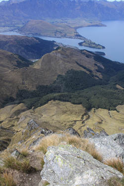
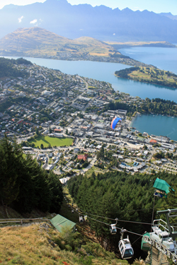 Ben Lomond forms the backdrop to Queenstown on one side, perhaps acting to balance the majesty of the Remarkables, a rugged series of peaks and ridges that rise above town on the opposite side of Lake Wakatipu. The climb offers between three and four thousand feet of vertical, depending upon your approach. There is the classic approach from the base or the less classic ride up the first part of the climb aboard the gondola that serves a lofty visitor center and base for parasailing rides, a bungy jump platform and four wheel cart luge track. My wife and opted to start from the tourist perspective and took the gondola up, cutting about 800 feet off the ascent. Ben Lomond forms the backdrop to Queenstown on one side, perhaps acting to balance the majesty of the Remarkables, a rugged series of peaks and ridges that rise above town on the opposite side of Lake Wakatipu. The climb offers between three and four thousand feet of vertical, depending upon your approach. There is the classic approach from the base or the less classic ride up the first part of the climb aboard the gondola that serves a lofty visitor center and base for parasailing rides, a bungy jump platform and four wheel cart luge track. My wife and opted to start from the tourist perspective and took the gondola up, cutting about 800 feet off the ascent.
 Unlike the climbs of Colorado, there seemed to be no issue of an off the summit before the arrival of requisite noon thunderstorms . . . the gondola does not even start running until 9 a.m. After a dozen years of alpine starts and 10 a.m. summits, the thought of a 9 a.m. start was offensive to every climbing instinct I have developed over the years. Well, we did just that, leaving the camp ground at 8:30, parking the RV in town and catching a quick meat pie breakfast along the way. At about 9:10 we boarded the gondola and within a few minutes were whisked up the first part of the climb without even drawing a deep breath. The view of the lake, town and expanse of countryside is impressive and we took time to walk about the visitor center to watch the parasail riders drifting off the side of the heights and sailing down to a field in the town far below. Unlike the climbs of Colorado, there seemed to be no issue of an off the summit before the arrival of requisite noon thunderstorms . . . the gondola does not even start running until 9 a.m. After a dozen years of alpine starts and 10 a.m. summits, the thought of a 9 a.m. start was offensive to every climbing instinct I have developed over the years. Well, we did just that, leaving the camp ground at 8:30, parking the RV in town and catching a quick meat pie breakfast along the way. At about 9:10 we boarded the gondola and within a few minutes were whisked up the first part of the climb without even drawing a deep breath. The view of the lake, town and expanse of countryside is impressive and we took time to walk about the visitor center to watch the parasail riders drifting off the side of the heights and sailing down to a field in the town far below.
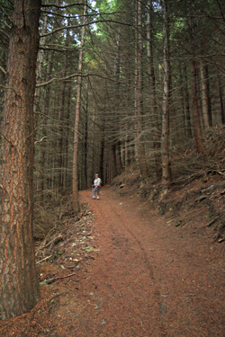
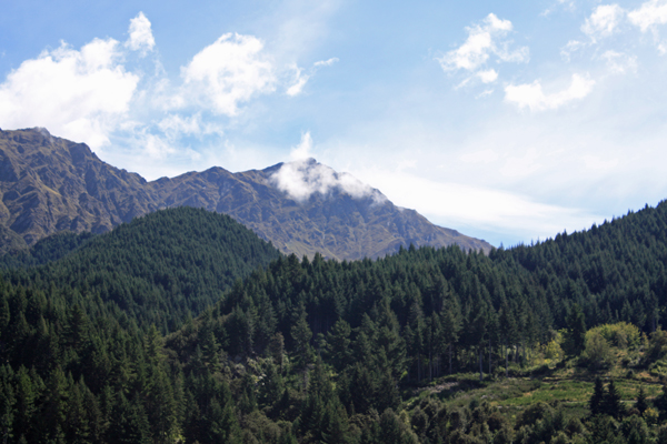
 Then we were off to the start of the Ben Lomond Track, which promised about a three mile one way hike to the summit of Ben Lomond, elevation 1748 meters or 5680 feet. I think that "track" is a good description of the course, but one could also use the word "trench" at many points along the way. The start of trail is well signed and traverses steeply up through a grove of pine woods, a dark path through substantial trees, decorated along the way with lots of mushrooms. After not too long the trees thin as you reach a tree line of sorts and Ben Lomand comes into view in the distance. Then we were off to the start of the Ben Lomond Track, which promised about a three mile one way hike to the summit of Ben Lomond, elevation 1748 meters or 5680 feet. I think that "track" is a good description of the course, but one could also use the word "trench" at many points along the way. The start of trail is well signed and traverses steeply up through a grove of pine woods, a dark path through substantial trees, decorated along the way with lots of mushrooms. After not too long the trees thin as you reach a tree line of sorts and Ben Lomand comes into view in the distance.
 The trail takes a dip to drop through a section of open ground where forestry folks were dropping lots of small pines, reason unknown but most likely tied to the fact that the pines did not appear to be the native flora for the hillside. The trail from the town below now joins the trail from the gondola terminus and the hike starts in earnest. My wife turned back at this point as her plan was for a day of urban hiking while I took the trip to the summit. The climb from this point is a climbing traverse that eventually joins the ridge line proper and leads to the saddle between Ben Lomond and Bob's Peak. The trail is braided here and there, actually, more likely braided than not, due to wet conditions and the efforts of hikers to avoid the trench aspect of the route. A bit of ugh factor. The trail takes a dip to drop through a section of open ground where forestry folks were dropping lots of small pines, reason unknown but most likely tied to the fact that the pines did not appear to be the native flora for the hillside. The trail from the town below now joins the trail from the gondola terminus and the hike starts in earnest. My wife turned back at this point as her plan was for a day of urban hiking while I took the trip to the summit. The climb from this point is a climbing traverse that eventually joins the ridge line proper and leads to the saddle between Ben Lomond and Bob's Peak. The trail is braided here and there, actually, more likely braided than not, due to wet conditions and the efforts of hikers to avoid the trench aspect of the route. A bit of ugh factor.
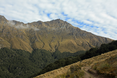
 The grade is steadily steep but ideal for a forceful hike if one is inclined toward speed. After about one and one half hours the saddle is reached, having left the trees well behind for the brown alpine tussock that covers the flanks of the mountain. Here and there one will see a sheep or two grazing but other than those few four leggeds, the most common wildlife seems to be the giant dragon flies that carry four or more passengers across the hilltops en route to the various sights around Queensland. I saw no less than a eight helo flights pass over the saddle during the course of my ascent. The grade is steadily steep but ideal for a forceful hike if one is inclined toward speed. After about one and one half hours the saddle is reached, having left the trees well behind for the brown alpine tussock that covers the flanks of the mountain. Here and there one will see a sheep or two grazing but other than those few four leggeds, the most common wildlife seems to be the giant dragon flies that carry four or more passengers across the hilltops en route to the various sights around Queensland. I saw no less than a eight helo flights pass over the saddle during the course of my ascent.
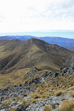
The climb to the summit morphs after the saddle and is very much like a southern version of the hike up Guadalupe Peak or other Chihuahuan desert track, drier vegetation, more rock and a low end class two scramble here and there. The trail climbs another thousand feet to the summit, sticking first to the ridge connecting to the saddle and then switching the the "backside" of the peak and taking on a much more sedate class one course to the summit proper. The summit is marked 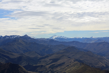 by a concreted summit monument with a pivoting brass dial atop the solidified cairn. The dial can be turned through a full circle and is marked with the names of the various peaks, near and far. One could not see Mt. Cook on the day of my climb but Mt. Aspiring was clear to see as were a number of other snow clad peaks that a Kiwi climber likely can rattle off as I would the 14'ers from atop a Colorado summit. by a concreted summit monument with a pivoting brass dial atop the solidified cairn. The dial can be turned through a full circle and is marked with the names of the various peaks, near and far. One could not see Mt. Cook on the day of my climb but Mt. Aspiring was clear to see as were a number of other snow clad peaks that a Kiwi climber likely can rattle off as I would the 14'ers from atop a Colorado summit.
I chatted on the Summit with a fellow from California, we took the requisite summit shots and got a bit to eat before starting down on the three mile hike to the gondola terminus. There was a touch of wind but given that most of my climbing is not during the summer, I found the mild breeze and 40 degree temperature to be 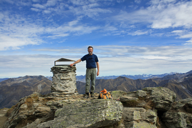 to my liking. After about a half hour on the summit we started down and made good time to the saddle and then down along the ridge traverse to the trial junction and then back up about one half mile of incline to the gondola terminus. I started the climb at about 9:30 and finished at 2:30, pretty much taking the signposted time for hike. to my liking. After about a half hour on the summit we started down and made good time to the saddle and then down along the ridge traverse to the trial junction and then back up about one half mile of incline to the gondola terminus. I started the climb at about 9:30 and finished at 2:30, pretty much taking the signposted time for hike.
Ben Lomond offered a view of the southern Alps, a wonderful day out and the opportunity to make a climb in a land where I'd not had the opportunity to break tree line before. A worthwhile half day for anyone in Queenstown and a viable alternative the adrenaline laced fare consumed by so many.
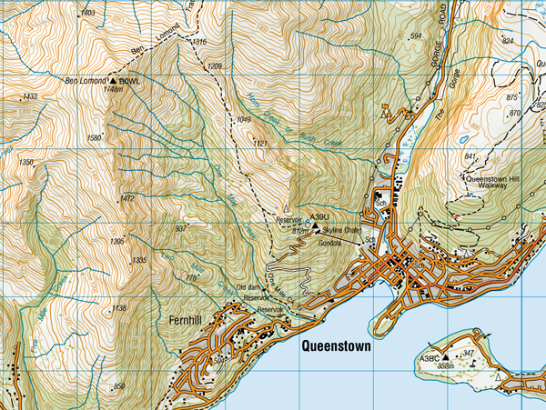
Finally, some topo for those so inclined . . .
|
